- Home
- :
- All Communities
- :
- Products
- :
- ModelBuilder
- :
- ModelBuilder Questions
- :
- How to add the model output to a new mapdocument o...
- Subscribe to RSS Feed
- Mark Topic as New
- Mark Topic as Read
- Float this Topic for Current User
- Bookmark
- Subscribe
- Mute
- Printer Friendly Page
How to add the model output to a new mapdocument or replace the existing table of content?
- Mark as New
- Bookmark
- Subscribe
- Mute
- Subscribe to RSS Feed
- Permalink
- Report Inappropriate Content
Hi,
I am trying to create a tool using model builder in Arcmap 10.4 which will allow the user to draw a polygon interactively and clip all layers within the polygon. The clipped layers will then be saved in an output file geodatabase containing a featuredataset having same name as the original layers. My input layers are from a file geodatabase containing featuredataset. My idea is to add the output to a new map document automatically or replace the existing TOC. I am attaching my tool, input and output file geodatabase. I will appreciate any kind of help regarding the Problem.
Regards,
Rimon
- Mark as New
- Bookmark
- Subscribe
- Mute
- Subscribe to RSS Feed
- Permalink
- Report Inappropriate Content
This requires a little Python scripting using the Calculate Value tool. You need to write a function (placed in the Calculate Value code block) that opens a template MXD and sets all the new paths using the arcpy.mapping module. The inputs to the function would be the template MXD (this could be a model element) and the path to your output gdb. The calculate value expression would be something like:
save_mxd(r"%mxd_template%", r"%output_mxd_folder%", r"%output_gdb%")- Mark as New
- Bookmark
- Subscribe
- Mute
- Subscribe to RSS Feed
- Permalink
- Report Inappropriate Content
Hi,
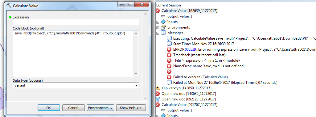
Thanks for your reply. I am new to python. I tried to evaluate the expression above as you stated within the calculate value. But it takes save_mxd as a variable I think and It gives error result. Can you look at it and see what is the problem? Thanks in advance.
- Mark as New
- Bookmark
- Subscribe
- Mute
- Subscribe to RSS Feed
- Permalink
- Report Inappropriate Content
you have nothing in the expression box you need to make it a function and usewhat Curtis supplied should go in the code box. your line should go in the expression box to call the function which is names save_mxd
Calculate Value—Tools | ArcGIS Desktop look at the provided image from the help

- Mark as New
- Bookmark
- Subscribe
- Mute
- Subscribe to RSS Feed
- Permalink
- Report Inappropriate Content
Hi Dan!
Thanks a lot for your reply. I tried to make a function in calculate value tool but did not succeed. Instead if I try to elaborate and create a script in python that will take a geodatabase/featuredataset as input and place the featuredataset in TOC of a new mapdocument. My intension is to use the same dataframe from the current map document. My Idea is like this,
# Import module
import os
import arcpy
from arcpy import env
# Set input parameter (I want to connect this script to the model output which is a geodatabase and param0 will take the .gdb as input)
def getParameterInfo(self):
param0 = arcpy.Parameter(
displayName="Input Geodata",
name="in_workspace",
datatype="DEGeodatasetType",
parameterType="Required",
direction="Input")
return param0
# Set environment
arcpy.env.workspace = ("param0")
mxd = arcpy.mapping.MapDocument("CURRENT")
# Copy the dataframe from current mxd to a new mxd and add the inputted gdb to map document.
for df in arcpy.mapping.ListDataFrames(mxd):
for ds in arcpy.mapping.ListDataset(feature_type='feature')
for fc in arcpy.mapping.ListFeatureClasses()
mxd.saveACopy(r"C:\Users\attrab01\Downloads\PK\\" + "Project"+ ".mxd")
del mxd1
# Open the new mxd automatic
os.startfile(r"C:\Users\attrab01\Downloads\PK\\" + "Project" + ".mxd")
This is a very basic and logical structure of my desired output. I would really appreciate if you can give me an exaple how to compile the code in python. Thanks in advance.
- Mark as New
- Bookmark
- Subscribe
- Mute
- Subscribe to RSS Feed
- Permalink
- Report Inappropriate Content
To get the code into a readable format first. Your code should be using parameters rather than hard coded, like your references to the folder location. You can make a script tool for use in ArcToolbox possibly, or simply use a python IDE to run the script. I am guessing that you did neither or you would have reported error message or it would have worked