- Home
- :
- All Communities
- :
- Products
- :
- ArcGIS Pro
- :
- ArcGIS Pro Questions
- :
- The digitized feature (on top of an image) is shif...
- Subscribe to RSS Feed
- Mark Topic as New
- Mark Topic as Read
- Float this Topic for Current User
- Bookmark
- Subscribe
- Mute
- Printer Friendly Page
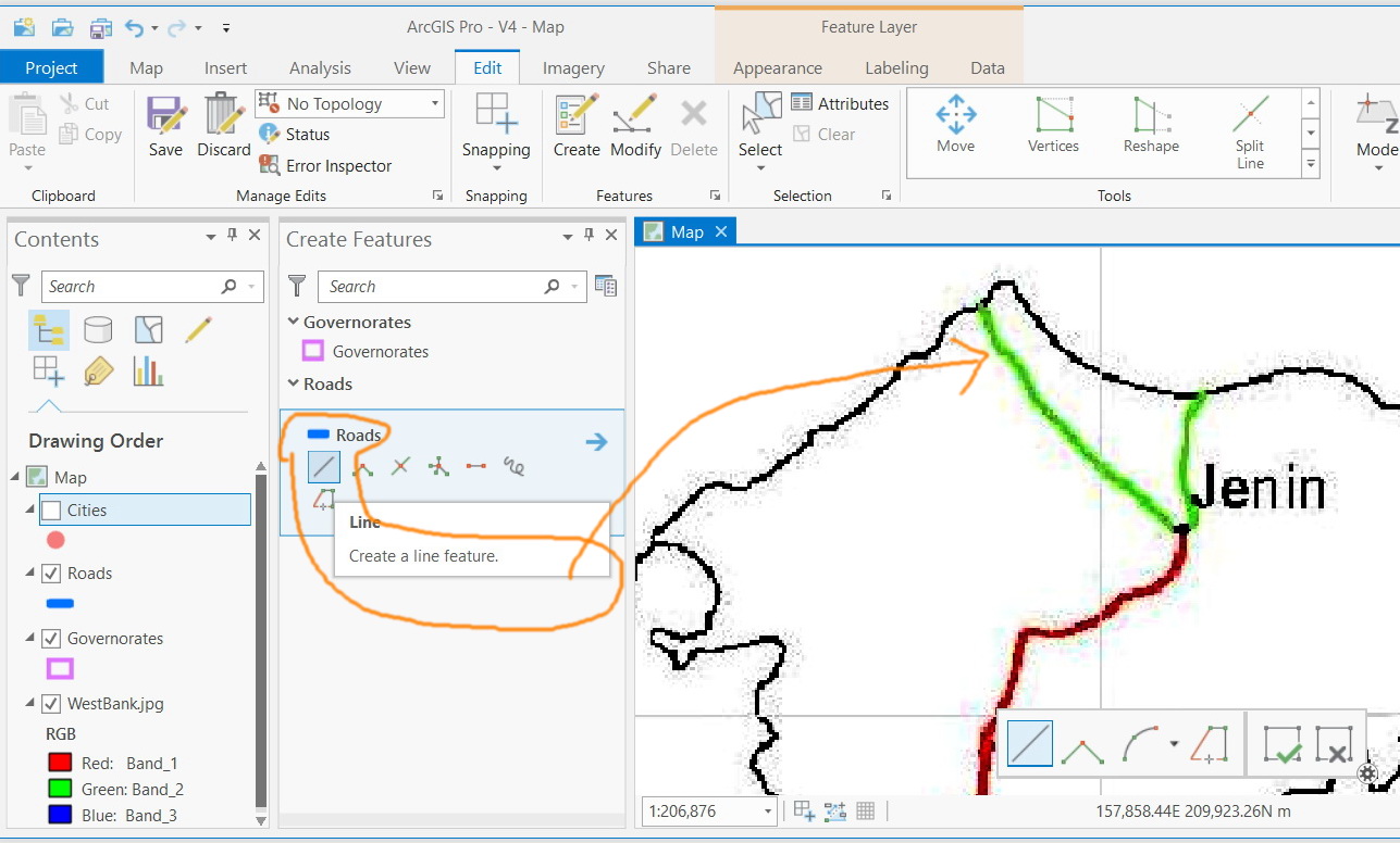
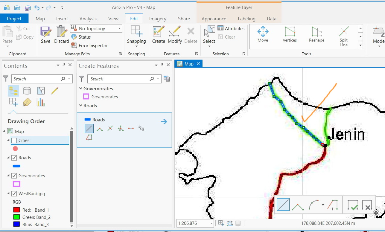
The digitized feature (on top of an image) is shifted as editing is finished,
- Mark as New
- Bookmark
- Subscribe
- Mute
- Subscribe to RSS Feed
- Permalink
- Report Inappropriate Content
The digitized feature (on top of an image) is shifted as editing is finished,
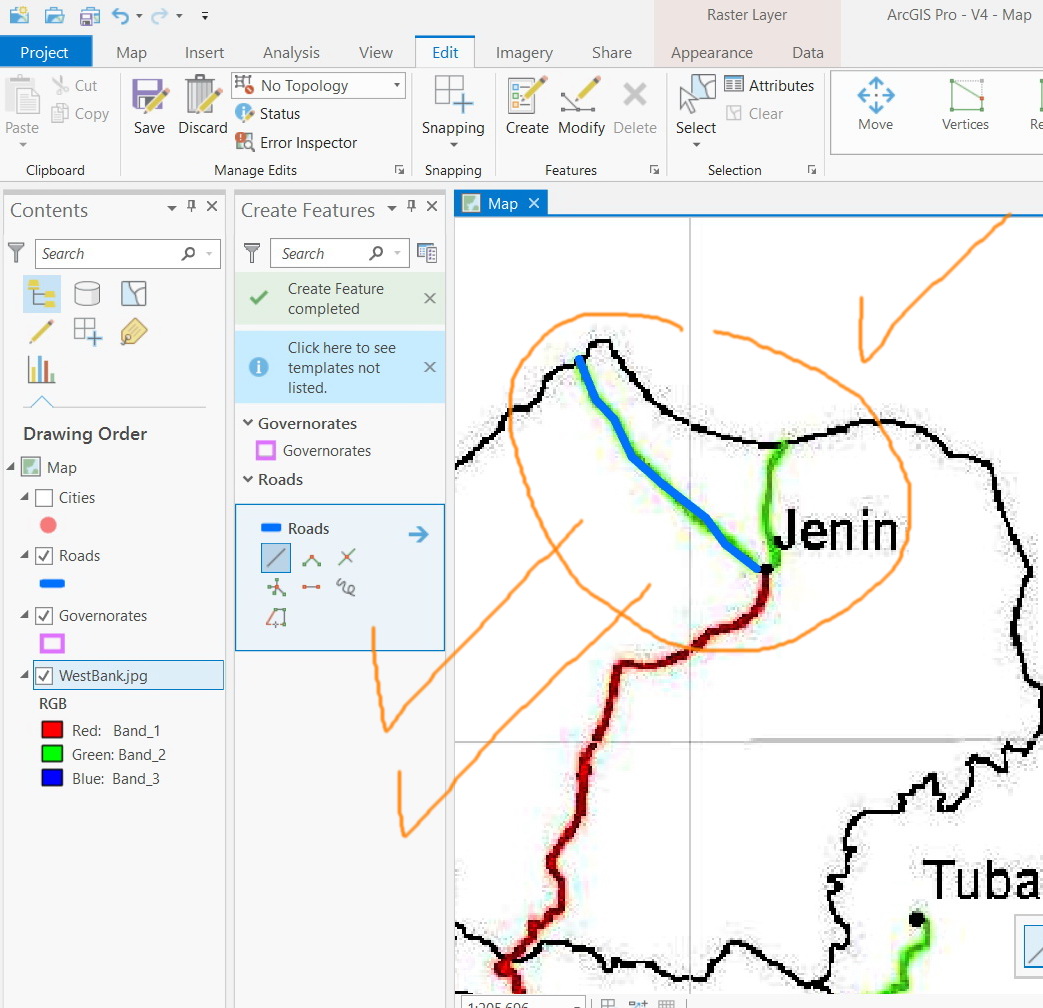
I’m wondering why the digitized feature (on top of an image) is shifted when finish editing as shown in the screenshot below
What might be the issue here?

Jamal Numan
Geomolg Geoportal for Spatial Information
Ramallah, West Bank, Palestine
- Mark as New
- Bookmark
- Subscribe
- Mute
- Subscribe to RSS Feed
- Permalink
- Report Inappropriate Content
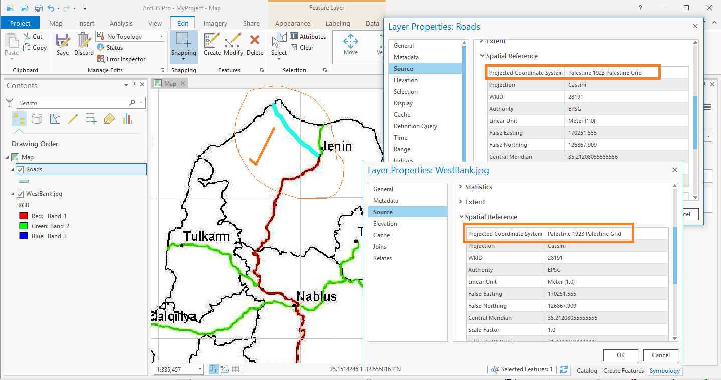
are the coordinate systems of the map, the feature being created and the image the same including their datum
- Mark as New
- Bookmark
- Subscribe
- Mute
- Subscribe to RSS Feed
- Permalink
- Report Inappropriate Content
Thanks Dan.
All what I did is digitizing on top of an image. Why should I have even a coordinate for the feature class or for the image?
However, with same settings, this is, of course, can be done in ArcMap with no issues as shown in the screenshot below. Just in case, the data is attached.

Jamal Numan
Geomolg Geoportal for Spatial Information
Ramallah, West Bank, Palestine
- Mark as New
- Bookmark
- Subscribe
- Mute
- Subscribe to RSS Feed
- Permalink
- Report Inappropriate Content
did you check this in Pro? and the same conditions in map? feature snapping? other things will explain the situation, you just need to rule out the peripheral factors
- Mark as New
- Bookmark
- Subscribe
- Mute
- Subscribe to RSS Feed
- Permalink
- Report Inappropriate Content
I really wasn't expecting this comment from an experienced GIS user:
Why should I have even a coordinate for the feature class or for the image?
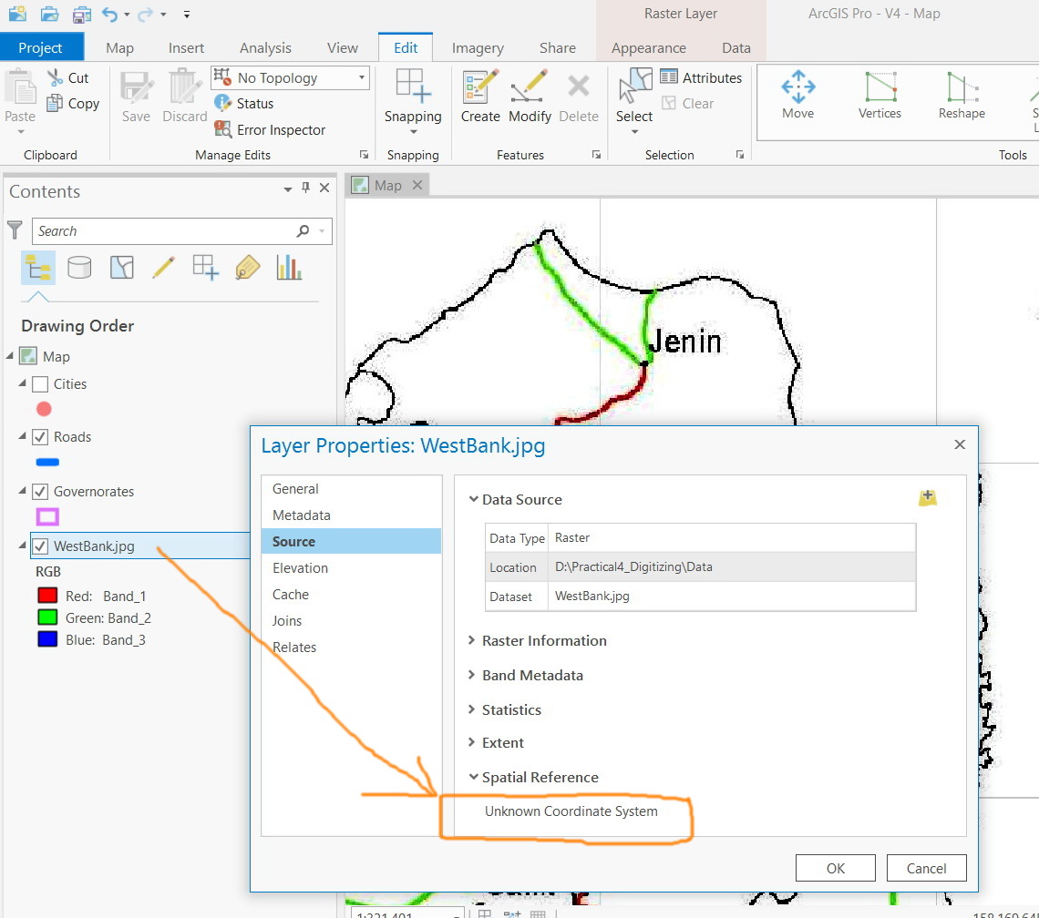
You really should avoid working in a GIS with a Unknown coordinate system. It is not best practices to do so.
Here is a nice webinar on the topic:
A coordinate system is responsible for ensuring your features display in the right location. You will learn practical guidelines for solving challenges as well as techniques to correct problems caused by unknown and missing coordinate system information.
- Mark as New
- Bookmark
- Subscribe
- Mute
- Subscribe to RSS Feed
- Permalink
- Report Inappropriate Content
Correct. I was ignoring the fact that:
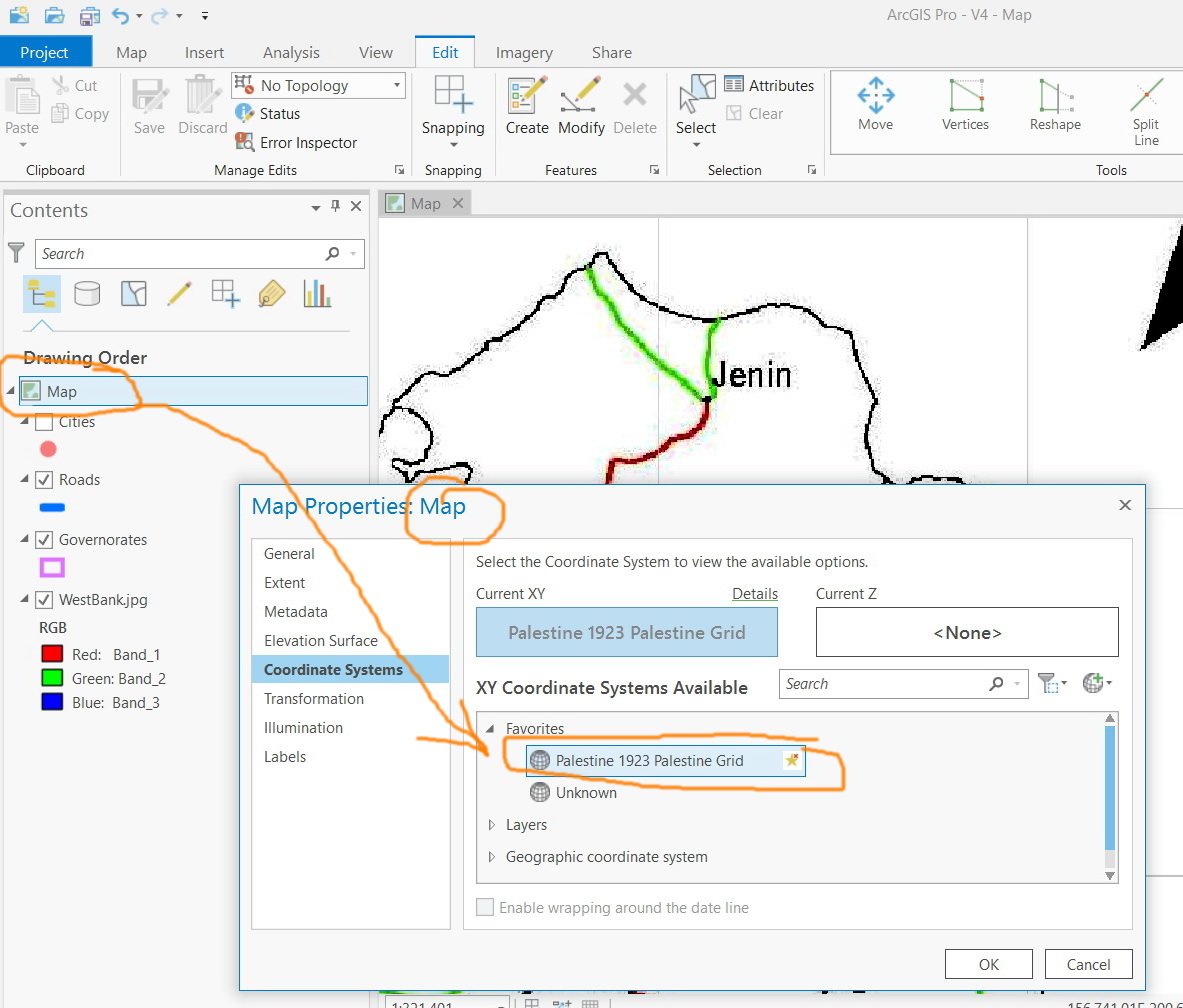
-the default coordinate system of “map” is “WGS 1984 Web Mercator” but not “unknown” as in ArcMap
-adding the first feature class to the “map” will never get it switched to the feature class’ coordinate system as in ArcMap
Assigning the same coordinate system for “map” and “feature class” resolves the issue.
We can’t forget 15 years of working in ArcMap in few days!

Jamal Numan
Geomolg Geoportal for Spatial Information
Ramallah, West Bank, Palestine
- Mark as New
- Bookmark
- Subscribe
- Mute
- Subscribe to RSS Feed
- Permalink
- Report Inappropriate Content
I knew it had to be the coordinates system differences or lack thereof... things just don't 'jump' around.
- Mark as New
- Bookmark
- Subscribe
- Mute
- Subscribe to RSS Feed
- Permalink
- Report Inappropriate Content
I tried this and it worked well when I unified the coordinate systems. 
- Mark as New
- Bookmark
- Subscribe
- Mute
- Subscribe to RSS Feed
- Permalink
- Report Inappropriate Content
I indicated the root of the problem earlier on. The advice is long standing. Never assume anything about the coordinate systems of your data and/or environment.
'Projection on the fly' was introduced many years ago to alleviate the 'my data don't line up' issues because they were physically displaced on the map....
Now that it is here, the questions is 'my data don't line up' because assumptions are made about how the program is to work. Just try using Define Projection tool instead of the Project tool to see what I mean