- Home
- :
- All Communities
- :
- Products
- :
- Geoprocessing
- :
- Geoprocessing Questions
- :
- how can I upload raster and polygons to a gps unit
- Subscribe to RSS Feed
- Mark Topic as New
- Mark Topic as Read
- Float this Topic for Current User
- Bookmark
- Subscribe
- Mute
- Printer Friendly Page
how can I upload raster and polygons to a gps unit
- Mark as New
- Bookmark
- Subscribe
- Mute
- Subscribe to RSS Feed
- Permalink
- Report Inappropriate Content
Hi I need to be able to upload a raster image and a polygon to a garmin unit. Does anyone know what conversion tool, if any, is available in arc gis 10.5 that can do this conversion. Or any other method that I can use to create a file that the garmin will recognize.
Thanks,
Jane
- Mark as New
- Bookmark
- Subscribe
- Mute
- Subscribe to RSS Feed
- Permalink
- Report Inappropriate Content
too many garmin units to comment. and they appear to have limited alternate upload capabilitys according to a Dr Google search (ie .img for images, but not your standard img.
You will have better luck with tracklogs and waypoints, even from google earth etc
- Mark as New
- Bookmark
- Subscribe
- Mute
- Subscribe to RSS Feed
- Permalink
- Report Inappropriate Content
Thanks Dan but what I am looking for is how to upload a map that contains
the ortho image and polygons needed to GPS so they can be used to help with
a survey on the ground.
I found a MapToGarminCustomMap
<https://bitbucket.org/wankoelias/maptogarmincustommap>
tool, downloaded it added it to my tool box but it tells me the tool does
not exist.
Any ideas?
<https://bitbucket.org/wankoelias/maptogarmincustommap>
- Mark as New
- Bookmark
- Subscribe
- Mute
- Subscribe to RSS Feed
- Permalink
- Report Inappropriate Content
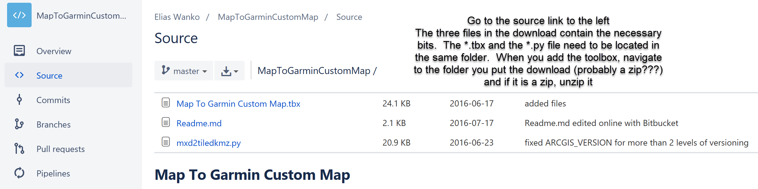
Jane
I didn't download the file, but I went to "Source" link to see what was there.
Here is my visual summary
- Mark as New
- Bookmark
- Subscribe
- Mute
- Subscribe to RSS Feed
- Permalink
- Report Inappropriate Content
Got it to work, thanks for your help Dan
- Mark as New
- Bookmark
- Subscribe
- Mute
- Subscribe to RSS Feed
- Permalink
- Report Inappropriate Content
glad it worked out Jane
- Mark as New
- Bookmark
- Subscribe
- Mute
- Subscribe to RSS Feed
- Permalink
- Report Inappropriate Content
A little over a year ago a client came to me with a similar question to convert some points (about 10.000) into a GPX file. When I asked what the specific purpose was, I started to explain the advantages of using Collector for ArcGIS - Collect & Update Data in the Field | Esri and being able to collect data in a structured way and taking photo's and being able to follow progress of field work by configuring a Esri Software | Operations Dashboard for ArcGIS .
In case your Garmin device has Android OS you probably can install Collector and publish your data in ArcGIS Online: Prepare your data in ArcGIS Desktop—Collector for ArcGIS | ArcGIS
This client is now completing their second validation of all those points in the field and presented at our user conference. You can read more about this here: CCU 2017 - Seguimiento, Monitoreo y Actualización de la compensación forestal de la PTAR Bello - EPM (although it is in Spanish).
So the question is, what do you want to do with your data in the field?