- Home
- :
- All Communities
- :
- Products
- :
- ArcGIS Online
- :
- ArcGIS Online Questions
- :
- Issues creating local copy for editing
- Subscribe to RSS Feed
- Mark Topic as New
- Mark Topic as Read
- Float this Topic for Current User
- Bookmark
- Subscribe
- Mute
- Printer Friendly Page
- Mark as New
- Bookmark
- Subscribe
- Mute
- Subscribe to RSS Feed
- Permalink
- Report Inappropriate Content
Hi
I'm having issues creating a local copy of a feature service for editing (service in ArcGIS Online, using ArcMap 10.3.1 on desktop).
I can add the feature service to my ToC, but when I right-click to create a local copy, I receive the following error message:
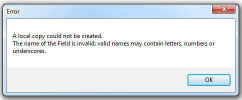
# I've inspected all of the field names of the service in question and all seem to be legitimate (all start with alpha characters, no special characters in strings etc). Field names are:
| objectid |
| globalid |
| GUID_ |
| DEVICE_ID |
| SURVEY_COMMENCED |
| SURVEY_COMPLETED |
| JOB_NAME |
| DATE_INITIATED |
| FACILITATED_BY |
| WORKGROUP |
| Q1_COMPLETED_JSP |
| Q2_CONTROLS_IMPLEMENTED |
| Q3_WORKERS_BRIEFED |
| Q4_BRIEFING_DETAILS |
| Q5_ADDITIONAL_HAZARDS |
| Q6_ADDITIONAL_HAZARDS_NOT_ON_LIST |
| Q7_ADDITIONAL_CONTROL_MEASURES |
| Q8_PART2_SUPERVISOR |
| Q9_PART2_BRIEFING_DATETIME |
| CHECK_JOB_COMPLETED |
| Q10_INCIDENT_NEARMISS |
| Q11_CONTROLS_INEFFECTIVE |
| Q12_CONVERT_SWMS |
| Q13_OTHER_ISSUES |
| Q14_PART3_SUPERVISOR |
| Q15_PART3_REVIEW_DATETIME |
| CreationDate |
| Creator |
| EditDate |
| Editor |
Shape |
# The source of the feature service is Survey 123 (via XForms), which loads the question text as an alias against each field. These questions do contain special characters.
# I am loath to have to recreate my survey with different or shorter questions (as I am trying to replicate an existing business process), but if this is the fix, then so be it.
Has anyone come across this issue with creating local copies for editing? Have you found a fix or workaround?
Thank you in advance!
Solved! Go to Solution.
Accepted Solutions
- Mark as New
- Bookmark
- Subscribe
- Mute
- Subscribe to RSS Feed
- Permalink
- Report Inappropriate Content
Hi Dan
I think I got to the bottom of the issue yesterday (well, more to the point, I changed something and it started working, whether or not that was the cause or not, I don't know).
I think the issue was that the Label field in xforms gets translated to the field aliasname in the feature service. The way I had my form constructed was having the question text in the label field on xforms, which meant very long aliasnames (up to 200 char) and special characters as well.
Once I redesigned my form, and moved the question text into either a note format or into the hint field, I was able to specify much less complex names for the labels.
Once this was complete I was able to create a local copy for editing and then sync changes.
In another thread two other options have been pointed out also:
# Use ArcGIS Pro as it will allow native editing of feature services without the need to go offline
# Use the ::esri::bind options in XForms where you can override field names, aliases, types and lengths.
Thanks again.
- Mark as New
- Bookmark
- Subscribe
- Mute
- Subscribe to RSS Feed
- Permalink
- Report Inappropriate Content
You indicate an 'alias', are these the actual field names? or conversely, what are the aliases?
There are many links with that error.....things like exporting to a shapefile,
- Mark as New
- Bookmark
- Subscribe
- Mute
- Subscribe to RSS Feed
- Permalink
- Report Inappropriate Content
Hi Dan
I think I got to the bottom of the issue yesterday (well, more to the point, I changed something and it started working, whether or not that was the cause or not, I don't know).
I think the issue was that the Label field in xforms gets translated to the field aliasname in the feature service. The way I had my form constructed was having the question text in the label field on xforms, which meant very long aliasnames (up to 200 char) and special characters as well.
Once I redesigned my form, and moved the question text into either a note format or into the hint field, I was able to specify much less complex names for the labels.
Once this was complete I was able to create a local copy for editing and then sync changes.
In another thread two other options have been pointed out also:
# Use ArcGIS Pro as it will allow native editing of feature services without the need to go offline
# Use the ::esri::bind options in XForms where you can override field names, aliases, types and lengths.
Thanks again.
- Mark as New
- Bookmark
- Subscribe
- Mute
- Subscribe to RSS Feed
- Permalink
- Report Inappropriate Content
Glad you figured it out Anthony... field names are a stickler in all esri software
- Mark as New
- Bookmark
- Subscribe
- Mute
- Subscribe to RSS Feed
- Permalink
- Report Inappropriate Content