Turn on suggestions
Auto-suggest helps you quickly narrow down your search results by suggesting possible matches as you type.
Cancel
- Home
- :
- All Communities
- :
- Developers
- :
- JavaScript Maps SDK
- :
- JavaScript Maps SDK Questions
- :
- Measurement Widget: disable tooltips & units
Options
- Subscribe to RSS Feed
- Mark Topic as New
- Mark Topic as Read
- Float this Topic for Current User
- Bookmark
- Subscribe
- Mute
- Printer Friendly Page
08-14-2017
12:02 PM
- Mark as New
- Bookmark
- Subscribe
- Mute
- Subscribe to RSS Feed
- Permalink
- Report Inappropriate Content
Is it possible to disable the icons tooltips in the Measurement Widget sandbox ?

And also disable certain units of measurement that are not necessary for a user?
Thank you,
Andrei
Solved! Go to Solution.
1 Solution
Accepted Solutions
08-14-2017
12:37 PM
- Mark as New
- Bookmark
- Subscribe
- Mute
- Subscribe to RSS Feed
- Permalink
- Report Inappropriate Content
Andrei,
Sure here is a sample for both of those:
<!DOCTYPE html>
<html>
<head>
<meta http-equiv="Content-Type" content="text/html; charset=utf-8">
<meta name="viewport" content="initial-scale=1, maximum-scale=1,user-scalable=no">
<title>Measure Tool</title>
<link rel="stylesheet" href="https://js.arcgis.com/3.21/esri/themes/calcite/dijit/calcite.css">
<link rel="stylesheet" href="https://js.arcgis.com/3.21/esri/themes/calcite/esri/esri.css">
<style>
html,body {
height:100%;
width:100%;
margin:0;
}
body {
background-color:#FFF;
overflow:hidden;
font-family:"Trebuchet MS";
}
#map {
border:solid 2px #808775;
-moz-border-radius:4px;
-webkit-border-radius:4px;
border-radius:4px;
margin:5px;
padding:0px;
}
#titlePane{
width:280px;
}
</style>
<script src="https://js.arcgis.com/3.21/"></script>
<script>
var map;
require([
"dojo/dom",
"esri/Color",
"dojo/keys",
"dojo/parser",
"dojo/query",
"esri/config",
"esri/sniff",
"esri/map",
"esri/SnappingManager",
"esri/dijit/Measurement",
"esri/layers/FeatureLayer",
"esri/renderers/SimpleRenderer",
"esri/tasks/GeometryService",
"esri/symbols/SimpleLineSymbol",
"esri/symbols/SimpleFillSymbol",
"esri/dijit/Scalebar",
"dijit/layout/BorderContainer",
"dijit/layout/ContentPane",
"dijit/TitlePane",
"dijit/form/CheckBox",
"dojo/domReady!"
], function(
dom, Color, keys, parser, query,
esriConfig, has, Map, SnappingManager, Measurement, FeatureLayer, SimpleRenderer, GeometryService, SimpleLineSymbol, SimpleFillSymbol
) {
parser.parse();
//This sample may require a proxy page to handle communications with the ArcGIS Server services. You will need to
//replace the url below with the location of a proxy on your machine. See the 'Using the proxy page' help topic
//for details on setting up a proxy page.
esriConfig.defaults.io.proxyUrl = "/proxy/";
esriConfig.defaults.io.alwaysUseProxy = false;
//This service is for development and testing purposes only. We recommend that you create your own geometry service for use within your applications
esriConfig.defaults.geometryService = new GeometryService("https://utility.arcgisonline.com/ArcGIS/rest/services/Geometry/GeometryServer");
map = new Map("map", {
basemap: "satellite",
center: [-85.743, 38.256],
zoom: 17
});
var sfs = new SimpleFillSymbol(
"solid",
new SimpleLineSymbol("solid", new Color([195, 176, 23]), 2),
null
);
var parcelsLayer = new FeatureLayer("https://sampleserver1.arcgisonline.com/ArcGIS/rest/services/Louisville/LOJIC_LandRecords_Louisville/...", {
mode: FeatureLayer.MODE_ONDEMAND,
outFields: ["*"]
});
parcelsLayer.setRenderer(new SimpleRenderer(sfs));
map.addLayers([parcelsLayer]);
//dojo.keys.copyKey maps to CTRL on windows and Cmd on Mac., but has wrong code for Chrome on Mac
var snapManager = map.enableSnapping({
snapKey: has("mac") ? keys.META : keys.CTRL
});
var layerInfos = [{
layer: parcelsLayer
}];
snapManager.setLayerInfos(layerInfos);
var measurement = new Measurement({
map: map
}, dom.byId("measurementDiv"));
measurement.startup();
//remove tooltips
query(".esriMeasurement .dijitButtonContents").forEach(function(node){
node.title = "";
});
//adjust distince units drop down list
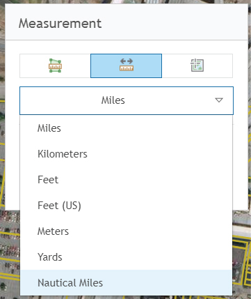
measurement._distanceUnitStrings = ["Miles", "Kilometers", "Meters"];
measurement._distanceUnitStringsLong = ["esriMiles", "esriKilometers", "esriMeters"];
});
</script>
</head>
<body class="calcite">
<div id="mainWindow" data-dojo-type="dijit/layout/BorderContainer" data-dojo-props="design:'headline',gutters:false"
style="width:100%; height:100%;">
<div id="map" data-dojo-type="dijit/layout/ContentPane" data-dojo-props="region:'center'">
<div style="position:absolute; right:20px; top:10px; z-Index:999;">
<div id="titlePane" data-dojo-type="dijit/TitlePane" data-dojo-props="title:'Measurement', closable:false">
<div id="measurementDiv"></div>
<span style="font-size:smaller;padding:5px 5px;">Press <b>CTRL</b> to enable snapping.</span>
</div>
</div>
</div>
</div>
</body>
</html>
2 Replies
08-14-2017
12:37 PM
- Mark as New
- Bookmark
- Subscribe
- Mute
- Subscribe to RSS Feed
- Permalink
- Report Inappropriate Content
Andrei,
Sure here is a sample for both of those:
<!DOCTYPE html>
<html>
<head>
<meta http-equiv="Content-Type" content="text/html; charset=utf-8">
<meta name="viewport" content="initial-scale=1, maximum-scale=1,user-scalable=no">
<title>Measure Tool</title>
<link rel="stylesheet" href="https://js.arcgis.com/3.21/esri/themes/calcite/dijit/calcite.css">
<link rel="stylesheet" href="https://js.arcgis.com/3.21/esri/themes/calcite/esri/esri.css">
<style>
html,body {
height:100%;
width:100%;
margin:0;
}
body {
background-color:#FFF;
overflow:hidden;
font-family:"Trebuchet MS";
}
#map {
border:solid 2px #808775;
-moz-border-radius:4px;
-webkit-border-radius:4px;
border-radius:4px;
margin:5px;
padding:0px;
}
#titlePane{
width:280px;
}
</style>
<script src="https://js.arcgis.com/3.21/"></script>
<script>
var map;
require([
"dojo/dom",
"esri/Color",
"dojo/keys",
"dojo/parser",
"dojo/query",
"esri/config",
"esri/sniff",
"esri/map",
"esri/SnappingManager",
"esri/dijit/Measurement",
"esri/layers/FeatureLayer",
"esri/renderers/SimpleRenderer",
"esri/tasks/GeometryService",
"esri/symbols/SimpleLineSymbol",
"esri/symbols/SimpleFillSymbol",
"esri/dijit/Scalebar",
"dijit/layout/BorderContainer",
"dijit/layout/ContentPane",
"dijit/TitlePane",
"dijit/form/CheckBox",
"dojo/domReady!"
], function(
dom, Color, keys, parser, query,
esriConfig, has, Map, SnappingManager, Measurement, FeatureLayer, SimpleRenderer, GeometryService, SimpleLineSymbol, SimpleFillSymbol
) {
parser.parse();
//This sample may require a proxy page to handle communications with the ArcGIS Server services. You will need to
//replace the url below with the location of a proxy on your machine. See the 'Using the proxy page' help topic
//for details on setting up a proxy page.
esriConfig.defaults.io.proxyUrl = "/proxy/";
esriConfig.defaults.io.alwaysUseProxy = false;
//This service is for development and testing purposes only. We recommend that you create your own geometry service for use within your applications
esriConfig.defaults.geometryService = new GeometryService("https://utility.arcgisonline.com/ArcGIS/rest/services/Geometry/GeometryServer");
map = new Map("map", {
basemap: "satellite",
center: [-85.743, 38.256],
zoom: 17
});
var sfs = new SimpleFillSymbol(
"solid",
new SimpleLineSymbol("solid", new Color([195, 176, 23]), 2),
null
);
var parcelsLayer = new FeatureLayer("https://sampleserver1.arcgisonline.com/ArcGIS/rest/services/Louisville/LOJIC_LandRecords_Louisville/...", {
mode: FeatureLayer.MODE_ONDEMAND,
outFields: ["*"]
});
parcelsLayer.setRenderer(new SimpleRenderer(sfs));
map.addLayers([parcelsLayer]);
//dojo.keys.copyKey maps to CTRL on windows and Cmd on Mac., but has wrong code for Chrome on Mac
var snapManager = map.enableSnapping({
snapKey: has("mac") ? keys.META : keys.CTRL
});
var layerInfos = [{
layer: parcelsLayer
}];
snapManager.setLayerInfos(layerInfos);
var measurement = new Measurement({
map: map
}, dom.byId("measurementDiv"));
measurement.startup();
//remove tooltips
query(".esriMeasurement .dijitButtonContents").forEach(function(node){
node.title = "";
});
//adjust distince units drop down list
measurement._distanceUnitStrings = ["Miles", "Kilometers", "Meters"];
measurement._distanceUnitStringsLong = ["esriMiles", "esriKilometers", "esriMeters"];
});
</script>
</head>
<body class="calcite">
<div id="mainWindow" data-dojo-type="dijit/layout/BorderContainer" data-dojo-props="design:'headline',gutters:false"
style="width:100%; height:100%;">
<div id="map" data-dojo-type="dijit/layout/ContentPane" data-dojo-props="region:'center'">
<div style="position:absolute; right:20px; top:10px; z-Index:999;">
<div id="titlePane" data-dojo-type="dijit/TitlePane" data-dojo-props="title:'Measurement', closable:false">
<div id="measurementDiv"></div>
<span style="font-size:smaller;padding:5px 5px;">Press <b>CTRL</b> to enable snapping.</span>
</div>
</div>
</div>
</div>
</body>
</html>
08-15-2017
04:16 AM
- Mark as New
- Bookmark
- Subscribe
- Mute
- Subscribe to RSS Feed
- Permalink
- Report Inappropriate Content
Working great, thank you Robert !