- Home
- :
- All Communities
- :
- Products
- :
- Imagery and Remote Sensing
- :
- Imagery Questions
- :
- Mosaic dataset performance for basic licence level
- Subscribe to RSS Feed
- Mark Topic as New
- Mark Topic as Read
- Float this Topic for Current User
- Bookmark
- Subscribe
- Mute
- Printer Friendly Page
Mosaic dataset performance for basic licence level
- Mark as New
- Bookmark
- Subscribe
- Mute
- Subscribe to RSS Feed
- Permalink
- Report Inappropriate Content
Hi All,
I am looking into the use of mosaic datasets for a large number of image tiles. I know I need at least the standard licence level to create mosaic datasets, but I would like to understand how a basic licence user will be able to use the mosaic dataset. I understand it is read-only for basic licence level users, but I'm not sure whether the functions (e.g. for on-the-fly slope rendering, etc.) will still work.
Can anyone help answer these questions please? Or does anyone have a sample mosaic dataset they could share or point me to, so I can trial it myself.
Many thanks,
David
Solved! Go to Solution.
Accepted Solutions
- Mark as New
- Bookmark
- Subscribe
- Mute
- Subscribe to RSS Feed
- Permalink
- Report Inappropriate Content
Here something to try that shows VERY VERY FEW of the possibilities but is also advanced at the same time:
Find attached a small zip. Please extract to c:\temp .. important to make it work without changes.
It is a 10m resolution dataset, OGD for the whole of Austria.
This mosaic does come with some pre-rendered overviews but it does not contain the raw data. The raw data is on Amazon and will be cached as soon as you request some part of it! So be patient when you zoom in ...
Add the Mosaic to ArcMap (I assume?). The default you see is a plain elevation type of display. I also added three predefined function templates for you to open. Proceed like this:
In ArcMap open layer properties of Image Sub-Layer. Go to Processing Templates Tab and start by selecting "Hillshade" and apply. This will display the Raster as a Standard ArcGIS Hillshade. The fun stuff with functions is, that you can pass arguments to them. See this screenshot: If you name a property ZFactor_1 and change the value and apply - the display will change. So as an end-suer you can have access to settings of a function template if wanted ...

The second function included is "Slope in classes" which shows that a classification can be handed over to the mosaic. It is done by a colormap (also part of the zip) and will be reflected in the TOC
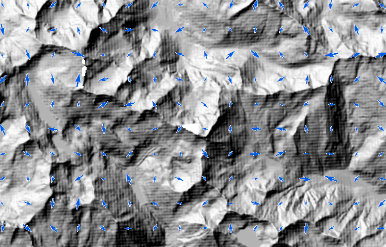
The third example uses this dataset twice as input to a vector field renderer function.Please zoom in considerably, probably double up the layer and make the hillshade-view your "basemap". Then with the vector field you'll see sort of "decination vectors" created from slope and direction.
Will look something like this when applied as described.
And remember to be patient when zooming in ... data will be fetched from Amazon.
With local real data in appropriate formats, mosaics are FAST 🙂
Regards and hope that helps
Guenter
- Mark as New
- Bookmark
- Subscribe
- Mute
- Subscribe to RSS Feed
- Permalink
- Report Inappropriate Content
Here something to try that shows VERY VERY FEW of the possibilities but is also advanced at the same time:
Find attached a small zip. Please extract to c:\temp .. important to make it work without changes.
It is a 10m resolution dataset, OGD for the whole of Austria.
This mosaic does come with some pre-rendered overviews but it does not contain the raw data. The raw data is on Amazon and will be cached as soon as you request some part of it! So be patient when you zoom in ...
Add the Mosaic to ArcMap (I assume?). The default you see is a plain elevation type of display. I also added three predefined function templates for you to open. Proceed like this:
In ArcMap open layer properties of Image Sub-Layer. Go to Processing Templates Tab and start by selecting "Hillshade" and apply. This will display the Raster as a Standard ArcGIS Hillshade. The fun stuff with functions is, that you can pass arguments to them. See this screenshot: If you name a property ZFactor_1 and change the value and apply - the display will change. So as an end-suer you can have access to settings of a function template if wanted ...
The second function included is "Slope in classes" which shows that a classification can be handed over to the mosaic. It is done by a colormap (also part of the zip) and will be reflected in the TOC
The third example uses this dataset twice as input to a vector field renderer function.Please zoom in considerably, probably double up the layer and make the hillshade-view your "basemap". Then with the vector field you'll see sort of "decination vectors" created from slope and direction.
Will look something like this when applied as described.
And remember to be patient when zooming in ... data will be fetched from Amazon.
With local real data in appropriate formats, mosaics are FAST 🙂
Regards and hope that helps
Guenter
- Mark as New
- Bookmark
- Subscribe
- Mute
- Subscribe to RSS Feed
- Permalink
- Report Inappropriate Content
Guenter, fantastic reply, very helpful, thank you very much
David