- Home
- :
- All Communities
- :
- Products
- :
- Mapping
- :
- Mapping Questions
- :
- ARCVIEW
- Subscribe to RSS Feed
- Mark Topic as New
- Mark Topic as Read
- Float this Topic for Current User
- Bookmark
- Subscribe
- Mute
- Printer Friendly Page
ARCVIEW
- Mark as New
- Bookmark
- Subscribe
- Mute
- Subscribe to RSS Feed
- Permalink
- Report Inappropriate Content
HI,
I have been asked to provide some data that can be read in GIS (ARCVIEW). Is it not reading a regular .gdb data?
If not, any suggestion? What I have is just an .gdb. Can I convert the data in some how?
Many thanks,
F
- Mark as New
- Bookmark
- Subscribe
- Mute
- Subscribe to RSS Feed
- Permalink
- Report Inappropriate Content
If you have ArcMap (Standard/Advanced license), you could export the data from File Geodatabase (*.gdb) to shapefiles. ArcView should be able to read shapefiles.
Think Location
- Mark as New
- Bookmark
- Subscribe
- Mute
- Subscribe to RSS Feed
- Permalink
- Report Inappropriate Content
Thanks. do you know what about the raster I have in my .gdb?How can I export?
Cheers
F
- Mark as New
- Bookmark
- Subscribe
- Mute
- Subscribe to RSS Feed
- Permalink
- Report Inappropriate Content
Open the respective image in ArcMap > Right-click the layer > Export.
Save the raster in a basic folder (not in a geodatabase) in either *.tif or *.img format.
FAQ: What are all the file extensions related to ArcView?
Think Location
- Mark as New
- Bookmark
- Subscribe
- Mute
- Subscribe to RSS Feed
- Permalink
- Report Inappropriate Content
Thanks. I have tried to follow the instruction in the provided link, but when I try to export, it seems the only way it saves it is .dbf so it doesn't make the job 
F
- Mark as New
- Bookmark
- Subscribe
- Mute
- Subscribe to RSS Feed
- Permalink
- Report Inappropriate Content
A DBF option will come when you are saving a table. Are you sure you are exporting the Raster data? Could you provide screenshots?
Think Location
- Mark as New
- Bookmark
- Subscribe
- Mute
- Subscribe to RSS Feed
- Permalink
- Report Inappropriate Content
So it is a Side scan sonar raster. Please see below
.png)
- Mark as New
- Bookmark
- Subscribe
- Mute
- Subscribe to RSS Feed
- Permalink
- Report Inappropriate Content
What version of ArcMap are you using? I am getting the following options of saving the Raster in following formats when my output location is a basic folder. I am using ArcMap 10.1.
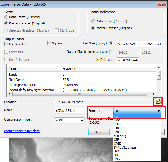
Think Location
- Mark as New
- Bookmark
- Subscribe
- Mute
- Subscribe to RSS Feed
- Permalink
- Report Inappropriate Content
Try converting Raster Catalog to Raster Dataset. Save it with .tif or .img extension.
Think Location
- Mark as New
- Bookmark
- Subscribe
- Mute
- Subscribe to RSS Feed
- Permalink
- Report Inappropriate Content
ArcMap 10.2. How bizarre is this?