- Home
- :
- All Communities
- :
- Products
- :
- Mapping and Charting Solutions
- :
- Mapping and Charting Questions
- :
- Scallop Shaped Edges on Interpolation
- Subscribe to RSS Feed
- Mark Topic as New
- Mark Topic as Read
- Float this Topic for Current User
- Bookmark
- Subscribe
- Mute
- Printer Friendly Page
Scallop Shaped Edges on Interpolation
- Mark as New
- Bookmark
- Subscribe
- Mute
- Subscribe to RSS Feed
- Permalink
- Report Inappropriate Content
I am trying to use Natural Neighbor Interpolation on a set nodes (100,000's) to create a raster surface that has a grid resolution of 1x1 meter. When I symbolize the raster to be n=0 clear, and n>0 my specific color ramp I created, the edge of the n>0 extent is scallop shaped. Is anyone familiar with this and know how to solve this without using 3D analyst?
- Mark as New
- Bookmark
- Subscribe
- Mute
- Subscribe to RSS Feed
- Permalink
- Report Inappropriate Content
"scallop shaped".
??
Can you show us a picture of what you mean?
- Mark as New
- Bookmark
- Subscribe
- Mute
- Subscribe to RSS Feed
- Permalink
- Report Inappropriate Content
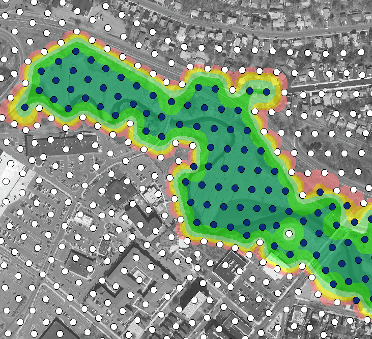
I posted a picture!
- Mark as New
- Bookmark
- Subscribe
- Mute
- Subscribe to RSS Feed
- Permalink
- Report Inappropriate Content
But what is the problem with what you have got?
The raster interp seems to be doing exactly what is required.
I take it that the white dots have very low values of whatever it is you are measuring and the blue dots are higher values.
- Mark as New
- Bookmark
- Subscribe
- Mute
- Subscribe to RSS Feed
- Permalink
- Report Inappropriate Content
The scallop or bubble shape in between the white dots. White dots are 0 and the blue is anywhere between 1 and 100. Because of the NNI, there is some excess interpolation out to the white dots. So between the Blue and white dots there is data that doesn't actually naturally occur. We to get rid of the "scallop shape".
- Mark as New
- Bookmark
- Subscribe
- Mute
- Subscribe to RSS Feed
- Permalink
- Report Inappropriate Content
I think you are expecting "interpolation" to do something it is not designed to do. It will interpolate between low and high depending on the decay function.
So, if you do not think this is "real", do as Dan_Patterson says, make a clip polygon and clip out the bit that you "like".
- Mark as New
- Bookmark
- Subscribe
- Mute
- Subscribe to RSS Feed
- Permalink
- Report Inappropriate Content
- Mark as New
- Bookmark
- Subscribe
- Mute
- Subscribe to RSS Feed
- Permalink
- Report Inappropriate Content
If you have a grid resolution of 1 m... there is no need to interpolate, just convert to raster using a cell size of 1.5 or 2. You are going to get no extra 'precision' doing an interpolation, as your data is suggesting
- Mark as New
- Bookmark
- Subscribe
- Mute
- Subscribe to RSS Feed
- Permalink
- Report Inappropriate Content
Our point feature class shape file is not a 1 m grid. We want to interpolate to a 1 meter grid. The problem lies in the scallop shape interpolated edge between the Blue dots and the white (0's) dots. The green yellow and red raster is showing the issue.
- Mark as New
- Bookmark
- Subscribe
- Mute
- Subscribe to RSS Feed
- Permalink
- Report Inappropriate Content
It is the data spread then as Neil suggests. if you don't want the scalloped edges, then you would have to clip around a bounding extent