- Home
- :
- All Communities
- :
- Products
- :
- Mapping
- :
- Map Projections Questions
- :
- Projecting Vectors in LO19 projection to MODIS sin...
- Subscribe to RSS Feed
- Mark Topic as New
- Mark Topic as Read
- Float this Topic for Current User
- Bookmark
- Subscribe
- Mute
- Printer Friendly Page
Projecting Vectors in LO19 projection to MODIS sinusoidal Projection
- Mark as New
- Bookmark
- Subscribe
- Mute
- Subscribe to RSS Feed
- Permalink
- Report Inappropriate Content
Hi Everyone
I have a case where I have vector data (crop census polygons) in a LO19_South Africa Projected Coordinate System with a Geographic Coordinate Sytem of Hartebeesthoek_1994. I then added MODIS LST data to my dataframe which has a Projected Coordinate System which reads: Unknown_datum_based_upon_the_custom_spheroid_Sinusoidal (in layer properties) and GCS Unknown_datum_based_upon_the_custom_spheroid (according to the layer properties) with datum: Not_specified_based_on_custom_spheroid (according to layer properties).
When the data frame CS is the same as the MODIS data then the MODIS data displays correctly. When I change the data frame CS to the crop census polygon CS then the MODIS data displays skew and the polygons correct. With the data frame with the MODIS data CS, I then created a Grid Index with the same coordinates system as the MODIS data so that it fits perfectly.
However I want to do area calculations using the Grid that I created with a MODIS/Sinusoidal Projection and the crop census data which has a LO19 projection.
I assume that both shapefiles need to be in the same coordinate system for the calculations to be accurate. Now my question now is how do I get the Grid(Sinusoidal Projection) into a LO19 Projection or visa versa.
I have tried the projection tool but it doesn't seem to work due to transformation issues.
Can anyone please assist me with this problem? Any advice would be much appreciated.
Kind Regards
Gulu
- Mark as New
- Bookmark
- Subscribe
- Mute
- Subscribe to RSS Feed
- Permalink
- Report Inappropriate Content
When you say "LO 19", you probably mean a normal Transverse Mercator centered on Long 19E. Based on Hart94.
Hart94 is functionally equivalent to WGS84 so there should be no "transformation issues" between the satellite data and your crop data.
Could you post some snapshots of the properties page - CS and extents for both please.
- Mark as New
- Bookmark
- Subscribe
- Mute
- Subscribe to RSS Feed
- Permalink
- Report Inappropriate Content
Hi Neil
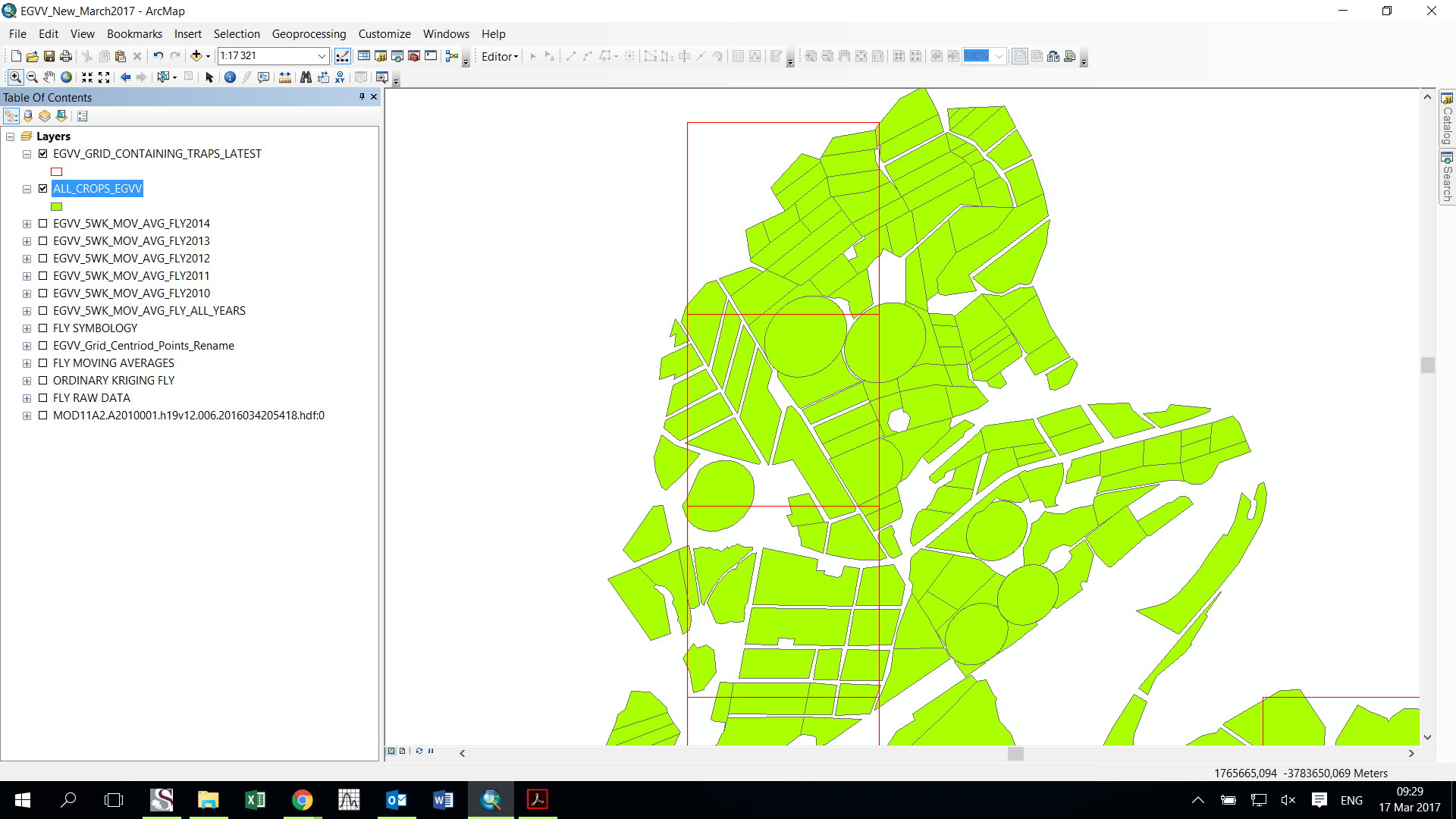
You are correct in what you said in the above. Please see below my data. The green is the crop census data with LO19 projection and the red squares are the grid (Sinusoidal projection) created form the MODIS data.
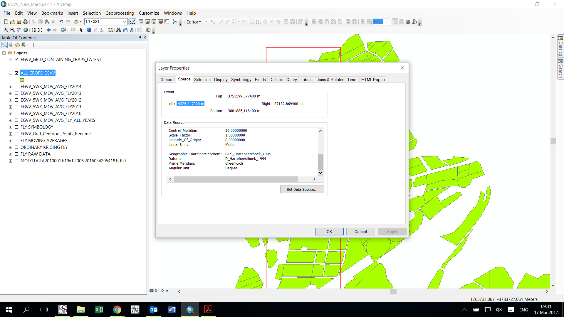
The properties of Crop census polygons

The properties of Grid Index Layer

Thank you in advance for your help.
Kind Regards
Gulu
- Mark as New
- Bookmark
- Subscribe
- Mute
- Subscribe to RSS Feed
- Permalink
- Report Inappropriate Content
Sorry, but where are the red square polygons coming from?
Are they the 1km(?) pixel outlines from the modis data?
I can't get much info from noaa on the details of the CS for modis.
If you are projecting from Modis CS to "Lo19", you may want to densify those polygons a bit.
And you need to specify a bit better the actual projection of the modis data.
Is that poorly defined CS exactly as it was when downloaded?
- Mark as New
- Bookmark
- Subscribe
- Mute
- Subscribe to RSS Feed
- Permalink
- Report Inappropriate Content
The red squares polygons is a Grid index created using the cell size, coordinate system and extent of the MODIS data. And yes the Poorly defined CS is exactly at it was when it was downloaded.
This is the properties for the Grid Index Polygons which is exactly the same as the downloaded MODIS data CS
Data Type: Shapefile Feature Class
Shapefile: E:\Academic\ArcGIS_File_Geodatabases\EGVV Project @017\EGVV_GRID_CONTAINING_TRAPS_LATEST.shp
Geometry Type: Polygon
Coordinates have Z values: No
Coordinates have measures: Yes
Projected Coordinate System: Unknown_datum_based_upon_the_custom_spheroid_Sinusoidal
Projection: Sinusoidal
false_easting: 0,00000000
false_northing: 0,00000000
central_meridian: 0,00000000
Linear Unit: Meter
Geographic Coordinate System: GCS_Unknown_datum_based_upon_the_custom_spheroid
Datum: D_Not_specified_based_on_custom_spheroid
Prime Meridian: Greenwich
Angular Unit: Degree
- Mark as New
- Bookmark
- Subscribe
- Mute
- Subscribe to RSS Feed
- Permalink
- Report Inappropriate Content
To project the modis grid you can use the project tool in the data management / projections and transformations tool box.
Or even easier, you can just export the layer out of ArcMap. If the coordinate system of the data frame is "Lo19", check "use coord sys of dataframe".
A word of warning. That path to your data is rather convoluted and has spaces and other funny stuff in it like "@". Rather make the path to your data a bit simpler and do not have any funny stuff in the path. Some tools fail when given paths like that. Also the path says ...filegeodatabases, but the actual file is a shapefile???.
Why not make a file geodb and put the data in that.
You may want to redefine the GCS / Datum of the Modis data. I have to presume that this should be GCS_WGS84.
In ArcCatalog, navigate to the file, right click to get the properties page, right click the coord sys definition and select "Copy & Modify", make sure you give it a meaningful name and change the GCS to WGS84.