- Home
- :
- All Communities
- :
- Products
- :
- Mapping
- :
- Mapping Questions
- :
- 'Zoom Extents' zooms to infinity on Polygon Featur...
- Subscribe to RSS Feed
- Mark Topic as New
- Mark Topic as Read
- Float this Topic for Current User
- Bookmark
- Subscribe
- Mute
- Printer Friendly Page
'Zoom Extents' zooms to infinity on Polygon Feature Class
- Mark as New
- Bookmark
- Subscribe
- Mute
- Subscribe to RSS Feed
- Permalink
- Report Inappropriate Content
Hi All,
I have a polygon feature class of properties in our local city, and if I zoom to extents on this particular feature class it zooms right out to the never never, so I am assuming I have some rogue parcel of land drawn in.
So I thought that if I select ALL parcels in my local city, open attribute table, and then invert my selection, it should show me the trouble parcel, but it does not show any selections at all... I am stumped as to how to clean this up.
Anyone got any tips?
This is where I would expect it to zoom extents:
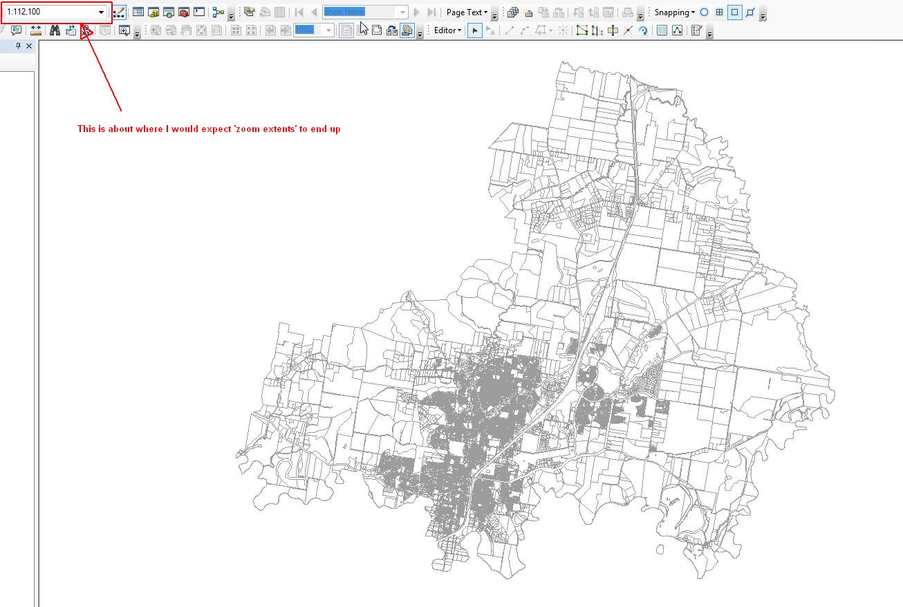
This is what actually happens:
- Mark as New
- Bookmark
- Subscribe
- Mute
- Subscribe to RSS Feed
- Permalink
- Report Inappropriate Content
You have some bad geometry... run the Repair Geometry tool Repair Geometry—Help | ArcGIS Desktop
There is a Check Geometry tool if you want to just check it
- Mark as New
- Bookmark
- Subscribe
- Mute
- Subscribe to RSS Feed
- Permalink
- Report Inappropriate Content
Hi Dan,
Just running that tool I get this error:
ERROR 000314: Database Connections\GISADMIN@SDE_Spatial@SDE-DB.sde\SDE_SPATIAL.GISADMIN.Cadastre\SDE_SPATIAL.GISADMIN.land_parcels_active_region is not a Shapefile or a feature class in a Personal or File Geodatabase.
I did fail to mention this is within our Enterprise GDB.
I am thinking all I would have to do is export this FC to a FileGDB, then run the tool then re-import into the SDE. Do you think this may work?
Cheers
-Ben
- Mark as New
- Bookmark
- Subscribe
- Mute
- Subscribe to RSS Feed
- Permalink
- Report Inappropriate Content
Ben... I only work local and don't do the SDE thing, but it can't hurt to see if that is the issue since you won't be harming the source
- Mark as New
- Bookmark
- Subscribe
- Mute
- Subscribe to RSS Feed
- Permalink
- Report Inappropriate Content
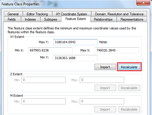
Go to ArcCatalog > Right-click the feature-class > Properties > Feature Extent (tab) > Click "Recalculate". Any change in the extent?
Think Location
- Mark as New
- Bookmark
- Subscribe
- Mute
- Subscribe to RSS Feed
- Permalink
- Report Inappropriate Content
That is interesting, it does indeed update the Min X and Min Y values accordingly. (this dataset is currently locked, so I couldn't save the changes), but it looks like it will do the trick.
In response to Dan Patterson I have exported the data to a shapefile, and have run the check geometry tool and it has found 12 errors to repair. So when I get a chance I will run the Repair Geometry tool to resolve these issues also!
Thanks for your comments.