- Home
- :
- All Communities
- :
- User Groups
- :
- Addressing
- :
- Questions
- :
- How to use an address range value to create a new ...
- Subscribe to RSS Feed
- Mark Topic as New
- Mark Topic as Read
- Float this Topic for Current User
- Bookmark
- Subscribe
- Mute
- Printer Friendly Page
How to use an address range value to create a new record for each address within the range?
- Mark as New
- Bookmark
- Subscribe
- Mute
- Subscribe to RSS Feed
- Permalink
- Report Inappropriate Content
I have a shapefile of parcels which contains an address for each parcel. Some of these addresses are listed as ranges (e.g. 4422-88 Wissahickon Ave). Is there a way to create a new record for each address within that range? I essentially want many addresses associated with a parcel if the parcel contains many addresses. I am assuming it would require the use of a geocoder, but I am not sure how that could be utilized. Any advice would be great!
- Mark as New
- Bookmark
- Subscribe
- Mute
- Subscribe to RSS Feed
- Permalink
- Report Inappropriate Content
Given the range you provide above, how many actual physical addresses are associated with it? Are there 66 (odd and even) or 33 (even only) or some combination? Do you need an actual point for each? If so, yes you'd want to geocode each address. Otherwise you could create a table record of each address by iterating through the range using a cursor in Python, but this is where I hand if off to Dan_Patterson or dkwiens
- Mark as New
- Bookmark
- Subscribe
- Mute
- Subscribe to RSS Feed
- Permalink
- Report Inappropriate Content
I just checked in our online software (not associated with ESRI/ArcGIS), and there are 3 addresses on file within that range. There will obviously be more or less addresses associated with other ranges. Maybe this becomes a question of how I can bring in data from our online system?
- Mark as New
- Bookmark
- Subscribe
- Mute
- Subscribe to RSS Feed
- Permalink
- Report Inappropriate Content
That's why I thought I'd toss that out little tidbit out there; a range of values is often times misleading with respect to actuality. Just a guess, but there should be a way to get a data dump of what you are after from the source itself.
- Mark as New
- Bookmark
- Subscribe
- Mute
- Subscribe to RSS Feed
- Permalink
- Report Inappropriate Content
Yes, with ranges everything is hypothetical. It is tough to create a point layer from ranges, unless you don't care about points that aren't real life addresses.
- Mark as New
- Bookmark
- Subscribe
- Mute
- Subscribe to RSS Feed
- Permalink
- Report Inappropriate Content
I've decided that having points that may not be real life addresses is acceptable for this project. How would I go about using a cursor? I'm alright at Python, but cursors are not my forte.
I also found the following code to add the increments via Field Calculator (either in Desktop or Python):
rec=0 def autoIncrement(): global rec pStart = 1 pInterval = 1 if (rec == 0): rec = pStart else: rec += pInterval return recautoIncrement()
- Mark as New
- Bookmark
- Subscribe
- Mute
- Subscribe to RSS Feed
- Permalink
- Report Inappropriate Content
Hey Shannon,
just a quick question, you mentioned an only software that has all the addresses. What format is this information in?
Tim
- Mark as New
- Bookmark
- Subscribe
- Mute
- Subscribe to RSS Feed
- Permalink
- Report Inappropriate Content
I'm not sure what you mean by "format" of the software, but it is a standalone system that is available with particular credentials. I'm not sure that I can access a list of each address, but it allows you to search for information given block number, parcel number, ID, etc. or any combination of those.
In terms of the actual addresses, I receive data in all formats. Static tables, Oracle database tables, views, so on and so forth. So I would like to have one table containing all addresses and any alias associated with an address.
I'm thinking that a Search Cursor/Insert Cursor can accomplish this (the first task of parsing address ranges into single addresses), but I'm not seeing much on any existing forums.
- Mark as New
- Bookmark
- Subscribe
- Mute
- Subscribe to RSS Feed
- Permalink
- Report Inappropriate Content
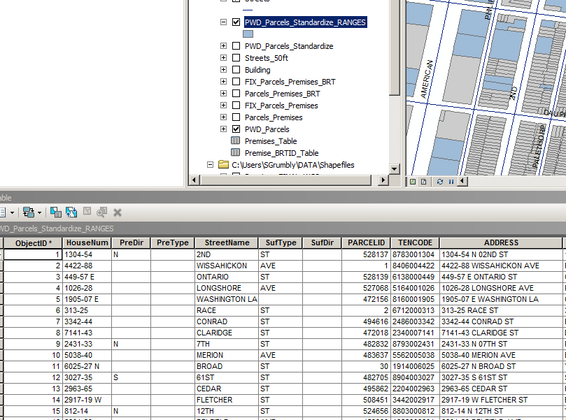
Can you post a screenshot of an example row of your polygon layer?
I hoped that with an export (csv, excel spreadsheet) of the data in your online tool you could geocode those addresses.
- Mark as New
- Bookmark
- Subscribe
- Mute
- Subscribe to RSS Feed
- Permalink
- Report Inappropriate Content
Sure. I used the 'Standardize Address' tool to create the HouseNum, PreDir, PreType, StreetName, SufType, and SufDir fields from 'ADDRESS'. As you can see, it didn't do a perfect job because it left prefix directions with the house number ranges.