- Home
- :
- All Communities
- :
- User Groups
- :
- ArcGIS Desktop Installation Support
- :
- Questions
- :
- Difference accuracy between identify tool and Meas...
- Subscribe to RSS Feed
- Mark Topic as New
- Mark Topic as Read
- Float this Topic for Current User
- Bookmark
- Subscribe
- Mute
- Printer Friendly Page
Difference accuracy between identify tool and Measure tool. (big Problem)
- Mark as New
- Bookmark
- Subscribe
- Mute
- Subscribe to RSS Feed
- Permalink
- Report Inappropriate Content
Hi everybody
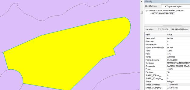
We are facing a very importan issue in our production site, for any particular geometry in our published parcel map (polygon fc) we see different values for shape area. Figure 1 shows a value of 2719.06456 in SHAPE.STArea(). This is from the Identify window.
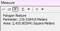
When using the “Measure a Feature” option in the Measure Tool we see a value of 2435.802941.
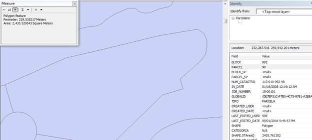
This feature class is generated from a copy of the original parcel map on our production database and as you can see below, it shows an area of approximately 2435.761602 (it also shows a slight difference in the value in the windows but is pretty close).
The published map is created from a spatial view by joining a copy of the production map with a table from our tax database.
Questions:
- Why the slight difference when using the identify tool and the Measure Tool?
- More importantly…Why the different values when comparing the production and the published maps? The Measure Tool looks like is providing the correct value.
This is a big problem for us since we published the area information so our users can analyse assessment values for the properties and compared with the tax system.
Solved! Go to Solution.
Accepted Solutions
- Mark as New
- Bookmark
- Subscribe
- Mute
- Subscribe to RSS Feed
- Permalink
- Report Inappropriate Content
So, this is the main reason:
"the issue you describe, of the areas of parcel polygons in a published map service being incorrect is due to the use of the WGS 1984 Web Mercator projection. The Mercator projection was created for navigation, and preserves direction, but distorts both area and distance a great deal. The illustrations in the Knowledge article at the link below demonstrate distortion that exists in various types of map projections, including Mercator.
http://support.esri.com/Technical-Article/000011356
When using the Measure Tool in ArcMap, if the projection of the ArcMap Data Frame is set to the WGS !984 Web Mercator projection, or to a Geographic Coordinate System (GCS), the Measure Tool automatically defaults to using a Geodesic measurement method, rather than Planar. A Planar measurement treats a distance or area as though it is on a flat surface, but a Geodesic measurement takes into consideration the curvature of the earth, as well as compensating for the stretching that you can see in the Mercator projection, or in a GCS."
- Mark as New
- Bookmark
- Subscribe
- Mute
- Subscribe to RSS Feed
- Permalink
- Report Inappropriate Content
this question in wrong space , please move it.