- Home
- :
- All Communities
- :
- Products
- :
- Mapping and Charting Solutions
- :
- Mapping and Charting Questions
- :
- How do I force Maplex to ignore transparent polygo...
- Subscribe to RSS Feed
- Mark Topic as New
- Mark Topic as Read
- Float this Topic for Current User
- Bookmark
- Subscribe
- Mute
- Printer Friendly Page
How do I force Maplex to ignore transparent polygons, not ignore Data Frames?
- Mark as New
- Bookmark
- Subscribe
- Mute
- Subscribe to RSS Feed
- Permalink
- Report Inappropriate Content
Currently, I'm using Maplex Label Engine in ArcMap to label a map of New York State. It works pretty well so far, but I haven't been able to figure out how to do two things: to get it to ignore the transparent layers, and to not ignore other data frames. I know I can just turn the labels into annotations and place them how I like, but I'm trying to make the production of these maps as automated as possible.
Ignore transparent polygons
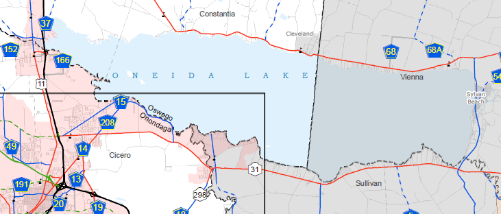
I'm using transparent polygons laid over top of my map to separate regions of the state. You'll see below here with Oneida Lake that the label goes right up to the black boundary of the transparent grey polygon, even though I have things set so it should try to fill the polygon.
I've also tried things like increasing the font size to preposterous levels in orders to make sure that it is regarding the grey polygon boundary as a hard limit. There's no way to get the label to cross the border without making it look ridiculous. I've done everything that I can find within Maplex to force it to cross the boundary. I'll list the settings, maybe someone can point out what I can do better. I think the solution is probably outside of Maplex, though. I just don't know where.
Label Position:
Regular Placement (Don't avoid polygon holes)
Try horizontal position first checked
Position: Curved
Anchor Points: Geometric center of unclipped polygon (then eroded center)
Spread words and characters both checked (infinite limit)
Fitting Strategy:
Stack Label checked
Overrun Feature checked
Strategy order: Reduce label in size, Stack, Compress width, Overrun, Abbreviate
I tried unchecking all these, but that didn't help, and obviously screwed up all my other labels.
Conflict Resolution:
Interior feature weight: 0
Boundary feature weight: 0
Background label checked (or unchecked, nothing changes)
Never remove checked
Don't ignore data frames
I have inset maps laid over my main map in the print layout, as seen below. They are data frames, but as you can see, labels don't seem to give other data frames any regard. LAKE ONTARIO is reduced to ARIO.
It looks like this issue has been brought to ESRI before. I saw one item posted in the Ideas section to just add an item to the Weights section in Conflict Resolution, which sounds like the obvious, easy solution. But in the mean time, is there a less obvious, frustrating solution?
- Mark as New
- Bookmark
- Subscribe
- Mute
- Subscribe to RSS Feed
- Permalink
- Report Inappropriate Content
Re the "don't ignore data frames. AFAIK this is not possible in Arc, as the labelling is determined by elements only within the data frame. Whenever I have had to approach this problem (overlapping data frames and do not want to go down the annotation route) the workaround used has been to position all data frames, then to the base data frame (in your example this would be the one with the Lake Ontario label) to insert a square/rectangular graphic (no fill, no border) to 'shepherd' the labels away from the overlying data frames. A truly horrible clunky workaround but the only one that I have found that works. Another method is to use clipped data frames in which case the data frames are clipped to shapes - the base data frame would have to be clipped to exclude the overlying frames, this would probably be even more horrendous of a workaround and not very manageable to do any frame placement changes.