- Home
- :
- All Communities
- :
- Products
- :
- Geoprocessing
- :
- Geoprocessing Questions
- :
- How to count the number of overlayed bus routes in...
- Subscribe to RSS Feed
- Mark Topic as New
- Mark Topic as Read
- Float this Topic for Current User
- Bookmark
- Subscribe
- Mute
- Printer Friendly Page
How to count the number of overlayed bus routes in ArcMap
- Mark as New
- Bookmark
- Subscribe
- Mute
- Subscribe to RSS Feed
- Permalink
- Report Inappropriate Content
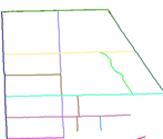
I have a bus route feature where several buses cross the same road. In the image below each route is represented by different colors and there are many overlapping routes which is difficult to show here. My question is how can I show count of bus routes in each street? I don't have spatial analysis licence in my ArcGIS.
I tried several geoprocessing analysis but didn't come with the exact number of bus routes in which each street represents.
Any suggestion please?
- Mark as New
- Bookmark
- Subscribe
- Mute
- Subscribe to RSS Feed
- Permalink
- Report Inappropriate Content
The solution to this is quite simple but it requires you to have the road network as well as your bus route layer. I am assuming from your question that the bus route layer was built along the road network and that your routes can overlap. Your road network, if it is truly a network, will be composed of many polylines each connecting at road junctions.
- Extract the centroids of your road network, so each polyline will have a single point.
- Run a spatial join using ONE TO MANY. You are joining bus routes to centroids.
- The resulting point dataset will have as many centroids at a location as there are intersecting bus routes.
- Run summary stats tool, counting but group by polyline ID which would have been passed over to the centroid.
- Join resulting summary table to road network and symbolize by count.
- Mark as New
- Bookmark
- Subscribe
- Mute
- Subscribe to RSS Feed
- Permalink
- Report Inappropriate Content
Thank you Ducan for your reply.
My bus route is not built along the road network. I will work on building the network first and follow the steps.
Regards,
Almaz
- Mark as New
- Bookmark
- Subscribe
- Mute
- Subscribe to RSS Feed
- Permalink
- Report Inappropriate Content
If you don't have a road network built and just have the bus route layer, a quick partial solution to produce just the overlapping segments that overlap would be this:
1. If your bus routes are in separate feature classes, Merge them into one feature class. Be sure the output has a unique identifier field for each bus route so they can be differentiated.
Merge—Help | ArcGIS for Desktop
2. Run an Intersect on just the combined bus route feature class (i.e. there is only one input - the combined bus route feature class). The resulting feature class will just be the segments that have an overlap. All the segments that were "dropped out" do not overlap (and therefore only have one bus route on them). Of the segments that did show up in the result, if there are only a few, one could individually select each on the map and then check the attribute table to count how many route records are selected in the attribute table.
Intersect - ArcGIS Help (10.2, 10.2.1, and 10.2.2) License note: With ArcGIS for Desktop Basic and Standard licenses, the number of input feature classes or layers is limited to two. So one may have to do several Intersects if one does not have an Advanced license.
Caveat - this assumes the bus route linework is coincident where it overlaps. This is crucial. If the linework is offset by even a small amount in overlap areas, this process will not work correctly. One potential solution if this is an issue is to run the Integrate tool. However, before you do this be sure to back up your data first, as the Integrate tool will alter your source data (it does not create a new output dataset like many other tools do).
Integrate—Help | ArcGIS for Desktop
Chris Donohue, GISP