- Home
- :
- All Communities
- :
- Products
- :
- ArcGIS Spatial Analyst
- :
- ArcGIS Spatial Analyst Questions
- :
- Calculating Correct Slope Values from DEM
- Subscribe to RSS Feed
- Mark Topic as New
- Mark Topic as Read
- Float this Topic for Current User
- Bookmark
- Subscribe
- Mute
- Printer Friendly Page
Calculating Correct Slope Values from DEM
- Mark as New
- Bookmark
- Subscribe
- Mute
- Subscribe to RSS Feed
- Permalink
- Report Inappropriate Content
I projected ASTERDEM (16 bit signed integer with a 1 arc-second resolution) downloaded from USGS EarthExplorer to WGS1984_UTM34N using the project raster tool, and used bilinear interpolation within ArcMap 10.3.1. (After projection, the DEM's linear/horizontal units are in meters (The DEM were downloaded in TIFF format) Then I calculated slope percent using the Spatial Analyst > Surface > Slope tool using percent rise as my output measurement tool. The z factor remained at the default of '1.' I attached a screenshot of the slope results as both the percent values and the visual appear incorrect. Has anyone else had this issue? If so, would you have any suggestions?
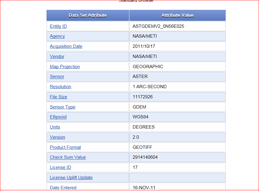
(I attached a screenshot of the metadata from the original ASTERDEM download as well)
- Mark as New
- Bookmark
- Subscribe
- Mute
- Subscribe to RSS Feed
- Permalink
- Report Inappropriate Content
I don't see the problem if you have steep slopes in the area... don't forget a slope of 45 degrees is 100% slope.
So is this out of range of what you would expect? To put yourself at ease, calculate in degrees as a check.
- Mark as New
- Bookmark
- Subscribe
- Mute
- Subscribe to RSS Feed
- Permalink
- Report Inappropriate Content
Thanks for your response, Dan. I ran the slope a second time and calculated in degrees as a check. It still seems as if there may be an interpolation issue--as if there should be more gradations and contours. I attached a screenshot of the slope (noted as Slope2 in the TOC) calculated in degrees and zoomed in this time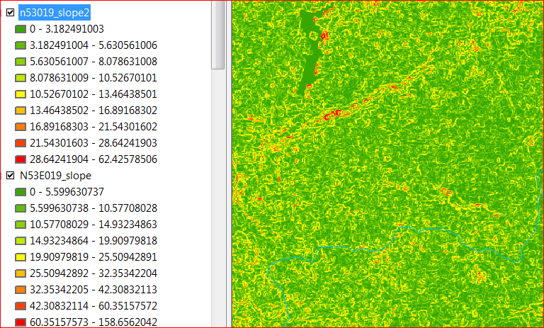 .
.
Could the z value set at the default also be an issue?
- Mark as New
- Bookmark
- Subscribe
- Mute
- Subscribe to RSS Feed
- Permalink
- Report Inappropriate Content
well, your slopes, by whatever measure, are only going to be as good as your DEM. If you produced the DEM by interpolation, this is going to be the controlling factor. If you had far too few points, poorly distributed points and/or used an inappropriate interpolator, then your slope map will suffer. I always check for publically available data before trying to create my own from sampled/surveyed points.