- Home
- :
- All Communities
- :
- Products
- :
- ArcGIS Spatial Analyst
- :
- ArcGIS Spatial Analyst Questions
- :
- Bathymetric Contouring Help
- Subscribe to RSS Feed
- Mark Topic as New
- Mark Topic as Read
- Float this Topic for Current User
- Bookmark
- Subscribe
- Mute
- Printer Friendly Page
Bathymetric Contouring Help
- Mark as New
- Bookmark
- Subscribe
- Mute
- Subscribe to RSS Feed
- Permalink
- Report Inappropriate Content
Hi,
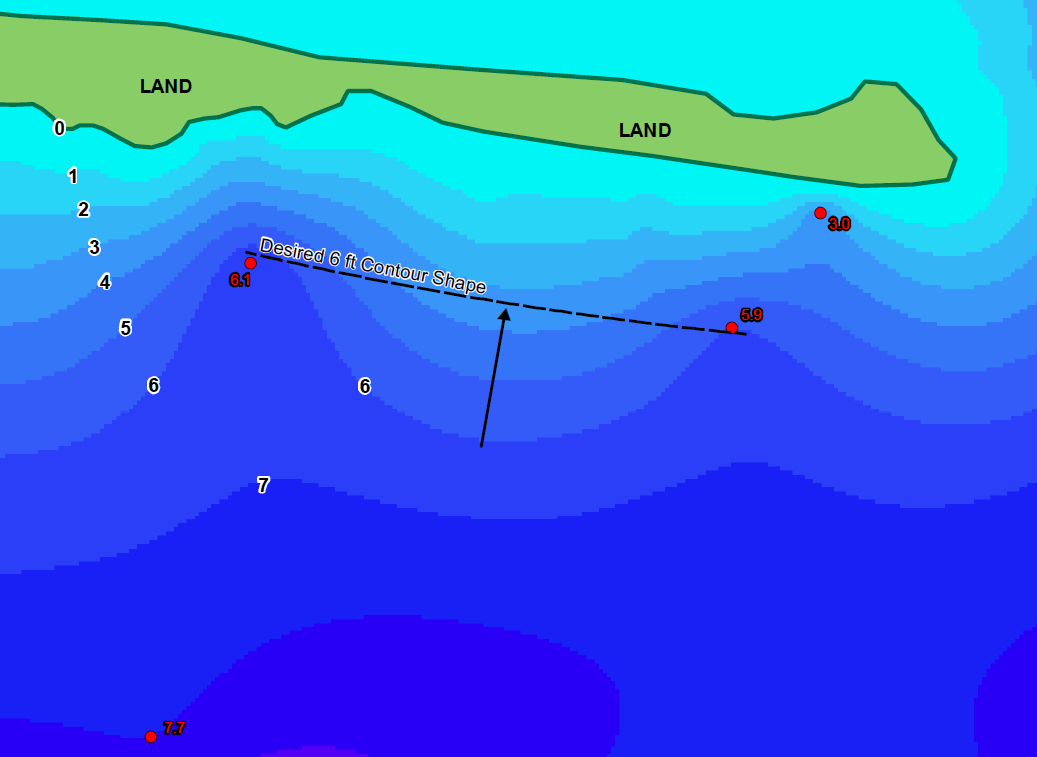
I'm try to create bathymetric contours for a water body but am generating some undesirable features. I know that the bottom slopes away from the shoreline at a consistent angle; however, I keep getting bulbous features between data points. I have tried interpolating with a few different methods (i.e. TINs, IDW, Topo to Raster, and Spline) but keep getting similar results. Below is the output from the Topo to Raster interpolation. I used the point depths (shown in red) and the shoreline as a contour with depth = 0. Is there a better tool or method to refine the bottom surface and make it more closely resemble actual conditions?
Any feedback is greatly appreciated! Thanks
- Mark as New
- Bookmark
- Subscribe
- Mute
- Subscribe to RSS Feed
- Permalink
- Report Inappropriate Content
Sorry, but are you actually trying to interpolate these contours from only 4 points and a zero line? I think the output is pretty good if that is the case.
Interpolation in many cases is quite tricky. If you "know" the contours should be parallel to the coastline, rather than bowing out as they do now, add a couple of extra points yourself.
- Mark as New
- Bookmark
- Subscribe
- Mute
- Subscribe to RSS Feed
- Permalink
- Report Inappropriate Content
I'll second what Neil Ayres said - there is not much data, so there won't be much to interpolate with. Any chance you can get more depth data points? I suspect the "bulbous" result may be due to many zero points (shoreline) versus the few water depths points, as the many zeroes will result in a higher influence over the final result.
Chris Donohue, GISP
- Mark as New
- Bookmark
- Subscribe
- Mute
- Subscribe to RSS Feed
- Permalink
- Report Inappropriate Content
There is no doubt that more points depths equal more accuracy. But if you want to create a DEM from 4 point and make it parallel to the coastline. you can measure a distance to each point from coastline. (you can use Near tool for this propose). Then create Multiple Ring Buffer for the coastline depend on the 4 distance that you get from previous step.
Vertices the for polygons buffer to point with same depth for each polygon .
Use the output feature points to create a perfect DEM.