- Home
- :
- All Communities
- :
- Products
- :
- ArcGIS Pro
- :
- ArcGIS Pro Questions
- :
- hillshade command in arcpy producing odd results
- Subscribe to RSS Feed
- Mark Topic as New
- Mark Topic as Read
- Float this Topic for Current User
- Bookmark
- Subscribe
- Mute
- Printer Friendly Page
hillshade command in arcpy producing odd results
- Mark as New
- Bookmark
- Subscribe
- Mute
- Subscribe to RSS Feed
- Permalink
- Report Inappropriate Content
I have written a stand alone script in python 3.4 that uses ArcPro arcpy to complete various geoprocessing tasks on a list of input DEMs. One of the tasks is a hillshade, which is usually very straightforward. When I run the script (below), I get a very odd result (attached as hillshade1), which defaults to display the hillshade as using the unique categories symbology when you open it in ArcPro. If I switch the symbology to stretched, it appears as expected (attached as hillshade2) so the correct data is there. Also, if I run hillshade in ArcPro using the geoprocessing tools, the results return a stretched default symbology as expected (as in hillshade2 below). I don't see any options in the code for the hillshade command that determine default symbology. In addition, this code ran fine previously as part of a stand alone script with python 2.7 and ArcGIS Desktop. What is the disconnect between running the tool in ArcPro and running it in a stand alone script using python 3.4 and the arcpy package? Is this a bug or is there something I can do in my code? Thanks!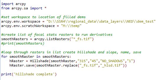
hillshade1
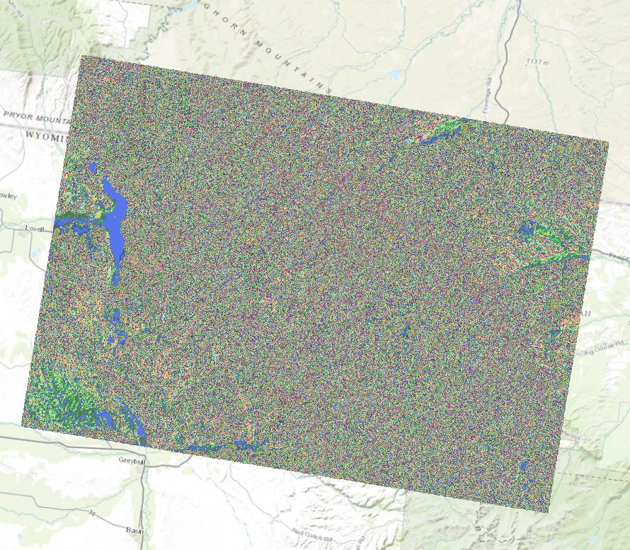
hillshade2
- Mark as New
- Bookmark
- Subscribe
- Mute
- Subscribe to RSS Feed
- Permalink
- Report Inappropriate Content
I saw your last post on this and never got around to check to see if Pro, had the equivalent of the arcmapadvancedsetting.exe utility. It seems like the unique values symbology is set given that the range of values is limited. It might be worthwhile checking for one in the Pro folder structure (I am Pro-less at the moment)