- Home
- :
- All Communities
- :
- Products
- :
- Mapping
- :
- Mapping Questions
- :
- Incomplete list of classes in legend
- Subscribe to RSS Feed
- Mark Topic as New
- Mark Topic as Read
- Float this Topic for Current User
- Bookmark
- Subscribe
- Mute
- Printer Friendly Page
Incomplete list of classes in legend
- Mark as New
- Bookmark
- Subscribe
- Mute
- Subscribe to RSS Feed
- Permalink
- Report Inappropriate Content
Hello and thanks!
I am using ArcMap 10.3.1 and working with vegetation data, ESRI grid format. Until recently I have been able to successfully use the "Only show classes that are visible in the current map extent" feature (legend properties>Items tab>Map Extent Options). Now when I check this option, the legend list is cut off, meaning that only roughly 1/2 of the classes show in the legend. I have attached a screen capture of a legend that does not list all of the legend items, leaving off roughly 1/2 of them.
All ideas appreciated!
Randy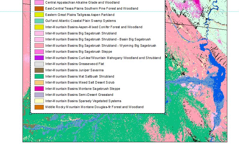
- Mark as New
- Bookmark
- Subscribe
- Mute
- Subscribe to RSS Feed
- Permalink
- Report Inappropriate Content
Hi Randy,
Can you tell if the legend is refreshing itself? Can you force it to refresh? Also, maybe pan the map back and forth to hopefully refresh the active view.
- Mark as New
- Bookmark
- Subscribe
- Mute
- Subscribe to RSS Feed
- Permalink
- Report Inappropriate Content
Many thanks Adrian. No luck. The legend does refresh, but still only shows the first 1/2 or so of the classes.
Any other ideas? Right now I am stuck with clipping the data which is OK but not ideal
Randy
- Mark as New
- Bookmark
- Subscribe
- Mute
- Subscribe to RSS Feed
- Permalink
- Report Inappropriate Content
The data set seems to be very complex. Is it running into a timeout problem in trying to calculate all the unique classes in your extent? What happens when you zoom into a very localized extent?
- Mark as New
- Bookmark
- Subscribe
- Mute
- Subscribe to RSS Feed
- Permalink
- Report Inappropriate Content
Go to your argis folder ie ... C:\Program Files (x86)\ArcGIS\Desktop10.4\Utilities it will depend on version number, and run the AdvancedArcMapSettings.exe You may have exceeded the 25 limit on the number of unique classes a raster can display ... change it to a higher number
- Mark as New
- Bookmark
- Subscribe
- Mute
- Subscribe to RSS Feed
- Permalink
- Report Inappropriate Content
Many thanks Dan and Adrian. I really liked your idea Dan and tried it to no avail. Trying it did force me to pay more attention and while I don't have the pattern totally figured out I did learn that the option does not work period. It seems to pick legend items at random (e.g., there will be items in the legend that are not in the extent). At this point I suspected the dataset, but found it happens with several rasters I tried. Something really weird is happening here!
I have tried several datasets, using different value fields to draw the legend and all sorts of panning and zooming. It's as if the tool will only look at the top half of the attribute table (e.g., it will not move past classes that start with "N", or their associated values). If I zoom out it will keep adding classes to the legend as long as they are not past a certain point in the attribute table.
All help appreciated!
Randy
- Mark as New
- Bookmark
- Subscribe
- Mute
- Subscribe to RSS Feed
- Permalink
- Report Inappropriate Content
how many records in your table?
have you selected the latter half of the table? (either via query or manually)
is there not a simplified classification scheme you can try?
I have a vague recollection about unique classes being limited in number both in raster and vector, I will look more
- Mark as New
- Bookmark
- Subscribe
- Mute
- Subscribe to RSS Feed
- Permalink
- Report Inappropriate Content
Randy,
Do you have access to ArcGIS Pro? I know this may not be the best answer to the issue you're seeing but I have found that layout-view-type issues are vastly improved in Pro. It might be worth looking into.
- Mark as New
- Bookmark
- Subscribe
- Mute
- Subscribe to RSS Feed
- Permalink
- Report Inappropriate Content
Thanks again. Soon I'll be digging back into this but will have to clip the data for now. I hope I can return the favor two you both someday!
Randy