- Home
- :
- All Communities
- :
- User Groups
- :
- Web AppBuilder Custom Widgets
- :
- Questions
- :
- Print Plus tool: Not able to retain map extent in ...
- Subscribe to RSS Feed
- Mark Topic as New
- Mark Topic as Read
- Float this Topic for Current User
- Bookmark
- Subscribe
- Mute
- Printer Friendly Page
Print Plus tool: Not able to retain map extent in the print out
- Mark as New
- Bookmark
- Subscribe
- Mute
- Subscribe to RSS Feed
- Permalink
- Report Inappropriate Content
Thank you for the great tool Larry.
Print Plus Widget Version 1.1.6 July 12, 2015
I am trying to use print plus tool with ArcGIS Server's print default print service. I am on Web AppBuilder 2.0. When I try to use scale slider to adjust the map extent for print out, the print output does not retain the map extent correctly. I have attached the screen shots to illustrate the problem. Not sure if it is a known issue or I have not configured the tool correctly.
Thank you,
- Mark as New
- Bookmark
- Subscribe
- Mute
- Subscribe to RSS Feed
- Permalink
- Report Inappropriate Content
Were you ever able to get this figured out ?
- Mark as New
- Bookmark
- Subscribe
- Mute
- Subscribe to RSS Feed
- Permalink
- Report Inappropriate Content
I found the solution. In printplus.js
Change :
this.printparams.outSpatialReference = this.map.spatialReference;
to this:
this.printparams.outSpatialReference = new esri.SpatialReference({wkid:yourwkid});
You will need to also add
require(["esri/SpatialReference"], function(SpatialReference)
in the appropriate sections.
You will then need to change the size of the page in the config. I went from around 8.5x11 to 11.65x14.8
- Mark as New
- Bookmark
- Subscribe
- Mute
- Subscribe to RSS Feed
- Permalink
- Report Inappropriate Content
Hi Rickey
Thanks for you response. However I am not sure if I understood you response.
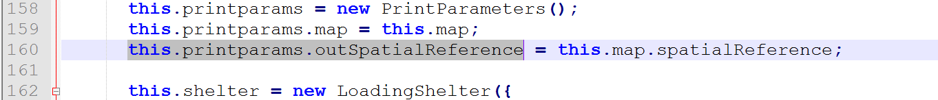
I see that in printplus.js file, on line # 160.
what value you will provide to <yourwkid> ? Is not it same as your map's spatial reference ?
Can you provide some details ?
- Mark as New
- Bookmark
- Subscribe
- Mute
- Subscribe to RSS Feed
- Permalink
- Report Inappropriate Content
- Mark as New
- Bookmark
- Subscribe
- Mute
- Subscribe to RSS Feed
- Permalink
- Report Inappropriate Content
Roger, just an fyi, Larry_Stout switched jobs since he wrote many of his great tools. He's not on geonet as often. Hopefully this will pring him again and he'll see it...but just in case he doesn't, that is why.
- Mark as New
- Bookmark
- Subscribe
- Mute
- Subscribe to RSS Feed
- Permalink
- Report Inappropriate Content
Thanks Rebecca for letting me know. I hope he sees this post early.
- Mark as New
- Bookmark
- Subscribe
- Mute
- Subscribe to RSS Feed
- Permalink
- Report Inappropriate Content
I put in the spatial reference that is local for me and my services. For me that is 2270
So mine looks like this:
this.printparams.outSpatialReference = new esri.SpatialReference({wkid:2270});
Quoting Ben Fousek here:
"If outSpatialReference is not set it uses the map's projection (102100)."
- Mark as New
- Bookmark
- Subscribe
- Mute
- Subscribe to RSS Feed
- Permalink
- Report Inappropriate Content
Thank you Rickey for clarification.
My map uses arcgis online basemap and operational data is also in WGS84 (same coordinate system). hence custom map extent is not getting retained.