- Home
- :
- All Communities
- :
- User Groups
- :
- Cartography and Maps
- :
- Questions
- :
- Can somebody tell me the correct English name of t...
- Subscribe to RSS Feed
- Mark Topic as New
- Mark Topic as Read
- Float this Topic for Current User
- Bookmark
- Subscribe
- Mute
- Printer Friendly Page
Can somebody tell me the correct English name of the small spikes on the contour lines?
- Mark as New
- Bookmark
- Subscribe
- Mute
- Subscribe to RSS Feed
- Permalink
- Report Inappropriate Content
Can somebody tell me the correct English name of the small spikes on the contour lines (isohypse) pointing downhill, showing the steepest direction between two contours? How can I reproduce them in ArcGIS?
Solved! Go to Solution.
Accepted Solutions
- Mark as New
- Bookmark
- Subscribe
- Mute
- Subscribe to RSS Feed
- Permalink
- Report Inappropriate Content
In this document
the "Fallstriche" are called "tags".
- Mark as New
- Bookmark
- Subscribe
- Mute
- Subscribe to RSS Feed
- Permalink
- Report Inappropriate Content
Are you referring to hachures, typically used (in US maps, at least) to indicate depressions in terrain contours? Or are there other kinds of spikes or symbology (like you might see on maps showing fault zones and dips and strikes and such)? If they are simple line hachures or spikes than you could use a hashed line - look at a railroad line style in the Esri stylesets that has a straight "crossbar" for an example of how that is done. You'd just have to make sure the spike fell on the correct side of the line rather than across the line - tip: I think you'd use an offset on the hachure symbol to do that, and would probably need to make sure the direction of the line went the right way for each case. Another option might be to use a picture marker or character marker on a line in the case of "spikes" that aren't a simple short straight line. And a third option could be to use representations symbology, but that gets more complicated if you're not familiar with that functionality (lots of power and user options, but more complex, too).
- Mark as New
- Bookmark
- Subscribe
- Mute
- Subscribe to RSS Feed
- Permalink
- Report Inappropriate Content
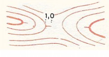
I’d like to know the name of these spikes (see attached images below). There is only one or two on the contour (marked with “1.0”). These spikes helps to clarify uncertainties—whether the slope points upwards or downwards. It could be used not only for depressions (like hachures does) but in all cases of uncertainties. For example the second image—without these spikes—could be a saddle or a ridge too. But the spikes help to clarify that the central part is—actually—lower so it’s a negative feature on the terrain. This technique is may be not used by the cartographers in the US.

Reproducing them in ArcGIS is not only a simple symbology or representation question. It’s much more complicated  .
.
- Mark as New
- Bookmark
- Subscribe
- Mute
- Subscribe to RSS Feed
- Permalink
- Report Inappropriate Content
Thanks for the clarification! Those I am not familiar with. I don't know how you could create them either; maybe as features? Hopefully someone else knows better and will provide an answer!
- Mark as New
- Bookmark
- Subscribe
- Mute
- Subscribe to RSS Feed
- Permalink
- Report Inappropriate Content
I already found the German name: these are the “Fallstriche”. (http://www.o-l.ch/karten/isom/331ch.htm Figure 104) I’ll ask the UK and the German user group for this mysterious name.
- Mark as New
- Bookmark
- Subscribe
- Mute
- Subscribe to RSS Feed
- Permalink
- Report Inappropriate Content
In this document
the "Fallstriche" are called "tags".
- Mark as New
- Bookmark
- Subscribe
- Mute
- Subscribe to RSS Feed
- Permalink
- Report Inappropriate Content
Thanks Marianne! (Oder ich sollte „Danke“ sagen?)
With this help I found the complete list:
“Fallstriche” (German) = “Slope line” (English) = “Eséstüske” (Hungarian) = “Trattino di pendenza” (Italian) = “Spádnice” (Czech) = “Tiret de pente” (French).
- Mark as New
- Bookmark
- Subscribe
- Mute
- Subscribe to RSS Feed
- Permalink
- Report Inappropriate Content
In English this is a Reentrant.