- Home
- :
- All Communities
- :
- Products
- :
- Mapping
- :
- Mapping Questions
- :
- Township and Range in Mapbook?
- Subscribe to RSS Feed
- Mark Topic as New
- Mark Topic as Read
- Float this Topic for Current User
- Bookmark
- Subscribe
- Mute
- Printer Friendly Page
Township and Range in Mapbook?
- Mark as New
- Bookmark
- Subscribe
- Mute
- Subscribe to RSS Feed
- Permalink
- Report Inappropriate Content
I am currently trying to build a mapbook and I created a custom grid that fits the area and the land ownership I want to display. I have the neighboring dynamic text along the edge of my map graphic. I need to add in township and range along the edge of the map graphic as well. I cant seem to figure out how to do this. I have a shapefile of the township and range and it is separate from the map index grid. Is there anyway to do this or do I need to merge the two shapfiles together?
- Mark as New
- Bookmark
- Subscribe
- Mute
- Subscribe to RSS Feed
- Permalink
- Report Inappropriate Content
You could use Spatial Join—Help | ArcGIS for Desktop to put the two files together
- Mark as New
- Bookmark
- Subscribe
- Mute
- Subscribe to RSS Feed
- Permalink
- Report Inappropriate Content
Maybe a custom overlay grid, which is a type of grid/graticule in data frame properties. There aren't built-in styles for custom overlay grids as they are based on features, so you'd have to set it up yourself. I've used them for things like time zone maps where I wanted to label the time zones around the edge of the map.
Here's a help topic about them: https://desktop.arcgis.com/en/arcmap/10.3/map/page-layouts/creating-custom-overlay-grids.htm
- Mark as New
- Bookmark
- Subscribe
- Mute
- Subscribe to RSS Feed
- Permalink
- Report Inappropriate Content
The grid/graticule would probably solve my problem, but at work I run GIS off a citrix remote server and I cant seem to find a way to create and save a custom grid style that I can use.
- Mark as New
- Bookmark
- Subscribe
- Mute
- Subscribe to RSS Feed
- Permalink
- Report Inappropriate Content
I don't know anything about using citrix. Do you not have anyplace you can write files to? If you look in the Style Manager do you see a personal style, and if so, is it shown with a yellow folder icon (indicating write access) or gray (indicating read only)? If you don't have a personal style or it's read only can you create a new style in a folder you do have write access to? If you don't have write access anywhere to create a style I'm not sure what you can do, unless someone else has write access to create a style and can give you a style file to use, if you can load a style file onto a location you can access. If you can't even load a style file from someone else then you might be out of luck.
- Mark as New
- Bookmark
- Subscribe
- Mute
- Subscribe to RSS Feed
- Permalink
- Report Inappropriate Content
I finally got it worked out so that I have a location to save to and use once I'm in ArcMap. The issue I'm having now is following the directions on the ArcGIS Desktop help page about using the custom style. Its probably me just making it harder than it needs to be.
- Mark as New
- Bookmark
- Subscribe
- Mute
- Subscribe to RSS Feed
- Permalink
- Report Inappropriate Content
Did you also look at the related topics shown in that topic? Are there specific steps you're having trouble with? Are you stuck on creating the custom overlay grid in the style manager, or in applying it to a data frame, or is something else causing you problems?
- Mark as New
- Bookmark
- Subscribe
- Mute
- Subscribe to RSS Feed
- Permalink
- Report Inappropriate Content
I was able to get the grid to display on the data frame finally, my issue is the labels are not in places that work with what else I have around the map frame. I also have the adjacent grid cells labeled and the labels for the township and range custom grid are displaying over the top. Is there a different way to adjust the labels associated with the custom grid?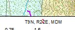
- Mark as New
- Bookmark
- Subscribe
- Mute
- Subscribe to RSS Feed
- Permalink
- Report Inappropriate Content
Unfortunately each grid is independent so there is no conflict detection between them. I won't suggest converting the grid to graphics, which is one way to manipulate them, because you need it live for mapbooks. The only option that comes to mind is to adjust one or the other grid to offset the labels so they don't overlap the labels in the other grid. Maybe offset one set of labels by a negative value so they are inside the map frame.
- Mark as New
- Bookmark
- Subscribe
- Mute
- Subscribe to RSS Feed
- Permalink
- Report Inappropriate Content
Ill have to play with it some more and see what I can get it to do. Thanks for all your help David Barnes!