- Home
- :
- All Communities
- :
- User Groups
- :
- Coordinate Reference Systems
- :
- Questions
- :
- Different layers not lining up on a map
- Subscribe to RSS Feed
- Mark Topic as New
- Mark Topic as Read
- Float this Topic for Current User
- Bookmark
- Subscribe
- Mute
- Printer Friendly Page
Different layers not lining up on a map
- Mark as New
- Bookmark
- Subscribe
- Mute
- Subscribe to RSS Feed
- Permalink
- Report Inappropriate Content
I'm trying to match California addresses to the climate zones in which they're located. I have a shapefile of these climate zones that I got from a CA agency (attached). The shapefile is supposedly in the "NAD_1983_California_Teale_Albers" projection. But when I try to add the latitude and longitudes of the addresses to the map, they show up in the wrong place and at the wrong scale (I'm adding a csv file with the addresses and choosing the "Plot XY data" option). They should be around San Diego, but they appear somewhere east of the Bay Area as one single point.
I've verified that this is not an issue with the address file by double-checking a few coordinates and by using a zip code shape file from another source - in that case, the addresses show up where they should. I can also get the zip code file to line up with the climate zones, but only if I use the "GCS_WGS_1984" projection for the zip code file. It does NOT work if I choose the "NAD_1983_California_Teale_Albers" projection for the zip code file.
I've tried a bunch of different projections and the address points are still not lining up with the climate zones (they move around but never show up in San Diego). At this point, I've exhausted my knowledge of projections. I'm guessing there's an issue with the climate zone file, but I don't know what it is or how to fix it. Any suggestions?
- Mark as New
- Bookmark
- Subscribe
- Mute
- Subscribe to RSS Feed
- Permalink
- Report Inappropriate Content
Being a projected coordinate system, the NAD_1983_California_Teale_Albers projection uses linear units (meters).
I guess the units of the X/Y fields of the CSV files should be in Decimal Degrees (Angular unit). So it should have a geographic coordinate system (GCS_WGS_1984) as its spatial reference.
I suggest you create the points using the table with GCS_WGS_1984.
Once created, you can project them to NAD_1983_California_Teale_Albers using appropriate transformation method (e.g. WGS_1984_(ITRF00)_To_NAD_1983).
Think Location
- Mark as New
- Bookmark
- Subscribe
- Mute
- Subscribe to RSS Feed
- Permalink
- Report Inappropriate Content
I'm guessing that is the problem, but I can't figure out how to do the transformation. I've projected the X/Y points into "NAD_1983_2011_California_Teale_Albers", but the Geographic Coordinate System is still GCS_NAD_1983_2011 (the climate zone file is in GCS_North_American_1983). When I go into the data frame properties to try to define a transformation, I don't see any appropriate options in the dropdown menu for which method to use. And if I pick a random one and click "ok", nothing happens. Do I have to define a transformation myself?
- Mark as New
- Bookmark
- Subscribe
- Mute
- Subscribe to RSS Feed
- Permalink
- Report Inappropriate Content
When Adding XY Data from the CSV (File > Add Data > Add XY Data),
click Edit, filter the spatial reference items with GCS_NAD_1983_2011 and choose NAD 1983 (2011) as the input spatial reference.
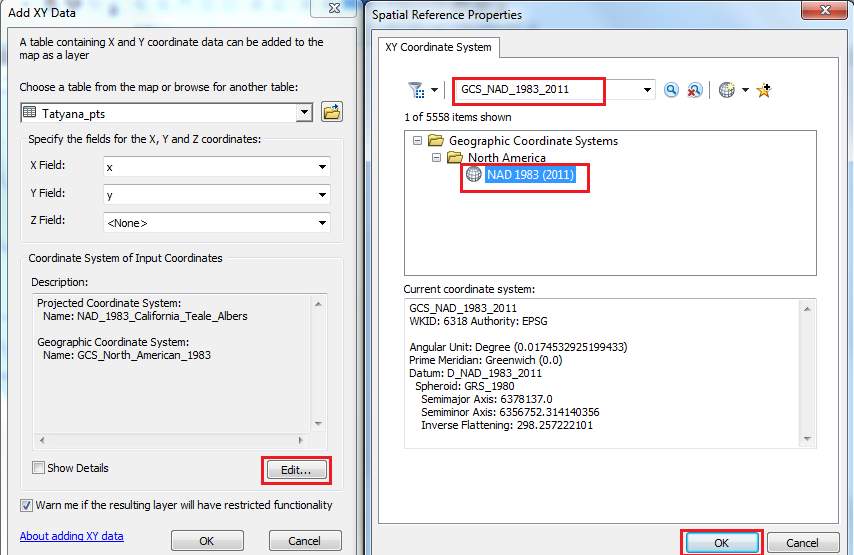
Since the above coordinate system is a GCS, it would take the units as Decimal Degree and plot the points accurately.
If required, you could project it to NAD_1983_2011_California_Teale_Albers if required (No transformation needed).
Project—Data Management toolbox | ArcGIS for Desktop
Think Location
- Mark as New
- Bookmark
- Subscribe
- Mute
- Subscribe to RSS Feed
- Permalink
- Report Inappropriate Content
Thanks, Jayanta! That didn't work either, so I became suspicious given that it probably worked for you with the sample data I provided. It turned out that there were some crazy lag/longs in the big data file (values like 8960 for latitude and 1006 for longitude). Somehow, that was screwing up ArcGIS no matter what coordinate system I tried to pre-specify. I cleaned the addresses to get rid of clearly incorrect coordinates, and it works now. Posting this in case anyone else ends up with a similar problem!
- Mark as New
- Bookmark
- Subscribe
- Mute
- Subscribe to RSS Feed
- Permalink
- Report Inappropriate Content
The zipped file you posted seems OK. I brought it in and it lines up fairly well with other California data I have from several municipal sources (some of the boundaries are along County lines). It does not appear that the Teale Albers assignment is an issue.
May I suggest that you start a new mxd, then bring in the Climate change file first. This will automatically set the Data Frame properties to the Teale Albers assignment in the shapefile. Then try to Add XY Data the csv file and see if the points come out where expected. If that does not work, let us know how it is off as there are several places where things can go awry.
Chris Donohue, GISP
- Mark as New
- Bookmark
- Subscribe
- Mute
- Subscribe to RSS Feed
- Permalink
- Report Inappropriate Content
That didn't work, unfortunately. It might indeed be a units issue, as discussed above, but I haven't figured out how to solve it. Here are examples of about 1,000 coordinates that I'm trying to map. These should all be in the city of San Diego (I added small random numbers to the latitude/longitude to avoid disclosing exact locations).
- Mark as New
- Bookmark
- Subscribe
- Mute
- Subscribe to RSS Feed
- Permalink
- Report Inappropriate Content
I finally figured it out - it was crazy values of lat/long in the full address file (see above). Thanks for all your help!