- Home
- :
- All Communities
- :
- Products
- :
- ArcGIS Spatial Analyst
- :
- ArcGIS Spatial Analyst Questions
- :
- How do I split a DEM into 4 quadrants with an 100 ...
- Subscribe to RSS Feed
- Mark Topic as New
- Mark Topic as Read
- Float this Topic for Current User
- Bookmark
- Subscribe
- Mute
- Printer Friendly Page
How do I split a DEM into 4 quadrants with an 100 meter overlay and export 4 different files?
- Mark as New
- Bookmark
- Subscribe
- Mute
- Subscribe to RSS Feed
- Permalink
- Report Inappropriate Content
Details- I have USGS DEM (utm 11 NAD 83) and I need to split these into 4 equal quadrants, each with a 100 meter overlap, and export each of these files separately, can this be done? what tools could do this?
Solved! Go to Solution.
Accepted Solutions
- Mark as New
- Bookmark
- Subscribe
- Mute
- Subscribe to RSS Feed
- Permalink
- Report Inappropriate Content
so you want to split it into 4... we will use the clip tool, I am assuming you mixed up East and west
5,020,000
500,000 532,100 => difference = 32,100 / 2 = 16,050
4,960,000
N-S difference = 60,000 / 2 = 30,000
bottom left extent
4,990,100 to give the upper 100 overlap
500,000 516,150 to give the 100 m overlap
4, 960,000
repeat for the other 4 quadrants
- Mark as New
- Bookmark
- Subscribe
- Mute
- Subscribe to RSS Feed
- Permalink
- Report Inappropriate Content
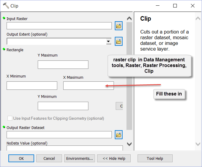
Clip—Help | ArcGIS for Desktop you just have to do the math by setting the correct extent each time, you can control your bounds. There are probably fancier ways but this will be the fastest
- Mark as New
- Bookmark
- Subscribe
- Mute
- Subscribe to RSS Feed
- Permalink
- Report Inappropriate Content
Im not sure what you mean by control your bounds?? Im new to ESRI my bounds are North 5020,000, South 4960,000, East 500,000, West 532,100. How is this done by setting the extent?
- Mark as New
- Bookmark
- Subscribe
- Mute
- Subscribe to RSS Feed
- Permalink
- Report Inappropriate Content
so you want to split it into 4... we will use the clip tool, I am assuming you mixed up East and west
5,020,000
500,000 532,100 => difference = 32,100 / 2 = 16,050
4,960,000
N-S difference = 60,000 / 2 = 30,000
bottom left extent
4,990,100 to give the upper 100 overlap
500,000 516,150 to give the 100 m overlap
4, 960,000
repeat for the other 4 quadrants
- Mark as New
- Bookmark
- Subscribe
- Mute
- Subscribe to RSS Feed
- Permalink
- Report Inappropriate Content
Thank you so much Dan for your help on this, i tried both methods and i liked the clip raster function better. I appreciate your help thanks again
marina
- Mark as New
- Bookmark
- Subscribe
- Mute
- Subscribe to RSS Feed
- Permalink
- Report Inappropriate Content
you are welcome
- Mark as New
- Bookmark
- Subscribe
- Mute
- Subscribe to RSS Feed
- Permalink
- Report Inappropriate Content
or SplitRaster