- Home
- :
- All Communities
- :
- Industries
- :
- Water Resources
- :
- Water Resources Questions
- :
- DEM Reconditioning Question
- Subscribe to RSS Feed
- Mark Topic as New
- Mark Topic as Read
- Float this Topic for Current User
- Bookmark
- Subscribe
- Mute
- Printer Friendly Page
DEM Reconditioning Question
- Mark as New
- Bookmark
- Subscribe
- Mute
- Subscribe to RSS Feed
- Permalink
- Report Inappropriate Content
Hi Everyone, I can't get the DEM reconditioning tool to function, as far as I can tell (I'm new to Arc Hydro). I have a DEM with bridges/culverts, and I need to burn the stream through them. The tool runs and gives me a new "AgreeDEM," which as far as I can tell is exactly the same as the original. I've tried varying the stream buffer and drop/raise values widely, and I always get the same result. Any guidance? Thanks! !
- Mark as New
- Bookmark
- Subscribe
- Mute
- Subscribe to RSS Feed
- Permalink
- Report Inappropriate Content
My first thought is to make sure your processing extents include your area and that your datasets/feature classes all have projections and that they are all the same.
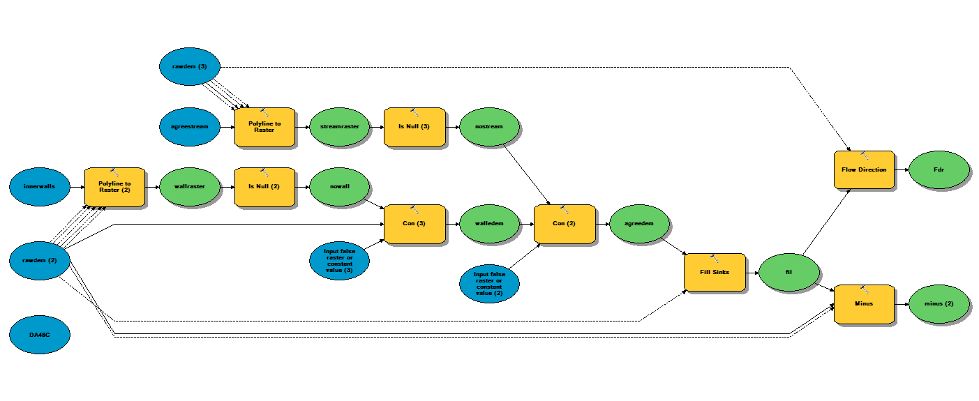
Slightly different note ... I have recently built my own DEM Reconditioning Model Builder model. I've saved it in a toolbox to my desktop and am attaching it. I've also saved it to Python and attached that. I don't know if this site works for sharing a file like this. Let me know if it does. The attached image shows it graphically.
The reason I built it was because the Arc Hydro DEM Reconditioning tools would crash or something.
If you can download the toolbox you should be able to put it in your project directory like any other file. Then in ArcMap you can open the toolbox and edit the model. You will need to rename most of the files since the path is defaulted to the path I am using. This model seems to do the same thing the Arc Hydro tool does and I don't get errors. It doesn't do it as "nicely" as Arc Hydro in that it does not out the output in a "default" folder named after the .mxd or the the data frame.
I have it go all the way to fdr and I have it calculate a "minus" raster. I then symbolize the minus raster in a light blue to dark blue color ramp and set the zero values to no color (null). This lets me see the location and magnitude of the fills and I can check to see if I need to add to my agree stream layer. I have it calculate the fdr raster so I can use the flowpath tool to poke around and make sure things are flowing where I think they should. This is a helpful procedure in urban areas. I tend to iterate through these steps quit a bit before I move on.
If you run the Arc Hydro tools first, certain folders will be created. You can create you own with the geodatabase in your project folder with the same name as the .mxd and the dataset with the same name as the data frame. The rasters go in a folder with the same name as the data frame. After this, I definitely use the Arc Hydro tools for the rest of the process. I haven't gotten into arcpy just yet.
Lastly, I've attached a document I made for myself and future staff who may use Arc Hydro. This has the basic tips on how to setup your Arc Map to avoid errors.
Best,
Mark