- Home
- :
- All Communities
- :
- Products
- :
- ArcGIS Online
- :
- ArcGIS Online Questions
- :
- How to create a clean (faithful) tile cache for ca...
- Subscribe to RSS Feed
- Mark Topic as New
- Mark Topic as Read
- Float this Topic for Current User
- Bookmark
- Subscribe
- Mute
- Printer Friendly Page
How to create a clean (faithful) tile cache for categorical raster data?
- Mark as New
- Bookmark
- Subscribe
- Mute
- Subscribe to RSS Feed
- Permalink
- Report Inappropriate Content
I'm using ArcGIS Desktop tools to create a tile cache for a land cover raster that is intended for upload to ArcGIS Online. Perhaps this is the wrong tool for the job, but Manage Tile Cache (which I've used successfully with image [continuous] data), is making a mess of discrete land cover data. Is there a way to get ArcGIS Desktop to do this without mangling the data?
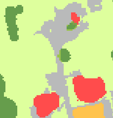
Input land cover data looks like this:
Output tile cache looks like this:
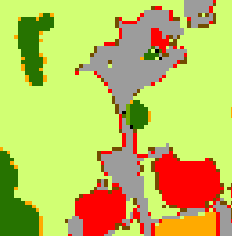
I am using a slightly-modified version of the ArcGIS Online tiling scheme with PNG/compact format. Ideally, the tiles should bear a closer resemblance to the original data. I can live with the slight color changes, but the made-up values around the edges of land cover patches are unacceptable. This is an extremely large raster, so converting to polygons is probably not a viable option.