- Home
- :
- All Communities
- :
- Products
- :
- ArcGIS StoryMaps
- :
- Classic Esri Story Maps Questions
- :
- Story Map Tour from webmap issue
- Subscribe to RSS Feed
- Mark Topic as New
- Mark Topic as Read
- Float this Topic for Current User
- Bookmark
- Subscribe
- Mute
- Printer Friendly Page
Story Map Tour from webmap issue
- Mark as New
- Bookmark
- Subscribe
- Mute
- Subscribe to RSS Feed
- Permalink
- Report Inappropriate Content
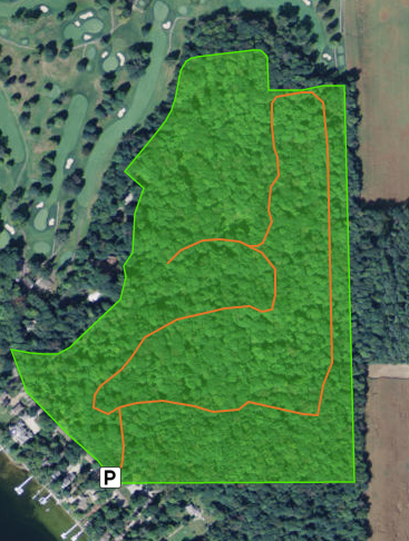
I have a webmap on AGO, creating a simple virtual hike of a nature preserve. http://arcg.is/1W9z5NH
I've made several attempts at creating a Story Map Tour from this webmap, but I keep losing the tour points that I've set up in the webmap.
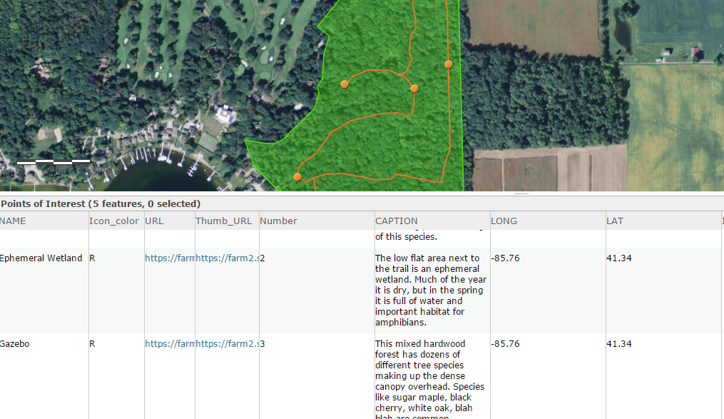
For the tour points in the webmap, I created a feature service, called "Points of Interest", using the story map tour feature class template on GitHub ( map-tour-storytelling-template-js/samples/feature_class at master · Esri/map-tour-storytelling-templ... ) Name, caption, photo urls, colors, lat/long, is all complete for all the tour points.
At this point, I click the share button from the webmap, "create a web app", and then choose the Story Map Tour. When the StoryMap Tour builder opens, the "Points of Interest" layer does not display on the webapp as it does on the webmap.
The Points of Interest layer seems to be correct in the Map Tour settings
but doesn't display any of the points or photos that have been entered in the attribute table on the used in the webmap.
Any thoughts on what I'm doing wrong here?
Needless to say, this is a bare bones story map at this point, until I get the points working.
- Mark as New
- Bookmark
- Subscribe
- Mute
- Subscribe to RSS Feed
- Permalink
- Report Inappropriate Content
Hi Fiona,
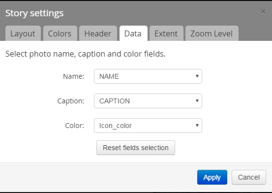
The template you are using from GitHub is pretty old, the most recent I have uses the following field names:
- name
- description
- icon_color
- long
- lat
- pic_url
- thumb_url
- is_video
I would make sure yours match and then see if the Map Tour will recognize your feature layer.
- Mark as New
- Bookmark
- Subscribe
- Mute
- Subscribe to RSS Feed
- Permalink
- Report Inappropriate Content
Changing the fields seemed to make it more confused--it seemed to want "Caption" rather than "Description".
Is there a character limit for text fields for the caption/description? I'd used a file geodatabase/feature class for creating this specifically to have more than 254 characters for the caption field. However, I just did a quick test....exporting my FC as a shapefile and using that data layer instead in my webmap for tour points layer. That seemed to solve the "where are my points" problem when it imported into the storymap.
- Mark as New
- Bookmark
- Subscribe
- Mute
- Subscribe to RSS Feed
- Permalink
- Report Inappropriate Content
The feature service that I created for the tour points on the webmap was very twitchy. I ultimately created a new story map from my webmap, but from a version of the webmap where I had unchecked all the features (preserve boundary, trail, etc) so only the AGO basemap was showing. Since all the extra features of the webmap weren't active, the app builder created its own Tour Map Layer and I just imported my photos from the online photo service. After saving the Story Map Tour, I went back to the webmap, turned back on all my layers and saved the webmap. When I reopened the Story Map, all my features showed up in the basemap. Yay.