- Home
- :
- All Communities
- :
- Products
- :
- Mapping
- :
- Mapping Questions
- :
- High resolution PDF export issues
- Subscribe to RSS Feed
- Mark Topic as New
- Mark Topic as Read
- Float this Topic for Current User
- Bookmark
- Subscribe
- Mute
- Printer Friendly Page
High resolution PDF export issues
- Mark as New
- Bookmark
- Subscribe
- Mute
- Subscribe to RSS Feed
- Permalink
- Report Inappropriate Content
We are creating large maps (24” by 36”) in PDF format that are required to be turned in with a 400 dpi resolution. At this high of a resolution, I am seeing some artifacts that don’t look so great. I have been troubleshooting by exporting a variety of maps with different PDF settings, but so far I have not found a setting that fixes these issues. I have even tried bumping up my Temporary metafile size limit and Output raster buffer size in the Advanced ArcMap settings utility (to 96 and 24, respectively).
Has anyone else seen these artifacts before / does anyone have ideas?
Issue #1: When viewed at 1:1 level (as in the images below), line features over this striped polygon appear ‘broken’. Interestingly, when viewed at 400% level, the lines look fine.
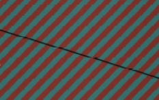
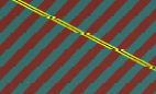
Issue #2: Zooming in on the map (to 400% and 1600%, below), this particular polygon symbol appears to have small triangles missing. There are only supposed to be solid red and blue stripes here.


- Mark as New
- Bookmark
- Subscribe
- Mute
- Subscribe to RSS Feed
- Permalink
- Report Inappropriate Content
the simple documentation and tools followed by the advanced
ExportToPDF—Help | ArcGIS for Desktop
Exporting to Production PDF—Help | ArcGIS for Desktop
I presume that you have gone through these?
There are a number of threads on GeoNet that provide solutions....everyone unique to the case at hand. You seem to have a mix of data types? raster and vector? If so, that may narrow down the issue.
- Mark as New
- Bookmark
- Subscribe
- Mute
- Subscribe to RSS Feed
- Permalink
- Report Inappropriate Content
I was using the ArcPy documentation. I wrote a script to create my test exports.
The Production PDF stuff is new to me, however, I'm not sure I have access to the Production Mapping extension... I put "import arcpyproduction" in my script and got a 'No module' error. My desktop is running ArcGIS 10.2.2. We do have a few machines with 10.3, I'll look into using this when one is available.
We have a good mix of data types on these maps... A raster (photo) basemap, with multiple layers of polygons (7), lines (11), and a few points(2). Plus a few (3) annotation layers for good measure.
It seems a lot of threads I found on GeoNet related to PDF export issues were typically about fonts/marker symbols, or ArcMap getting hung up/crashing. LIke you said, there are a lot of unique issues out there.
I feel like Issue #1 isn't as important, since really all the user has to do is zoom in and see that the lines don't actually look like that.