- Home
- :
- All Communities
- :
- Products
- :
- ArcGIS Collector
- :
- ArcGIS Collector Questions
- :
- Streaming a Freehand 'Polygon'
- Subscribe to RSS Feed
- Mark Topic as New
- Mark Topic as Read
- Float this Topic for Current User
- Bookmark
- Subscribe
- Mute
- Printer Friendly Page
Streaming a Freehand 'Polygon'
- Mark as New
- Bookmark
- Subscribe
- Mute
- Subscribe to RSS Feed
- Permalink
- Report Inappropriate Content
Is there a way, when streaming on the collector app, to make a boundary without straight edges? Is there a parameter I have to place on the shapefile so when it is uploaded to a map it is forced to be freehand? We want to walk a perimeter of an excavated area that does not have straight edges yet the app continues to force it into a polygon. Any suggestions would be appreciated!
- Mark as New
- Bookmark
- Subscribe
- Mute
- Subscribe to RSS Feed
- Permalink
- Report Inappropriate Content
Hi Amanda,
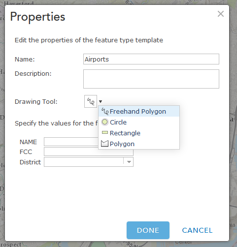
You should be able to set this in the web map. After you click on 'Edit', you should see 'Manage' at the bottom of the Add Features pane. After clicking on Manage, click the dropdown next to the layer > Properties:
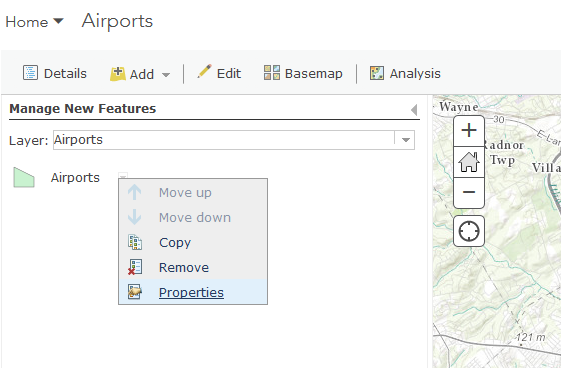
You will then have the ability to set the edit tool:
I believe this will rollover to Collector, but haven't tested it, yet.
- Mark as New
- Bookmark
- Subscribe
- Mute
- Subscribe to RSS Feed
- Permalink
- Report Inappropriate Content
I will try this out! I didn't even think to look for the options in the web map version.
Thanks!
- Mark as New
- Bookmark
- Subscribe
- Mute
- Subscribe to RSS Feed
- Permalink
- Report Inappropriate Content
When you are streaming, vertices are being captured based on a time and distance interval (taking into account how far you have moved, and how long since a vertex has been captured). This will create a polygon, but it should be creating one that matches the boundary of where you are walking. Could you show me a screen shot of what you are seeing in Collector? If you aren't getting as many vertices as you'd like, you can adjust the streaming interval in the settings. This will cause vertices to get added more often. I believe the default is every 5 seconds, but you can make it every second.
- Mark as New
- Bookmark
- Subscribe
- Mute
- Subscribe to RSS Feed
- Permalink
- Report Inappropriate Content
Kylie,
Unfortunately I did not save the test run I did on collector. I changed the streaming interval so hopefully that will help. Next time we use it I will be sure to share it with you.
Thanks for the advice!