- Home
- :
- All Communities
- :
- Products
- :
- ArcGIS Spatial Analyst
- :
- ArcGIS Spatial Analyst Questions
- :
- How to get ‘value’ column of two different raster ...
- Subscribe to RSS Feed
- Mark Topic as New
- Mark Topic as Read
- Float this Topic for Current User
- Bookmark
- Subscribe
- Mute
- Printer Friendly Page
How to get ‘value’ column of two different raster maps in to one (to have both value columns in the attribute table)?
- Mark as New
- Bookmark
- Subscribe
- Mute
- Subscribe to RSS Feed
- Permalink
- Report Inappropriate Content
I have two different raster data at the same resolution.
Data1.tif has the attribute table as follows. Values are just 1,2, and 3.
ODI Value Count
0 1 4565
1 2 1363
2 3 16954
Data2.tif has the attribute table as follows. Values range from 1 to 5000.
ODI Value Count
0 1 68513
1 2 13867
2 3 14368
3 4 678132
4 5 13646
. . .
. . .
. . .
4999 5000 69133
How do I combine this into a new raster map having both the ‘’Value’’ column (from Data1.tif and Data2.tif) as attribute data for the new raster grid? Like
The Newraster.tif should have the attribute table as follows.
ODI Value1 Value2 Count
0 1 1 16
1 2 2 769
2 3 5 41
3 3 67 361
4 1 176 642
5 2 24 78
. . .
. . .
. . .
How can I accomplish this?
- Mark as New
- Bookmark
- Subscribe
- Mute
- Subscribe to RSS Feed
- Permalink
- Report Inappropriate Content
the counts in the combined file don't appear to be associated with either of the inputs. Is there a joinable relationship between the files? either by class or ODI?
- Mark as New
- Bookmark
- Subscribe
- Mute
- Subscribe to RSS Feed
- Permalink
- Report Inappropriate Content
Dear Dan,
The count in the combined file is just a dummy column that I created to ask this question. As I mentioned I want to have an attribute table look something similar to this: ODI Value1 Value2 Count. Each grid in the new file should contain the new OID, with both the value 1, value2 and its count.
There are no joinable relationships between the files (OID or class id, etc) except the long-lat coordinates, that doesn’t appear in the table.
- Mark as New
- Bookmark
- Subscribe
- Mute
- Subscribe to RSS Feed
- Permalink
- Report Inappropriate Content
A portion of the real table would help, since I was totally confused by the lack of association in the data in the hypothetial example. if you want to combine tables in some meaning fashion, then you need a key field at least to join them together, otherwise, you may just assemble them as you see fit.
- Mark as New
- Bookmark
- Subscribe
- Mute
- Subscribe to RSS Feed
- Permalink
- Report Inappropriate Content


Figure 1: file 1 image- with its attribute table
The highlighted grids have the same 15 value with 37249 count. The value in this file ranges from 1 to 2502.
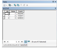

Figure 2: file 1 image overlaid on file2- with its attribute table
This figure 2 shows the over lay of file1 image with same value on file 2 image with value ranging between 1 to 3. So, these values are either 1, 2 or 3.
I want to know the count of value 1, 2 and 3 (from file 2 image) for each of the OID of file1 image. So I thought if we can combine these two file I will be able to achieve it. I hope I am clear in explaining this.
- Mark as New
- Bookmark
- Subscribe
- Mute
- Subscribe to RSS Feed
- Permalink
- Report Inappropriate Content
Well you were using the right word... it is the combine tool Combine—Help | ArcGIS for Desktop
- Mark as New
- Bookmark
- Subscribe
- Mute
- Subscribe to RSS Feed
- Permalink
- Report Inappropriate Content