- Home
- :
- All Communities
- :
- Products
- :
- ArcGIS for AutoCAD
- :
- ArcGIS for AutoCAD Questions
- :
- Importing CAD dwg into Arcmap
- Subscribe to RSS Feed
- Mark Topic as New
- Mark Topic as Read
- Float this Topic for Current User
- Bookmark
- Subscribe
- Mute
- Printer Friendly Page
Importing CAD dwg into Arcmap
- Mark as New
- Bookmark
- Subscribe
- Mute
- Subscribe to RSS Feed
- Permalink
- Report Inappropriate Content
Hi,
I'm an intermediate GIS user, but have not yet had the chance to integrate CAD with ArcGIS. Today, I am trying to view a Cad drawing (dwg) format in ArcMap. When I bring the file into arcmap, I can't see anything. However, the dwg file looks fine when I open it in a dwg reader.
Here's what I've tried:
- Adding the CAD file like I would any other layer. It shows up in my table of contents, but I can't see the file in the dataframe at all. If I "zoom to layer," then it zooms way out to 1:40 000 000 scale and I still don't see anything.
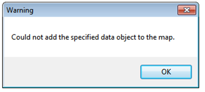
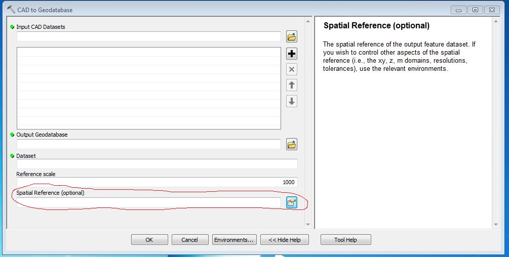
- Conversion from CAD to Geodatabase using that tool, and then adding a projection with the "project" tool. Both of these tools run successfully, but the resultant file gives the following error when I try to add it to the map:
I'm using version 10.1 of arcmap, and have a standard license. The cad file was made by an external consultant, so I don't know much about how it was made or what version of autocad was used. I've attached the file here. I do not have AutoCAD on my machine.
Anyone know what's going on here and/or how I can fix it?
Thanks!
- Mark as New
- Bookmark
- Subscribe
- Mute
- Subscribe to RSS Feed
- Permalink
- Report Inappropriate Content
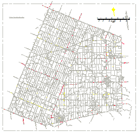
I can open it without a problem in ArcMap 10.3:
There is a point located at 0,0 which is will affect the zoom to layer to zoom out to a large extent.
The other important aspect to take into account, is the spatial reference the data frame has when you add the DWG. If it is geographic (lat, long) the planar coordinates will be interpreted as decimal degrees and make no sense at all.
Start a new session of ArcMap, don't define a spatial reference, add the DWG and zoom to X=522300 and Y=4821500.
- Mark as New
- Bookmark
- Subscribe
- Mute
- Subscribe to RSS Feed
- Permalink
- Report Inappropriate Content
The file loads for me, too (10.2.2).
I'm confused by this: "Conversion from CAD to Geodatabase using that tool, and then adding a projection with the "project" tool. "
The CAD file comes in an unknown CRS. You do have the option to define a CRS in the CAD to Geodatabase tool, however you don't mention using it. So, the output feature class in the geodatabase should still be unknown. The project tool should (correctly) not allow you to run it, since the CRS in the input feature class is unknown. Did you mean "Define Projection" tool, rather than "Project", or have you defined the CAD CRS at some other point?
The take home point: you need to know and define the CRS somewhere along the line.
- Mark as New
- Bookmark
- Subscribe
- Mute
- Subscribe to RSS Feed
- Permalink
- Report Inappropriate Content
One way to resolve this is when the "CAD to Geodatabase (Conversion)" tool is run. There is a provided option to choose a spatial reference.
As both Darren Wiens and Xander Bakker pointed out, you will need to know what coordinate reference system the CAD file should be in. Given that the visible drawing elements are not at X,Y close to 0,0, it looks like a coordinate reference system was probably used. Note that it is common for AutoCAD dwg files to be created without using a common coordinate reference system, in which case typically the drawn elements begin at or near an X,Y of 0,0 (the lower-left corner. These cases can be difficult to work with, as they are essentially in a "local" system).
So the challenge now is to figure out what the coordinate reference system (crs) that was used. I'd contact the source of the dwg file. Be aware that CAD folks don't use CRS like we do in GIS, so you may have to do some explaining/educating so they realize what you are after.
Chris Donohue, GISP
- Mark as New
- Bookmark
- Subscribe
- Mute
- Subscribe to RSS Feed
- Permalink
- Report Inappropriate Content
I'm a little late to the game here, but I thought I'd add my 2 cents. I went from one organization to another, and therefore from 10.2 to 10.1. I discovered in 10.1 that you have to use "Transformations" in the layer's properties. I use the following settings and it works just fine (be sure to check the "Enable Transformations" box):

- Mark as New
- Bookmark
- Subscribe
- Mute
- Subscribe to RSS Feed
- Permalink
- Report Inappropriate Content
I use this now in my ArcGIS 10.4 and it's great for placement of the CAD. The one difficulty I find is that out of the 385 CAD layers, I had only kept 3 On and not Freeze but all 385 layers come into Arc. What can I do to stop that? Delete the 382 layers? Is there another setting to have it convert only the On layers?