- Home
- :
- All Communities
- :
- User Groups
- :
- Coordinate Reference Systems
- :
- Questions
- :
- Working with vertical coordinate systems
- Subscribe to RSS Feed
- Mark Topic as New
- Mark Topic as Read
- Float this Topic for Current User
- Bookmark
- Subscribe
- Mute
- Printer Friendly Page
Working with vertical coordinate systems
- Mark as New
- Bookmark
- Subscribe
- Mute
- Subscribe to RSS Feed
- Permalink
- Report Inappropriate Content
I'm looking for a way to perform a height (z value) transformation from one vertical datum to another one. Both vertical datums exist in ArcGIS list. If I define a horizontal coordinate system, then I have a tool to project the data to another horizontal coordinate system, and set the correct datum transformation.
I don't see a place to do the same between 2 vertical coordinate systems. Does this funcionality exist in ArcGIS Desktop 10.3.1?
Alternatively, can I do it using ArcObjects?
Thanks,
Yigal
- Mark as New
- Bookmark
- Subscribe
- Mute
- Subscribe to RSS Feed
- Permalink
- Report Inappropriate Content
In this thread ... Melita Kennedy gives an emphatics NORe: Datum transformations
I quote
Yes, as of today (October 13, 2015) and ArcGIS 10.3.x, we do not support transformation of vertical coordinate systems, including between ellipsoidal heights and elevations/geoidal heights.
- Mark as New
- Bookmark
- Subscribe
- Mute
- Subscribe to RSS Feed
- Permalink
- Report Inappropriate Content
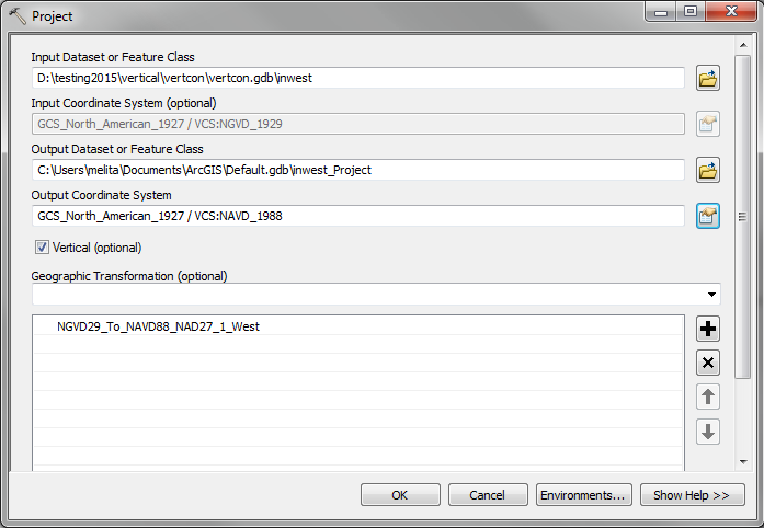
However, now that 10.4.0 is with the release team (AKA no more development changes), there are some vertical transformations possible in ArcGIS for Desktop 10.4.0. It's currently for vector data only.
The Project tool has a check box to enable vertical transformations. The input data must have vertical data and a vertical coordinate system defined. When you set the output coordinate systems, you can now set both the horizontal (geographic/projected) and vertical coordinate systems.
We look up a combination horizontal and vertical transformation using a table, hvtdefaults.json, which is in the pedata folder of the install. It's known to be incomplete. If it comes up with transformations that you don't agree with, you can either edit the json file or try to perform the projection/transformation in multiple steps.
Vertical transformation data tends to be in grid files which are large. For 10.4.0, there's now a separate ArcGIS Coordinate Systems Data setup which can optionally install the US geoid2012 files and VERTCON files (NGVD29 / NAVD88), and the world EGM84 and EGM2008 1'x1' or 2.5'x2.5' geoid models.
There's some supporting functionality in ArcObjects too.
Here's a picture:
Melita
- Mark as New
- Bookmark
- Subscribe
- Mute
- Subscribe to RSS Feed
- Permalink
- Report Inappropriate Content
Melita Kennedy would love to see an example of the effect of changes in coordinates using with and without the vertical correction. maybe Latitude 45.0, Longitude -75.0 in whatever is preferred. I don't have 10.4 installed, but I am writing and would like to see what is coming before I finish
- Mark as New
- Bookmark
- Subscribe
- Mute
- Subscribe to RSS Feed
- Permalink
- Report Inappropriate Content
Er, what? If you performed an equation-based transformation (3 or 7 parameter) and had ellipsoidal heights for the input data, then you would see small differences in the lat/lon values depending on whether you converted the ellipsoidal heights to the output gcs's ellipsoid. Otherwise, it would just be whatever the horizontal transformation does.
- Mark as New
- Bookmark
- Subscribe
- Mute
- Subscribe to RSS Feed
- Permalink
- Report Inappropriate Content
that is what I am looking for... the results of incorporating the vertical as in your first sentence. I get the horizontal transform
- Mark as New
- Bookmark
- Subscribe
- Mute
- Subscribe to RSS Feed
- Permalink
- Report Inappropriate Content
Make sure the input data has an ellipsoid-based VCS defined, Check on the vertical option. Make sure the output VCS is also ellipsoidal.
- Mark as New
- Bookmark
- Subscribe
- Mute
- Subscribe to RSS Feed
- Permalink
- Report Inappropriate Content
Has anyone found out if within 10.5.1 it's possible to transform a raster from NGVD29 to NAVD88?
- Mark as New
- Bookmark
- Subscribe
- Mute
- Subscribe to RSS Feed
- Permalink
- Report Inappropriate Content
No, that functionality is in 10.6 though
- Mark as New
- Bookmark
- Subscribe
- Mute
- Subscribe to RSS Feed
- Permalink
- Report Inappropriate Content
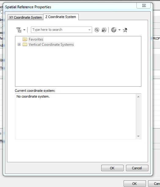
Hi, I have a 3D point file that I'm trying to convert from NAVD 88 to NGVD 29 but in the project tool box the "Z coordinate system" tab appears grayed out (see image). Am I missing something here, a file or doing something incorrectly? 'm running 10.5.1 but tried it in 10.6 and the same thing happens.