- Home
- :
- All Communities
- :
- Products
- :
- ArcGIS Survey123
- :
- ArcGIS Survey123 Questions
- :
- Error connecting to Portal
- Subscribe to RSS Feed
- Mark Topic as New
- Mark Topic as Read
- Float this Topic for Current User
- Bookmark
- Subscribe
- Mute
- Printer Friendly Page
Error connecting to Portal
- Mark as New
- Bookmark
- Subscribe
- Mute
- Subscribe to RSS Feed
- Permalink
- Report Inappropriate Content
I keep getting an error when I try to connect to my portal site. I am pretty sure I meet the requirement specified by the error but still no dice.
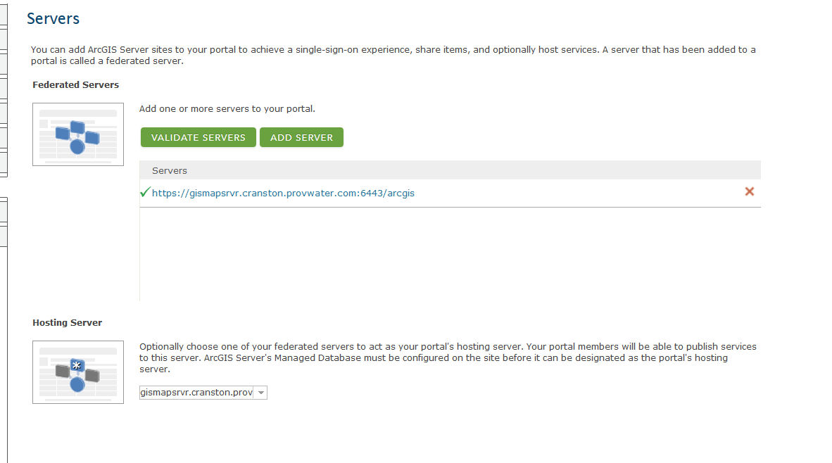
As you can see I have a hosting server:
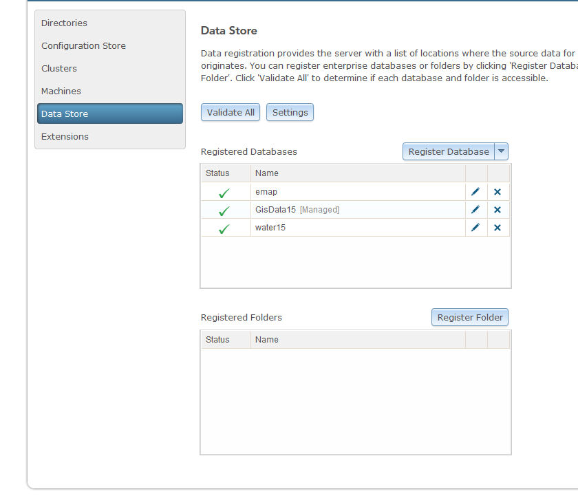
I also have a datastore:
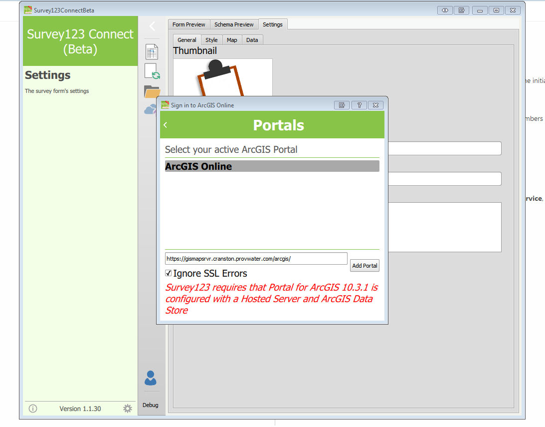
But I still get this error when trying to connect:
Thank in advance for any help.
Ray
- Mark as New
- Bookmark
- Subscribe
- Mute
- Subscribe to RSS Feed
- Permalink
- Report Inappropriate Content
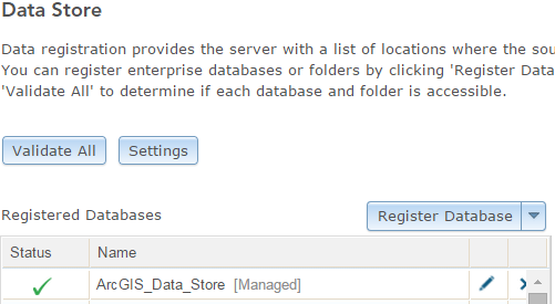
I have the same issue and do have an ArcGIS Data Store present.
I also have a similar thread on he github site.
This is with Survey123Connect v1.2.18 and Portal 10.3.1
Happy to retry when 10.4 is released.
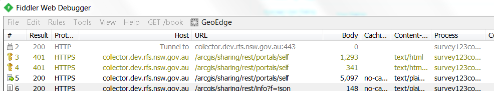
Possibly authentication related as my Portal is setup for IWA, however I can see data coming back via fiddler.
{
"access": "private",
"allSSL": true,
"availableCredits": 0,
"basemapGalleryGroupQuery": "id:5dcb27c3d6964a1ca624f90fb066251b",
"canListApps": true,
"canListData": true,
"canListPreProvisionedItems": true,
"canProvisionDirectPurchase": true,
"canSearchPublic": true,
"canShareBingPublic": false,
"canSharePublic": true,
"canSignInArcGIS": true,
"canSignInIDP": true,
"colorSetsGroupQuery": "title:\"Esri Colors\" AND owner:esri_en",
"commentsEnabled": false,
"created": 1358967600000,
"culture": "en",
"customBaseUrl": "portal",
"databaseQuota": 0,
"databaseUsage": 0,
"defaultBasemap": {
"id": "9d98f7113f9b469c8c302b210db7b922",
"title": "Topographic",
"baseMapLayers": [{
"id": "defaultBasemap",
"opacity": 1,
"visibility": true,
"url": "http://services.arcgisonline.com/ArcGIS/rest/services/World_Topo_Map/MapServer",
"resourceInfo": {
"currentVersion": 10.3,
"serviceDescription": "This map is designed to be used as a basemap by GIS professionals and as a reference map by anyone. The map includes administrative boundaries, cities, water features, physiographic features, parks, landmarks, highways, roads, railways, and airports overlaid on land cover and shaded relief imagery for added context. The map provides coverage for the world down to a scale of ~1:72k. Coverage is provided down to ~1:4k for the following areas: Australia and New Zealand; India; Europe; Canada; Mexico; the continental United States and Hawaii; South America and Central America; Africa; and most of the Middle East. Coverage down to ~1:1k and ~1:2k is available in select urban areas. This basemap was compiled from a variety of best available sources from several data providers, including the U.S. Geological Survey (USGS), U.S. Environmental Protection Agency (EPA), U.S. National Park Service (NPS), Food and Agriculture Organization of the United Nations (FAO), Department of Natural Resources Canada (NRCAN), GeoBase, Agriculture and Agri-Food Canada, DeLorme, HERE, Esri, OpenStreetMap contributors, and the GIS User Community. For more information on this map, including the terms of use, visit us <a href=\"http://goto.arcgisonline.com/maps/World_Topo_Map \" target=\"_new\" >online</a>.",
"mapName": "Layers",
"description": "This map is designed to be used as a basemap by GIS professionals and as a reference map by anyone. The map includes administrative boundaries, cities, water features, physiographic features, parks, landmarks, highways, roads, railways, and airports overlaid on land cover and shaded relief imagery for added context. The map provides coverage for the world down to a scale of ~1:72k. Coverage is provided down to ~1:4k for the following areas: Australia and New Zealand; India; Europe; Canada; Mexico; the continental United States and Hawaii; South America and Central America; Africa; and most of the Middle East. Coverage down to ~1:1k and ~1:2k is available in select urban areas. This basemap was compiled from a variety of best available sources from several data providers, including the U.S. Geological Survey (USGS), U.S. Environmental Protection Agency (EPA), U.S. National Park Service (NPS), Food and Agriculture Organization of the United Nations (FAO), Department of Natural Resources Canada (NRCAN), GeoBase, Agriculture and Agri-Food Canada, DeLorme, HERE, Esri, OpenStreetMap contributors, and the GIS User Community. For more information on this map, including our terms of use, visit us online at http://goto.arcgisonline.com/maps/World_Topo_Map",
"copyrightText": "Sources: Esri, HERE, DeLorme, Intermap, increment P Corp., GEBCO, USGS, FAO, NPS, NRCAN, GeoBase, IGN, Kadaster NL, Ordnance Survey, Esri Japan, METI, Esri China (Hong Kong), swisstopo, MapmyIndia, © OpenStreetMap contributors, and the GIS User Community",
"supportsDynamicLayers": false,
"layers": [{
"id": 0,
"name": "Citations",
"parentLayerId": -1,
"defaultVisibility": false,
"subLayerIds": null,
"minScale": 0,
"maxScale": 0
}],
"tables": [],
"spatialReference": {
"wkid": 102100,
"latestWkid": 3857
},
"singleFusedMapCache": true,
"tileInfo": {
"rows": 256,
"cols": 256,
"dpi": 96,
"format": "JPEG",
"compressionQuality": 90,
"origin": {
"x": -2.0037508342787E7,
"y": 2.0037508342787E7
},
"spatialReference": {
"wkid": 102100,
"latestWkid": 3857
},
"lods": [
{
"level": 0,
"resolution": 156543.03392800014,
"scale": 5.91657527591555E8
},
{
"level": 1,
"resolution": 78271.51696399994,
"scale": 2.95828763795777E8
},
{
"level": 2,
"resolution": 39135.75848200009,
"scale": 1.47914381897889E8
},
{
"level": 3,
"resolution": 19567.87924099992,
"scale": 7.3957190948944E7
},
{
"level": 4,
"resolution": 9783.93962049996,
"scale": 3.6978595474472E7
},
{
"level": 5,
"resolution": 4891.96981024998,
"scale": 1.8489297737236E7
},
{
"level": 6,
"resolution": 2445.98490512499,
"scale": 9244648.868618
},
{
"level": 7,
"resolution": 1222.992452562495,
"scale": 4622324.434309
},
{
"level": 8,
"resolution": 611.4962262813797,
"scale": 2311162.217155
},
{
"level": 9,
"resolution": 305.74811314055756,
"scale": 1155581.108577
},
{
"level": 10,
"resolution": 152.87405657041106,
"scale": 577790.554289
},
{
"level": 11,
"resolution": 76.43702828507324,
"scale": 288895.277144
},
{
"level": 12,
"resolution": 38.21851414253662,
"scale": 144447.638572
},
{
"level": 13,
"resolution": 19.10925707126831,
"scale": 72223.819286
},
{
"level": 14,
"resolution": 9.554628535634155,
"scale": 36111.909643
},
{
"level": 15,
"resolution": 4.77731426794937,
"scale": 18055.954822
},
{
"level": 16,
"resolution": 2.388657133974685,
"scale": 9027.977411
},
{
"level": 17,
"resolution": 1.1943285668550503,
"scale": 4513.988705
},
{
"level": 18,
"resolution": 0.5971642835598172,
"scale": 2256.994353
},
{
"level": 19,
"resolution": 0.29858214164761665,
"scale": 1128.497176
},
{
"level": 20,
"resolution": 0.14929107082380833,
"scale": 564.248588
},
{
"level": 21,
"resolution": 0.07464553541190416,
"scale": 282.124294
},
{
"level": 22,
"resolution": 0.03732276770595208,
"scale": 141.062147
},
{
"level": 23,
"resolution": 0.01866138385297604,
"scale": 70.5310735
}
]
},
"initialExtent": {
"xmin": -2.8848255049479112E7,
"ymin": -2077452.082122866,
"xmax": 2.8848255049479112E7,
"ymax": 1.6430757376790084E7,
"spatialReference": {
"wkid": 102100,
"latestWkid": 3857
}
},
"fullExtent": {
"xmin": -2.0037507067161843E7,
"ymin": -1.9971868880408604E7,
"xmax": 2.0037507067161843E7,
"ymax": 1.997186888040863E7,
"spatialReference": {
"wkid": 102100,
"latestWkid": 3857
}
},
"minScale": 5.91657527591555E8,
"maxScale": 70.5310735,
"units": "esriMeters",
"supportedImageFormatTypes": "PNG32,PNG24,PNG,JPG,DIB,TIFF,EMF,PS,PDF,GIF,SVG,SVGZ,BMP",
"documentInfo": {
"Title": "World Topographic Map",
"Author": "Esri",
"Comments": "",
"Subject": "topographic, topography, administrative boundaries, cities, water features, physiographic features, parks, landmarks, highways, roads, railways, airports, land cover, shaded relief imagery",
"Category": "imageryBaseMapsEarthCover (Imagery, basemaps, and land cover)",
"AntialiasingMode": "None",
"TextAntialiasingMode": "Force",
"Keywords": "World,Global,Europe,North America,South America,Southern Africa,Australia,New Zealand,India"
},
"capabilities": "Map,Tilemap,Query,Data",
"supportedQueryFormats": "JSON, AMF",
"exportTilesAllowed": false,
"maxRecordCount": 100,
"maxImageHeight": 4096,
"maxImageWidth": 4096,
"supportedExtensions": "KmlServer"
}
}],
"operationalLayers": []
},
"defaultExtent": {
"type": "extent",
"xmin": -1.800000000808016E7,
"ymin": -1.1999999975017535E7,
"xmax": 1.800000001482417E7,
"ymax": 1.6000000047989592E7,
"spatialReference": {"wkid": 102100}
},
"description": "<br/>",
"featuredGroups": [{
"owner": "admin",
"title": "Featured Maps and Apps"
}],
"featuredGroupsId": "",
"featuredItemsGroupQuery": "",
"galleryTemplatesGroupQuery": "title:\"Gallery Templates\" AND owner:esri_en",
"helpBase": "/arcgis/portalhelp/en/website/help/",
"helpMap": {
"v": "1.0",
"m": {
"120000464": "0193/019300000048000000.htm",
"120000474": "0193/01930000003m000000.htm",
"120000467": "0193/01930000003m000000.htm#FILE",
"120000470": "0193/01930000004q000000.htm",
"120000468": "0193/019300000018000000.htm",
"120000999": "0193/0193000000w4000000.htm",
"120000943": "0193/0193000000p0000000.htm",
"120000944": "0193/0193000000r1000000.htm",
"120000945": "0193/0193000000rs000000.htm",
"120000946": "0193/0193000000t0000000.htm",
"120000963": "0193/0193000000nn000000.htm",
"120000947": "0193/0193000000qw000000.htm",
"120000948": "0193/0193000000r3000000.htm",
"120000949": "0193/0193000000q5000000.htm",
"120000950": "0193/0193000000p3000000.htm",
"120000951": "0193/0193000000n7000000.htm",
"120000952": "0193/0193000000pm000000.htm",
"120000953": "0193/0193000000n8000000.htm",
"120000954": "0193/0193000000n4000000.htm",
"120000955": "0193/0193000000nz000000.htm",
"120000956": "0193/0193000000r6000000.htm",
"120000957": "0193/0193000000qt000000.htm",
"120000958": "0193/0193000000nr000000.htm",
"120000959": "0193/0193000000nv000000.htm",
"120000960": "0193/0193000000pq000000.htm",
"120000961": "0193/0193000000q6000000.htm",
"120000964": "0193/0193000000tn000000.htm",
"120001020": "0193/0193000000w6000000.htm",
"120001021": "0193/0193000000w5000000.htm",
"120000473": "0193/01930000003t000000.htm",
"120000456": "0193/01930000000w000000.htm",
"120000969": "0193/019300000032000000.htm#REG_APP",
"120000455": "0193/019300000002000000.htm",
"120000902": "0193/01930000009t000000.htm",
"120000814": "0193/01930000000n000000.htm",
"120000516": "0193/019300000022000000.htm#WEB_STORAGE",
"120000966": "0193/0193000000tp000000.htm",
"120000454": "0193/01930000000p000000.htm",
"120000597": "0193/01930000004v000000.htm",
"120000471": "0193/01930000002q000000.htm",
"120000469": "0193/019300000095000000.htm",
"120000465": "0193/01930000000t000000.htm",
"120000476": "0193/01930000001q000000.htm",
"120000463": "0193/01930000001r000000.htm",
"120001018": "0193/0193000000ts000000.htm",
"120000815": "0193/019300000098000000.htm",
"120000816": "0193/019300000099000000.htm",
"120000817": "0193/01930000009m000000.htm"
}
},
"helperServices": {
"defaultElevationLayers": [{
"url": "https://elevation3ddev.arcgis.com/arcgis/rest/services/WorldElevation3D/Terrain3D/ImageServer",
"id": "globalElevation",
"layerType": "ArcGISTiledElevationServiceLayer"
}],
"geocode": [{
"url": "https://geocode.arcgis.com/arcgis/rest/services/World/GeocodeServer",
"northLat": "Ymax",
"southLat": "Ymin",
"eastLon": "Xmax",
"westLon": "Xmin",
"name": "Esri World Geocoder",
"suggest": true
}],
"geometry": {"url": "https://collector.dev.rfs.nsw.gov.au/arcgisserver/rest/services/Utilities/Geometry/GeometryServer"},
"printTask": {"url": "https://collector.dev.rfs.nsw.gov.au/arcgisserver/rest/services/Utilities/PrintingTools/GPServer/Exp..."}
},
"homePageFeaturedContent": "",
"homePageFeaturedContentCount": 12,
"id": "0123456789ABCDEF",
"isPortal": true,
"layerTemplatesGroupQuery": "title:\"Esri Layer Templates\" AND owner:esri_en",
"maxTokenExpirationMinutes": -1,
"modified": 1358967600000,
"name": "DEV NSW RFS Portal for ArcGIS",
"portalMode": "singletenant",
"portalName": "Portal for ArcGIS",
"portalProperties": {"links": {"contactUs": {
"url": "mailto:gis@rfs.nsw.gov.au?subject=PortalHelp",
"visible": true
}}},
"rotatorPanels": [{
"id": "banner-2",
"innerHTML": "<img src='images/banner-2.jpg' style='-webkit-border-radius:0 0 10px 10px; -moz-border-radius:0 0 10px 10px; -o-border-radius:0 0 10px 10px; border-radius:0 0 10px 10px; margin-top:0; width:960px; height:180px;'/><div style='position:absolute; bottom:80px; left:80px; max-height:65px; width:660px; margin:0;'><span style='position:absolute; bottom:0; margin-bottom:0; line-height:normal; font-family:HelveticaNeue,Verdana; font-weight:600; font-size:32px; color:#369;'>DEV NSW RFS Portal for ArcGIS<\/span><\/div>"
}],
"showHomePageDescription": false,
"staticImagesUrl": "/arcgis/portalimages",
"storageQuota": 107374182400,
"storageUsage": 121464,
"stylesGroupQuery": "title:\"Esri Styles\" AND owner:esri_en",
"supportsHostedServices": true,
"symbolSetsGroupQuery": "title:\"Esri Symbols\" AND owner:esri_en",
"templatesGroupQuery": "title:\"Web Application Templates\" AND owner:esri_en",
"thumbnail": null,
"units": "metric",
"useStandardizedQuery": true,
"hostedServerHostedFolder": "Hosted",
"httpPort": 80,
"httpsPort": 443,
"portalLocalHostname": "SVDEV-PRES15.RFS.NSW.GOV.AU",
"portalLocalHttpPort": 7080,
"portalLocalHttpsPort": 7443,
"portalHostname": "collector.dev.rfs.nsw.gov.au/arcgis",
"supportsOAuth": true,
"samlEnabled": false,
"disableSignup": false,
"isWindows": true,
"platform": "Windows Server 2012 R2",
"mfaEnabled": false,
"mfaAdmins": [],
"user": {
"username": "XXX@WILDFIRE",
"fullName": "XXX",
"preferredView": "GIS",
"description": null,
"email": "",
"userType": "arcgisonly",
"idpUsername": "WILDFIRE\\XXX",
"favGroupId": "a45cf829564d46c19a97eaf3b53b7874",
"lastLogin": 1455598507982,
"mfaEnabled": false,
"validateUserProfile": true,
"access": "public",
"storageUsage": 121464,
"storageQuota": 107374182400,
"orgId": "0123456789ABCDEF",
"role": "org_admin",
"privileges": [
"features:user:edit",
"features:user:fullEdit",
"marketplace:admin:manage",
"marketplace:admin:purchase",
"marketplace:admin:startTrial",
"opendata:user:designateGroup",
"opendata:user:openDataAdmin",
"portal:admin:assignToGroups",
"portal:admin:changeUserRoles",
"portal:admin:deleteGroups",
"portal:admin:deleteItems",
"portal:admin:deleteUsers",
"portal:admin:disableUsers",
"portal:admin:inviteUsers",
"portal:admin:manageEnterpriseGroups",
"portal:admin:manageLicenses",
"portal:admin:reassignGroups",
"portal:admin:reassignItems",
"portal:admin:reassignUsers",
"portal:admin:updateGroups",
"portal:admin:updateItems",
"portal:admin:updateUsers",
"portal:admin:viewGroups",
"portal:admin:viewItems",
"portal:admin:viewUsers",
"portal:publisher:publishFeatures",
"portal:publisher:publishScenes",
"portal:publisher:publishTiles",
"portal:user:createGroup",
"portal:user:createItem",
"portal:user:joinGroup",
"portal:user:joinNonOrgGroup",
"portal:user:shareGroupToOrg",
"portal:user:shareGroupToPublic",
"portal:user:shareToGroup",
"portal:user:shareToOrg",
"portal:user:shareToPublic",
"premium:user:demographics",
"premium:user:elevation",
"premium:user:geocode",
"premium:user:geoenrichment",
"premium:user:networkanalysis",
"premium:user:spatialanalysis"
],
"disabled": false,
"tags": [],
"culture": "en",
"region": "WO",
"units": "english",
"thumbnail": null,
"created": 1418597742165,
"modified": 1455598507952,
"provider": "enterprise"
}
}
- Mark as New
- Bookmark
- Subscribe
- Mute
- Subscribe to RSS Feed
- Permalink
- Report Inappropriate Content
Hi,
I updated the Survey123 and ArcGIS for Server Blog Post with additional information. May the crux of the problem is that you are using Integrated Windows Authentication. You can configure your Portal with Windows Active Directory users, but the authentication must be OAuth for Survey123 for ArcGIS to work.
Ismael