- Home
- :
- All Communities
- :
- Developers
- :
- JavaScript Maps SDK
- :
- JavaScript Maps SDK Questions
- :
- Get values after query
- Subscribe to RSS Feed
- Mark Topic as New
- Mark Topic as Read
- Float this Topic for Current User
- Bookmark
- Subscribe
- Mute
- Printer Friendly Page
Get values after query
- Mark as New
- Bookmark
- Subscribe
- Mute
- Subscribe to RSS Feed
- Permalink
- Report Inappropriate Content
Hi Users,
I am using an existing example to perform a query when I am drawing a polygon and it will give me the count of all the features inside it.
Mentioned below is the code.
function initSelectToolbar (event) {
selectionToolbar = new Draw(event.map);
var selectQuery = new Query();
on(selectionToolbar, "DrawEnd", function (geometry) {
selectionToolbar.deactivate();
selectQuery.geometry = geometry;
DREAM_2D .selectFeatures(selectQuery,
FeatureLayer.SELECTION_NEW);
});
}
function sumGasProduction (event) {
var countOfFeatures = 0;
arrayUtil.forEach(event.features, function (feature) {
countOfFeatures++;
});
dom.byId('messages').innerHTML = "<b>Number of points selected: " +
countOfFeatures + " wells. </b>";
}
But after getting the count I need to get the details of each and every point which got selected during the query.
Can someone please help me to resolve it.
Thanks
- Mark as New
- Bookmark
- Subscribe
- Mute
- Subscribe to RSS Feed
- Permalink
- Report Inappropriate Content
You have each feature getting returned in the arrayUtil.forEach, you just need more code in that loop to take advantage of them. What do you want to do with them, populate a list or grid?
- Mark as New
- Bookmark
- Subscribe
- Mute
- Subscribe to RSS Feed
- Permalink
- Report Inappropriate Content
Aditya,
Here's a visual representation of this:

Some info on the attributes from the selection:
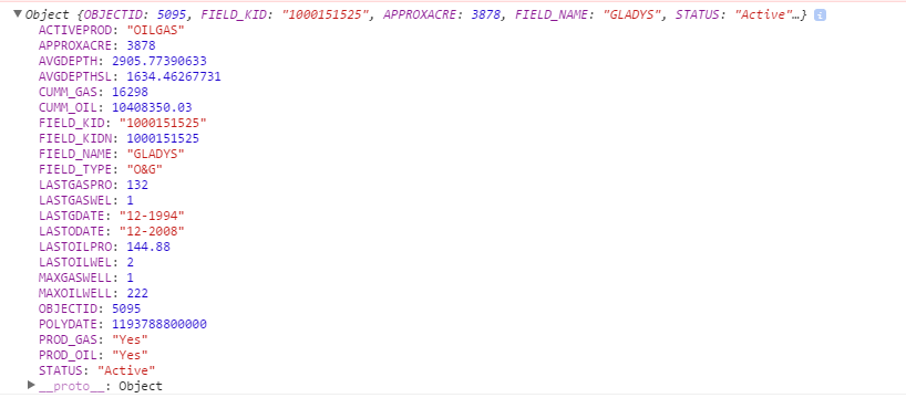
Is this the kind of info you need?
- Mark as New
- Bookmark
- Subscribe
- Mute
- Subscribe to RSS Feed
- Permalink
- Report Inappropriate Content
Thanks..
- Mark as New
- Bookmark
- Subscribe
- Mute
- Subscribe to RSS Feed
- Permalink
- Report Inappropriate Content
Thanks for the reply.I want to take the data and transfer the data in one .net application through ajax.
- Mark as New
- Bookmark
- Subscribe
- Mute
- Subscribe to RSS Feed
- Permalink
- Report Inappropriate Content
FYI, you can also just hit the service directly, outside of your mapping app, if that's ever useful to you:
"xmin" : -10857096.337411141, "ymin" : 4514682.962763, "xmax" : -10852204.367600897, "ymax" : 4510020.30403761,
"spatialReference" : {"wkid" : 102100}
}
&geometryType=esriGeometryEnvelope&inSR=102100&spatialRel=esriSpatialRelContains&relationParam=&objectIds=&where=&time=&returnIdsOnly=false&returnGeometry=true&maxAllowableOffset=&outSR=&outFields=ACTIVEPROD,APPROXACRE,AVGDEPTH,FIELD_NAME,FIELD_TYPE,PROD_GAS,PROD_OIL,STATUS&f=json
Copy this and paste in browser, you'll get a response back, e.g.:
{"displayFieldName":"FIELD_NAME","fieldAliases":{"ACTIVEPROD":"Active Production","APPROXACRE":"Approximate Acre","AVGDEPTH":"Average Depth","FIELD_NAME":"Field Name","FIELD_TYPE":"Field Type","PROD_GAS":"Production Gas","PROD_OIL":"Production Oil","STATUS":"Status"},"geometryType":"esriGeometryPolygon","spatialReference":{"wkid":4267},"fields":[{"name":"ACTIVEPROD","type":"esriFieldTypeString","alias":"Active Production","length":10},{"name":"APPROXACRE","type":"esriFieldTypeDouble","alias":"Approximate Acre"},{"name":"AVGDEPTH","type":"esriFieldTypeDouble","alias":"Average Depth"},{"name":"FIELD_NAME","type":"esriFieldTypeString","alias":"Field Name","length":150},{"name":"FIELD_TYPE","type":"esriFieldTypeString","alias":"Field Type","length":5},{"name":"PROD_GAS","type":"esriFieldTypeString","alias":"Production Gas","length":3},{"name":"PROD_OIL","type":"esriFieldTypeString","alias":"Production Oil","length":3},{"name":"STATUS","type":"esriFieldTypeString","alias":"Status","length":50}],"features":[{"attributes":{"ACTIVEPROD":"GAS","APPROXACRE":158,"AVGDEPTH":0,"FIELD_NAME":"CLEARWATER NORTHEAST","FIELD_TYPE":"GAS","PROD_GAS":"Yes","PROD_OIL":"No","STATUS":"Active"},"geometry":{"rings":[[[-97.511999713999955,37.518708764000053],[-97.51425102099995,37.51864921400005],[-97.514269636999984,37.520450063000055],[-97.514288417999978,37.522267735000071],[-97.514289758999951,37.52239806800003],[-97.514307389999942,37.524102785000025],[-97.514326532999974,37.525954743000057],[-97.512054895999938,37.525979914000061],[-97.509767392999947,37.526005203000068],[-97.507485631999941,37.526030415000037],[-97.505202250999957,37.526055596000049],[-97.50520000299997,37.52424086700006],[-97.505197783999961,37.52244902700005],[-97.505195574999959,37.520663002000049],[-97.505193388999942,37.518888600000025],[-97.505300545999944,37.518885769000065],[-97.50747073499997,37.518828447000033],[-97.509739700999944,37.518768474000069],[-97.509800642999949,37.518766893000077],[-97.511999713999955,37.518708764000053]]]}}]}
In the above, I asked for it to filter on an envelope (map extent) for fields contained by said extent. I asked for the service to give me the geometry rings as well as several field values. You can make the requests right through AJAX, or as an http response in .NET. Of course, you'd need the extent ahead of time! But, you can send in any geometry object - polygons, polylines, points, etc, and set your spatial relation in the request URL. You can also send queries as well, say by attribute, for instance.
- Mark as New
- Bookmark
- Subscribe
- Mute
- Subscribe to RSS Feed
- Permalink
- Report Inappropriate Content
Each feature has attributes and if you create a JSON formatted object you should be able to pass it to .NET.
I don't think you need countOfFeatures++. The number of features returned is available without it.
Typically when you have a function that's the result handler of a query, it's more common to call the output results, not event.
function sumGasProduction (results) {
var countOfFeatures = results.features.length;
myData = arrayUtil.map(results.features, function(feature){
return {
'id': feature.attributes.OBJECTID,
'ActiveProduct':feature.attributes.ACTIVEPROD,
'Average_Depth':feature.attributes.AVGDEPTH,
'Status':feature.attributes.STATUS
};
});
dom.byId('messages').innerHTML = "<b>Number of points selected: " +
countOfFeatures + " wells. </b>";
}
}
Then myData could be passed to the .NET application.
- Mark as New
- Bookmark
- Subscribe
- Mute
- Subscribe to RSS Feed
- Permalink
- Report Inappropriate Content
Thanks a lot Tracy, it really helped.