- Home
- :
- All Communities
- :
- Industries
- :
- State & Local Government
- :
- State & Local Government Questions
- :
- Creating a wind zone polygons from a table
- Subscribe to RSS Feed
- Mark Topic as New
- Mark Topic as Read
- Float this Topic for Current User
- Bookmark
- Subscribe
- Mute
- Printer Friendly Page
- Mark as New
- Bookmark
- Subscribe
- Mute
- Subscribe to RSS Feed
- Permalink
- Report Inappropriate Content
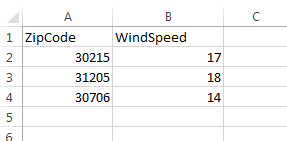
I have an excel spreadsheet showing different wind speeds for a location based off of zip codes. I want to try to create polygons to represent each windspeed for each location. How can this be done in ArcMap? The table only includes Zip Codes and Windspeed
Solved! Go to Solution.
Accepted Solutions
- Mark as New
- Bookmark
- Subscribe
- Mute
- Subscribe to RSS Feed
- Permalink
- Report Inappropriate Content
You shouldn't have to create a polygon layer.
There are zipcode boundary files already created by the CENSUS bureau. If you do not already have a layer, what did you join the 'windspeed' attribute table to?
What you need to do is symbolize each zip code by wind speed.
Layer Properties--> Symbology --> Categories --> choose the 'WindSpeed' field
- Mark as New
- Bookmark
- Subscribe
- Mute
- Subscribe to RSS Feed
- Permalink
- Report Inappropriate Content
If that's the only data your table contains, you'll need to get a polygon layer of zipcode boundaries--> Join that to your wind table --> symbolize by category (or label features by wind speed)
2014 TIGER/Line® Shapefiles --> Select 'Zip Code' from the drop down box
- Mark as New
- Bookmark
- Subscribe
- Mute
- Subscribe to RSS Feed
- Permalink
- Report Inappropriate Content
I Tried this but all I get is null values for the zipcode feature. The Zip Codes and wind speeds were given to me in a .pdf format. I then copied the values to an Excel spreadsheet. Then I opened Access and imported the spreadsheet, then exported it to a .dbf file to bring into ArcMap. I then did a Join with my Zip Code feature class but all the values for zip code become 'null'. Is there anyway to solve this?
- Mark as New
- Bookmark
- Subscribe
- Mute
- Subscribe to RSS Feed
- Permalink
- Report Inappropriate Content
What I would do it this:
1.) Copy and paste zip code/ windspeed data into new Excel sheet
2.) Add zip code polygon layer to ArcMap
3.) Add newly created windspeed .xls table into arcmap
4.) Join .xls table to polygon layer by Zipcode field
5.) Export layer as .shp to solidify joined features
Let me know if that works. Arc is sometimes finicky when working with tables. So start with a fresh .xls table.
- Mark as New
- Bookmark
- Subscribe
- Mute
- Subscribe to RSS Feed
- Permalink
- Report Inappropriate Content
Will have to try this. I've never tried joining an .xls file in ArcMap. I've always converted it to a .dbf file and then brought it into ArcMap to perform the join
- Mark as New
- Bookmark
- Subscribe
- Mute
- Subscribe to RSS Feed
- Permalink
- Report Inappropriate Content
Also compare the two zipcode fields...one may be aligned left (representing text data) and the other right (representing numeric data). If they are not the same data type you will have to convert one of them so that the data types match.
- Mark as New
- Bookmark
- Subscribe
- Mute
- Subscribe to RSS Feed
- Permalink
- Report Inappropriate Content
Scott,
As Mitch said, ArcGIS gets finicky sometimes with joins... If Dan's suggestion doesn't work for you still, you can try saving as a flat file (.txt, .csv). You can do this right from Excel, and then specify a schema.ini text file driver companion (ArcGIS should read this - just make sure it's in the same folder as your flat file):
https://msdn.microsoft.com/en-us/library/ms709353(v=vs.85).aspx
Inside of the ini, you can specify your flat file, datatypes, etc, e.g.
[Zips.txt]
Col1=ZipCode Text Width 5
Col2=WindSpeed Integer Width 2
You shouldn't have to do this, but it does allow you to get down to the basics and eliminate funkiness.
- Mark as New
- Bookmark
- Subscribe
- Mute
- Subscribe to RSS Feed
- Permalink
- Report Inappropriate Content
Tried making sure each table has the same data types but still no luck. My base zip code layer has the data type set to Text and length set to 10 so I imported my Excel table into Access and made sure that column was set to Text but I don't know where you can set the length. By default it sets it to 254. Can you set the length in the properties while the table is still in Access?
- Mark as New
- Bookmark
- Subscribe
- Mute
- Subscribe to RSS Feed
- Permalink
- Report Inappropriate Content
You should close Access if the program is running while making edits in ArcMap just for safe measure.
Could you please send me the .xls and .shp file please?
Use this if needed :
mitchh300@gmail.com
- Mark as New
- Bookmark
- Subscribe
- Mute
- Subscribe to RSS Feed
- Permalink
- Report Inappropriate Content
the field width doesnt matter, just the data type