- Home
- :
- All Communities
- :
- Products
- :
- Imagery and Remote Sensing
- :
- Imagery Questions
- :
- Removing stripes from Landsat 7 SLC OFF images
- Subscribe to RSS Feed
- Mark Topic as New
- Mark Topic as Read
- Float this Topic for Current User
- Bookmark
- Subscribe
- Mute
- Printer Friendly Page
Removing stripes from Landsat 7 SLC OFF images
- Mark as New
- Bookmark
- Subscribe
- Mute
- Subscribe to RSS Feed
- Permalink
- Report Inappropriate Content
I am currently trying to find a way of removing the stripes left from the SLC sensor malfunction on Landsat 7. Is there a realtively quick and simple way of filling the 'no data' stripes in ArcGIS?
I will be using the images for land classification on scenes taken between 2002 and 2013, so using images from other satellites is not an option.
I would appreciate any assitance!
Solved! Go to Solution.
Accepted Solutions
- Mark as New
- Bookmark
- Subscribe
- Mute
- Subscribe to RSS Feed
- Permalink
- Report Inappropriate Content
Hi Laura, the last link is still working
gapfil_AG9x_10x.rar — RGhost — file sharing
Check the 2 pdfs if you have problems with the tool.
Here
you can download the new landsat v8 data for free.. You need only to register an account
I uploaded the free idl version of the tool. It's a x86 application, but is still good
external link here
To start the tool, double click on frame_and_fill_win32.exe.
For more info read the read.txt file..
- Mark as New
- Bookmark
- Subscribe
- Mute
- Subscribe to RSS Feed
- Permalink
- Report Inappropriate Content
If you have access to the Spatial Analyst Extension, one possibility is to recalculate the No Data areas to a different value using CON:
Conditional Evaluation with Con
ArcGIS Help (10.2, 10.2.1, and 10.2.2)
Con (Spatial Analyst) tool
ArcGIS Help (10.2, 10.2.1, and 10.2.2)
One caveat - doing so will universally change all No Data areas, so check to see if there are areas where No Data will still be appropriate. If that is the situation, there will be other process steps needed to limit the area that is recalculated.
Chris Donohue, GISP
- Mark as New
- Bookmark
- Subscribe
- Mute
- Subscribe to RSS Feed
- Permalink
- Report Inappropriate Content
Chris, your links go nowhere, Rebecca proposed how to fix them (can't find the link) or just use 10.3 links they are 99% the same as 10.2
- Mark as New
- Bookmark
- Subscribe
- Mute
- Subscribe to RSS Feed
- Permalink
- Report Inappropriate Content
I'll try using the 10.3 links from now on. Not sure why the 10.2 ones don't seem to work anymore....
Chris Donohue, GISP
- Mark as New
- Bookmark
- Subscribe
- Mute
- Subscribe to RSS Feed
- Permalink
- Report Inappropriate Content
If you have access to ENVI, the user contributed Landsat gapfill tool is very good at filling the gaps. The tool covers the three USGS gap fill methods:
- single image triangulation interpolation
- two image global histogram matching
- two image local histogram matching
The two image methods require two SLC-Off scenes, one to be filled and one to fill with. I try to stick to scenes from the previous or next cycle but that's not always possible due to cloud.
The 3rd method "two image local histogram matching" is the most computationally expensive, but produces by far the best results.
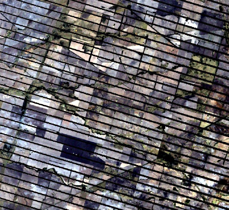
Before:
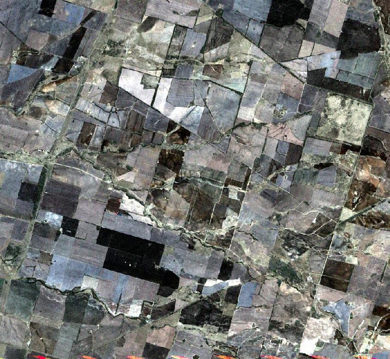
After local histogram matching and pansharpening:
- Mark as New
- Bookmark
- Subscribe
- Mute
- Subscribe to RSS Feed
- Permalink
- Report Inappropriate Content
You can also take a look here at the main NASA/USGS project
Filling the Gaps to use in Scientific Analysis
video on youtube
Gap fill Landsat 7 - SLC off project - YouTube
data here
SLC_off project.rar - Google Drive
And here external link to download the arcgis 9/10 toolbox
SLC_off project.rar — RGhost — file sharing
Take a look also at these good tutorials here
Integrated Geospatial Education and Technology Training Project
- Mark as New
- Bookmark
- Subscribe
- Mute
- Subscribe to RSS Feed
- Permalink
- Report Inappropriate Content
Hi Nicola,
Thanks for your response. I am having trouble getting the SLC_off project toolbox into ArcGIS. Could you talk me through how to do it?
Regards,
Laura
- Mark as New
- Bookmark
- Subscribe
- Mute
- Subscribe to RSS Feed
- Permalink
- Report Inappropriate Content
Laura, you need the original mask image file to blend with the SLC_off image form the ETM+7 band. In the same way it work in Envi
- Mark as New
- Bookmark
- Subscribe
- Mute
- Subscribe to RSS Feed
- Permalink
- Report Inappropriate Content
Sorry maybe I wasn’t clear I can’t actually get the toolbox into ArcGIS using the download from the link you provided (SLC_off project.rar — RGhost — file sharing <https://community.esri.com/external-link.jspa?url=http://rghost.net/6zRRxJTpB> ) Do I need to save it in a particular place? And what is the process for adding it to the ArcGIS toolbox?
Thanks,
Laura
- Mark as New
- Bookmark
- Subscribe
- Mute
- Subscribe to RSS Feed
- Permalink
- Report Inappropriate Content
Laura, in the archive are present 2 toolboxes, one for arcgis 9.x and one for arcgis 10.x, 2 pdfs.
Now seeing the old archive i forgot to add the 2 toolboxes..
Here a fresh new external link complete
gapfil_AG9x_10x.rar — RGhost — file sharing
Sorry for the troubles