- Home
- :
- All Communities
- :
- Products
- :
- Geoprocessing
- :
- Geoprocessing Questions
- :
- Does MakeLasDatasetLayer inherit an enabled surfac...
- Subscribe to RSS Feed
- Mark Topic as New
- Mark Topic as Read
- Float this Topic for Current User
- Bookmark
- Subscribe
- Mute
- Printer Friendly Page
Does MakeLasDatasetLayer inherit an enabled surface constraint from the Las Dataset?
- Mark as New
- Bookmark
- Subscribe
- Mute
- Subscribe to RSS Feed
- Permalink
- Report Inappropriate Content
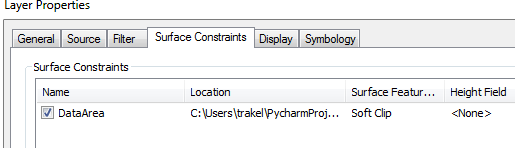
I have a Las Dataset with a surface constraint on it. The surface constraint is present and enabled on the las dataset
From this las dataset, I have created a layer which represents only the ground points. I wrote a python script to do this. I used the tool arcpy.management.MakeLasDatasetLayer followed by arcpy.SaveToLayerFile_management. However, I notice in arc map when examing the new layer which represents ground points that the suface constraint is present but not enabled.
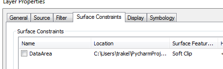
I have to open the properties of the layer which represents only ground points and enable the surface constraint from within arc map. Is there a way to do this programmatically? I have hundreds of these to do because my client's lidar data is organized into many folder representing many flights over many years.
Solved! Go to Solution.
Accepted Solutions
- Mark as New
- Bookmark
- Subscribe
- Mute
- Subscribe to RSS Feed
- Permalink
- Report Inappropriate Content
When you execute arcpy.management.MakeLasDatasetLayer, do you specify the surface_constraints or do you leave this as it is? According to the help:
The name of the surface constraint features that will be enabled in the layer. All constraints are enabled by default.
... the constraints (if specified) are enabled by default.
- Mark as New
- Bookmark
- Subscribe
- Mute
- Subscribe to RSS Feed
- Permalink
- Report Inappropriate Content
Now that I have a script to perform this, the problem seems to have gone away. I can't reliably reproduce this. I forgot to mention that I'm on arc gis 10.2.1.