- Home
- :
- All Communities
- :
- Products
- :
- Data Management
- :
- Data Management Questions
- :
- Split Polygon Layer by Values in Attributes
- Subscribe to RSS Feed
- Mark Topic as New
- Mark Topic as Read
- Float this Topic for Current User
- Bookmark
- Subscribe
- Mute
- Printer Friendly Page
- Mark as New
- Bookmark
- Subscribe
- Mute
- Subscribe to RSS Feed
- Permalink
- Report Inappropriate Content
Hi,
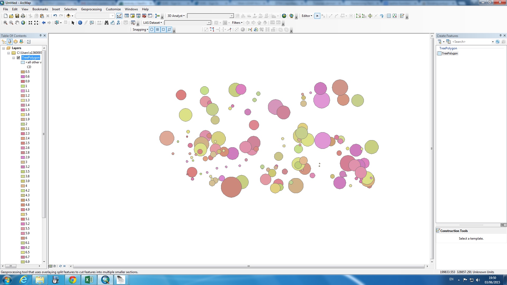
Does anyone know how to split this one shapefile into one single polygon based on each value of attributes. I have this polygon layer but with many attributes, like for example this one below is based on tree crown diameter size, the rest is like tree height etc. So right now i want to split it into individual tree polygon based on attribute crown size. Can anyone help me to solve this puzzle?
Thank you in advance!!
Solved! Go to Solution.
Accepted Solutions
- Mark as New
- Bookmark
- Subscribe
- Mute
- Subscribe to RSS Feed
- Permalink
- Report Inappropriate Content
- Mark as New
- Bookmark
- Subscribe
- Mute
- Subscribe to RSS Feed
- Permalink
- Report Inappropriate Content
I'm not certain I understand your question. Are you saying you want the polygons in this shapefile to become individual shapefiles, with each shapefile containing features with the same diameter size? If so, may I ask what is the purpose of doing that?
- Mark as New
- Bookmark
- Subscribe
- Mute
- Subscribe to RSS Feed
- Permalink
- Report Inappropriate Content
Hi Sephe,
Yes you get it right, i want all the polygon to become an individual
shapefiles. The polygon represent individual tree. I need to split it in
order to clip it with LiDAR point cloud data.
- Mark as New
- Bookmark
- Subscribe
- Mute
- Subscribe to RSS Feed
- Permalink
- Report Inappropriate Content
So the aim of the exercise is to give a height (either at ground or top height) for each tree using the Lidar information?
Does the lidar information only have one value for each geometric point?
If you are trying to determine the height of the trees, you should be able to do a join to the tree shapefile. Simply select "Maximum" as the attribute you wish to summarise it by (however if tree canopies overlap it may give you the height of the taller tree). Again this will depend on your lidar information (does it drill down through multiple tree canopies?)
If you are trying to determine the ground level (base height) of each tree then you will need to ensure that the lidar information only contains the ground elevations and then you could do a "average" summary (or convert the tree polygons to points and then a join between the two points ... this assumes that the tree bole is at the centroid of the circles though).
You shouldn't have to split the polygon into individual shapefiles though to do the processing. It really depends on the information you have available, and what your objectives are.
- Mark as New
- Bookmark
- Subscribe
- Mute
- Subscribe to RSS Feed
- Permalink
- Report Inappropriate Content
Hi Peter,
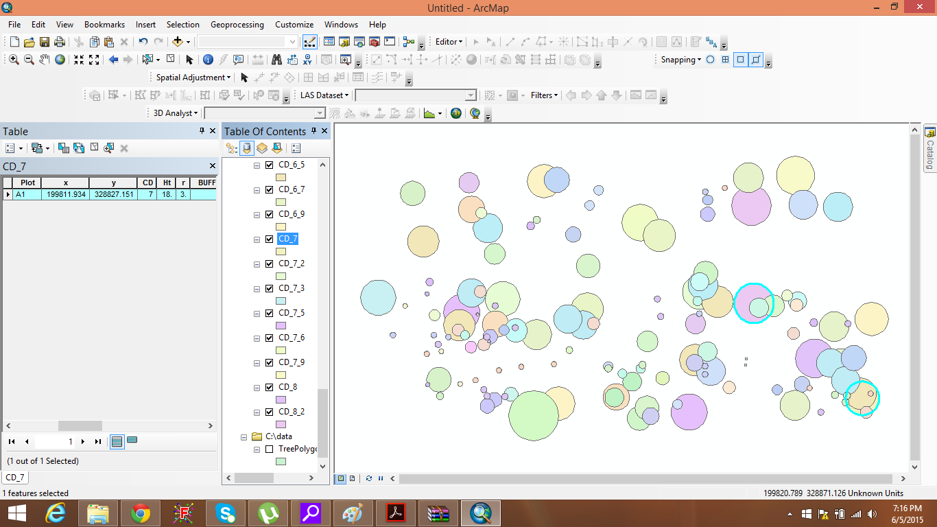
Thank you for your answer. The aim of this exercise is not to give a height for each tree, my tree plot study area is come from a dense intermingle crown tropical forest. So i want to generate an individual tree modelling. Right now i want to separate each of the polygon (crown) to clip with lidar point cloud. I managed to clip it using FUSION software, but because of the intermingle crowns (overlapped polygon) 18 of the tree plot are missed to clip. So that is why im looking for an alternative to split the polygon.
- Mark as New
- Bookmark
- Subscribe
- Mute
- Subscribe to RSS Feed
- Permalink
- Report Inappropriate Content

- Mark as New
- Bookmark
- Subscribe
- Mute
- Subscribe to RSS Feed
- Permalink
- Report Inappropriate Content
this is brilliant! im looking at it now. Thank you for the link
- Mark as New
- Bookmark
- Subscribe
- Mute
- Subscribe to RSS Feed
- Permalink
- Report Inappropriate Content
Problem solved!!! big thank you Ivan
- Mark as New
- Bookmark
- Subscribe
- Mute
- Subscribe to RSS Feed
- Permalink
- Report Inappropriate Content
Besides the ideas mentioned above, you could also split out the polygons into individual files with Modelbuilder.
-Note that there will need a unique ID for each polygon so it can be split out correctly. Depending upon your needs, this could be by crown size or by individual polygon (I wasn't sure from your posts above which is needed).
-The process is essentially Select and Export.
-An Iterator provides the means to loop through each record.
-Optionally, you could add an "In-line Variable" to distinctively name the new outputs.
Chris Donohue, GISP
- Mark as New
- Bookmark
- Subscribe
- Mute
- Subscribe to RSS Feed
- Permalink
- Report Inappropriate Content
Great! i will also look at this approach. Many thanks.