- Home
- :
- All Communities
- :
- Industries
- :
- Water Resources
- :
- Water Resources Questions
- :
- content in soils along a river
- Subscribe to RSS Feed
- Mark Topic as New
- Mark Topic as Read
- Float this Topic for Current User
- Bookmark
- Subscribe
- Mute
- Printer Friendly Page
content in soils along a river
- Mark as New
- Bookmark
- Subscribe
- Mute
- Subscribe to RSS Feed
- Permalink
- Report Inappropriate Content
Hi everyone,
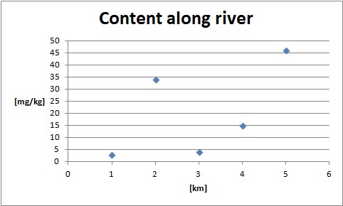
it´s my aim to produce a diagram which shows contents along a river (cf. attached example).
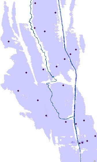
My initial situation: I have points of concentrations which are next to the river (cf. attached picture).
So far I only have had initial approaches but these do not lead me to my aim, yet. Anyway, maybe some inspiration:
- Segmentation of river
- Creation of buffers around these segments
- Assign points to buffered segment (Problems: 1. maybe several points in one segment 2. A point might be in two overlaying buffers)
Maybe there´s a possibility to pull the concentrations perpendicular to the river?
Thanks in advance!
- Mark as New
- Bookmark
- Subscribe
- Mute
- Subscribe to RSS Feed
- Permalink
- Report Inappropriate Content
Hi Mathias,
You can go for interpolation technique using the points of concentration. The output will be a grid data (Raster) where each pixel value would reflect the concentration of the material. You could repeat the same process with the values of different soil components.
Then you could symbolize the grid data appropriately (classified or stretched), so that they reflect the concentration of the soil components.
What else do you require?
Think Location
- Mark as New
- Bookmark
- Subscribe
- Mute
- Subscribe to RSS Feed
- Permalink
- Report Inappropriate Content
Hi Jayanta,
Thanks for your reply, but I´d like to use the real measurement points, not the estimated content.