- Home
- :
- All Communities
- :
- Products
- :
- Mapping
- :
- Mapping Questions
- :
- Need help aligning a DEM with georeferenced imager...
- Subscribe to RSS Feed
- Mark Topic as New
- Mark Topic as Read
- Float this Topic for Current User
- Bookmark
- Subscribe
- Mute
- Printer Friendly Page
Need help aligning a DEM with georeferenced imagery & GCPs
- Mark as New
- Bookmark
- Subscribe
- Mute
- Subscribe to RSS Feed
- Permalink
- Report Inappropriate Content
Hello,
I'm working on a project where I've taken point cloud data obtained from a terrestrial laser scanner and converted it to a DEM using Lastools. I've also got aerial imagery taken from a helikite that has been georeferenced with ground control points. I now need to overlay those images onto the DEM so I can create a semi-realistic terrain model.
My problem is that the DEM and the georeferenced images don't line up even though they all have the same coordinate system. I know I could georeference the DEM to the ground control points to fix it, but the DEM doesn't have any features that I could actually match to the control points.
Does anyone have any advice that would help me get around this issue?
Thanks,
John
Solved! Go to Solution.
Accepted Solutions
- Mark as New
- Bookmark
- Subscribe
- Mute
- Subscribe to RSS Feed
- Permalink
- Report Inappropriate Content
I would agree. Based on all of the info you have provided, I would conclude that your spatial reference woes begin with the raw point cloud. I don't know much about terrestrial lidar scanners but if I make the assumption that the scanner sits at the center of the data extent at an origin of 0,0 and the units are meters, the extent values in your last screenshot would give you a point cloud covering an area of ~217 x ~145 meters. This is similar to the size of your DEM that initiated this discussion so the extent values being reported make sense, just not in a geographic way. I guess what you need to do is figure out how to use the Cyclone software to translate the raw scan coordinates to real-world geographic coordinates.
- Mark as New
- Bookmark
- Subscribe
- Mute
- Subscribe to RSS Feed
- Permalink
- Report Inappropriate Content
Hi John,
This looks like a tough one but perhaps someone with experience processing lidar data and/or georeferencing elevation surfaces will have some useful insight. I am not sure I will be able to provide any fruitful suggestions but I am curious about a few things.
1. What are we talking about in terms of the character and amount of misalignment between the images and the DEM?
2. Does the point cloud also exhibit the alignment issue? You could throw the LAS file into an LAS Dataset and compare it to the imagery to determine this.
3. I have never tried this but do you have any other correctly aligned elevation surfaces you could compare the DEM to? Or even a digital USGS topo? Perhaps if a reference surface has high enough resolution, you could use some distinctive terrain features found in both surfaces for georeferencing purposes.
- Mark as New
- Bookmark
- Subscribe
- Mute
- Subscribe to RSS Feed
- Permalink
- Report Inappropriate Content
//1. What are we talking about in terms of the character and amount of misalignment between the images and the DEM?//
The images and the DEM don't seem to appear anywhere near each other. When I try and view the entire extent it takes me from 1:627 to 1:18,559,691.
//2. Does the point cloud also exhibit the alignment issue? You could throw the LAS file into an LAS Dataset and compare it to the imagery to determine this.//
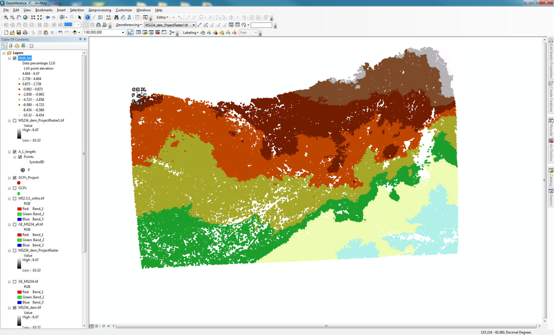
I put the las file into a las dataset and there were still major alignment issues. As you can see in the picture the GCPs are in the top left corner of the lidar data. This is a closer match than the actually DEM though.
//3. I have never tried this but do you have any other correctly aligned elevation surfaces you could compare the DEM to? Or even a digital USGS topo? Perhaps if a reference surface has high enough resolution, you could use some distinctive terrain features found in both surfaces for georeferencing purposes.//
The DEM that I've created is only about 250x130 meters and there aren't really any distinguishing features from it since it's a desert in Utah.
- Mark as New
- Bookmark
- Subscribe
- Mute
- Subscribe to RSS Feed
- Permalink
- Report Inappropriate Content
Are you sure the projection and datum have been defined correctly for both layers? A common mistake is for people to attempt to change a projection using the define projection tool. This will project the original coordinates into the wrong place, instead of changing the coordinates to the new projection. How different are they. If it's less than a 100 feet or so, it's probable the wrong datum.
- Mark as New
- Bookmark
- Subscribe
- Mute
- Subscribe to RSS Feed
- Permalink
- Report Inappropriate Content
The difference is much greater than 100 ft. 100 miles would be a closer estimate.
Is there a way to change it to a new projection without using the define project tool?
Maybe these screen shots will help
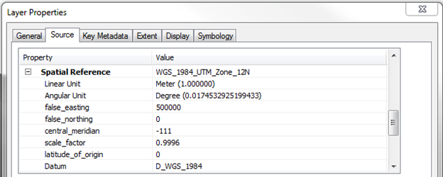
Spatial Reference & Extent for DEM:

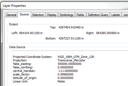
GCS for the GCPs

- Mark as New
- Bookmark
- Subscribe
- Mute
- Subscribe to RSS Feed
- Permalink
- Report Inappropriate Content
Hi John,
Thanks for all the details and screenshots. It definitely appears to be a spatial reference definition issue and I am seeing evidence of this in the screenshots you posted.
1. For the screenshot of the LAS Dataset, it is covering most of the earth which suggests that the units of the defined coordinate system are not the units used to actually record the coordinates of the lidar points.
2. For your DEM, the spatial reference (UTM) uses linear units of meters but its extent appears to be reported in decimal degrees. It should also be noted that according to the extent, the DEM covers most of the earth.
The GCP info appears normal with the extent values being compatible with its spatial reference.
- Do you know what coordinate system the lidar data was provided in?
- Did you use UTM Zone 12 for the LAS Dataset?
- What is the coordinate system of the data frame for the LAS Dataset screenshot?
I think the issue is that the wrong spatial reference was used for creating the DEM from the lidar data and also for creating the LAS Dataset in the screenshot above. Another possibility is that the spatial reference reported in the header of the LAS file is not the correct spatial reference of the lidar points.
- Mark as New
- Bookmark
- Subscribe
- Mute
- Subscribe to RSS Feed
- Permalink
- Report Inappropriate Content
The lidar data was originally a point cloud that I exported as a .pts file from Cyclone. It was basically xyz format using meters. I don't know if it actually had a defined coordinate system.
I did not use UTM Zone 12 for the las dataset. I can't seem to give it a projection since it doesn't appear as an option when I use the project tools in arcmap.
The I made the coordinate system GCS_WGS_1984 in the las dataset from the properties dialog in arccatalog. 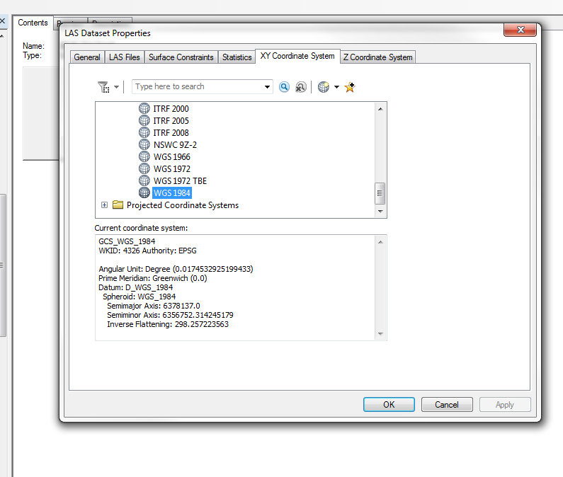
But it didn't really seem to affect the las file within the dataset.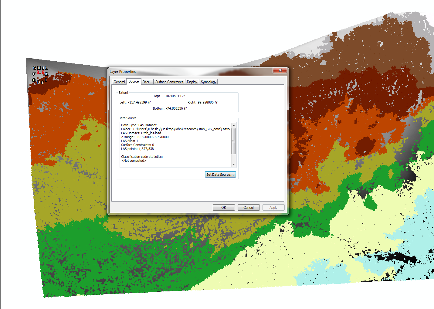
I now see that the spatial reference is probably the main issue here, but I'm not sure on how the problem can be addressed.
- Mark as New
- Bookmark
- Subscribe
- Mute
- Subscribe to RSS Feed
- Permalink
- Report Inappropriate Content
Hi John,
Specifying the coordinate system under the properties of the LAS Dataset via Catalog is the correct way for the LAS Dataset. Desktop does not contain a tool that can project LAS files directly but there are some third-party tools that can do this. BUT, as Sephe has pointed out, you don't need to project the lidar data, instead, you need to define the correct projection. Esri has supplementary tools that will allow you to define the projection for an LAS file but you would first need to know what it should be. If the data was not collected in real-world coordinate space using a geographic or projected coordinate system, then I am not sure of a way you can address that.
- When you add the LAS file to the LAS Dataset, what does the coordinate system under the "XY Coordinate System" tab default to?
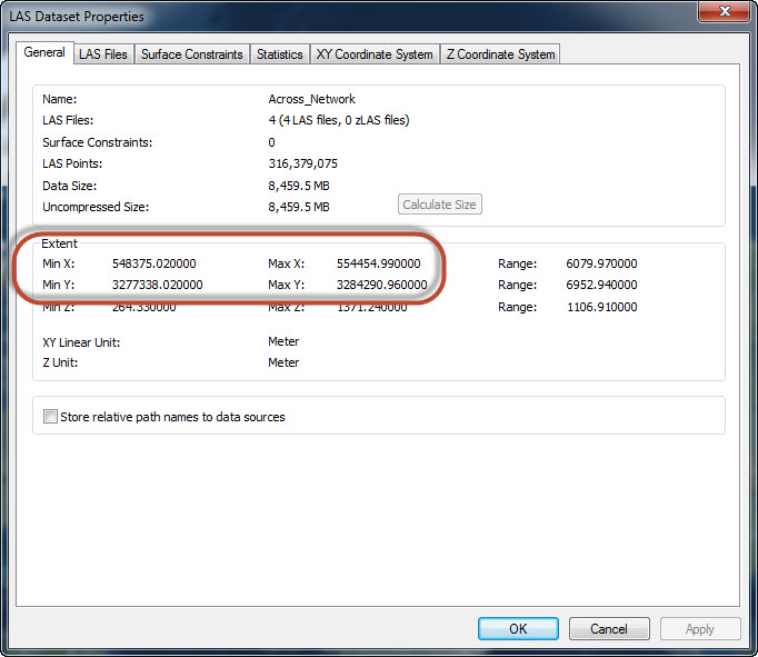
- What are the default extent values under the "General" tab? Below is a screenshot of what I am referring to.
- Mark as New
- Bookmark
- Subscribe
- Mute
- Subscribe to RSS Feed
- Permalink
- Report Inappropriate Content
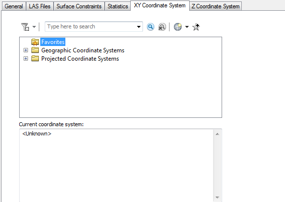
The coordinate system defaults to unknown
And the extent values are shown below.
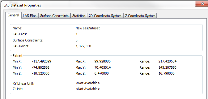
This may be an issue with the processing of the scan data. It looks like I may have to go back a couple of steps and attempt to assign a coordinate system to the raw data.
- Mark as New
- Bookmark
- Subscribe
- Mute
- Subscribe to RSS Feed
- Permalink
- Report Inappropriate Content
I would agree. Based on all of the info you have provided, I would conclude that your spatial reference woes begin with the raw point cloud. I don't know much about terrestrial lidar scanners but if I make the assumption that the scanner sits at the center of the data extent at an origin of 0,0 and the units are meters, the extent values in your last screenshot would give you a point cloud covering an area of ~217 x ~145 meters. This is similar to the size of your DEM that initiated this discussion so the extent values being reported make sense, just not in a geographic way. I guess what you need to do is figure out how to use the Cyclone software to translate the raw scan coordinates to real-world geographic coordinates.