- Home
- :
- All Communities
- :
- Products
- :
- ArcGIS GeoStatistical Analyst
- :
- ArcGIS GeoStatistical Analyst Questions
- :
- Geostatistics analysis for non-geographic data in ...
- Subscribe to RSS Feed
- Mark Topic as New
- Mark Topic as Read
- Float this Topic for Current User
- Bookmark
- Subscribe
- Mute
- Printer Friendly Page
Geostatistics analysis for non-geographic data in ArcGIS
- Mark as New
- Bookmark
- Subscribe
- Mute
- Subscribe to RSS Feed
- Permalink
- Report Inappropriate Content
Hi All,
I am a biologist. Currently, I am trying to use a geostatistics algorithm (kriging algorithm) to analyze my experimental data - to illustrate how protein behaves and functions in the Cellular 'geographic map'. So I don't have latitude and longitude values, instead, I have a set of (X,Y,Z) data indicating different function of a protein at different cellular locations. The scale of the (X,Y) is quite different from latitude and longitude. The question I am asking is - can I analyze non-latitude and longitude value in the Arcmap software? How can I do that?
Thanks,
Chao.
Solved! Go to Solution.
Accepted Solutions
- Mark as New
- Bookmark
- Subscribe
- Mute
- Subscribe to RSS Feed
- Permalink
- Report Inappropriate Content
Sorry Chao, I replied on my phone last time, and I guess the link didn't get attached like I thought. Anyway, it sounds like you know how to convert the x/y values, no problem. If you're not concerned with preserving the actual locations of the points, then I would scale the y values by multiplying by some factor. In your case probably 1000.
- Mark as New
- Bookmark
- Subscribe
- Mute
- Subscribe to RSS Feed
- Permalink
- Report Inappropriate Content
I Don't see why not. Arcgis happily accepts custom coordinates. Have you tried importing your data yet, and creating features with z values from your table? I'm curious to know the result.
- Mark as New
- Bookmark
- Subscribe
- Mute
- Subscribe to RSS Feed
- Permalink
- Report Inappropriate Content
IF your not familiar with the process, the following article will help. The last section at the bottom explains how to convert a table with z values. I'm Not sure what you would do for picking a coordinate system. Depending on your scale you could fake it in meters.
- Mark as New
- Bookmark
- Subscribe
- Mute
- Subscribe to RSS Feed
- Permalink
- Report Inappropriate Content
Thanks for your reply, Sephe. Where is the 'following article' you mentioned in your post? I can't find it.
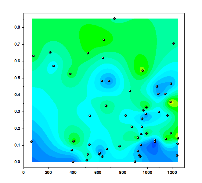
I tried my data in ArcGis. However, I found my X and Y scale are very different. The X-scale is from 0 to 1278. But the Y-scale is from 0 to 1. Thus the map in ArcGis is just a very narrow bar. Can I modify the X and Y scale in ArcGis? This is the first time I am using ArcGis......I have no idea how to modify the X and Y coordinates.
In fact, I used another software called 'Originpro' to performed Kriging algorithm for my data. The result is attached below. However, this software does not output the semivariogram or 'confidence map', so I want to use ArcGis to produce semivariogram or prediction standard error.
Thanks
Chao.
- Mark as New
- Bookmark
- Subscribe
- Mute
- Subscribe to RSS Feed
- Permalink
- Report Inappropriate Content
Sorry Chao, I replied on my phone last time, and I guess the link didn't get attached like I thought. Anyway, it sounds like you know how to convert the x/y values, no problem. If you're not concerned with preserving the actual locations of the points, then I would scale the y values by multiplying by some factor. In your case probably 1000.
- Mark as New
- Bookmark
- Subscribe
- Mute
- Subscribe to RSS Feed
- Permalink
- Report Inappropriate Content
Thanks. I think that would work.
