- Home
- :
- All Communities
- :
- User Groups
- :
- Coordinate Reference Systems
- :
- Questions
- :
- Local Coordinate Systems
- Subscribe to RSS Feed
- Mark Topic as New
- Mark Topic as Read
- Float this Topic for Current User
- Bookmark
- Subscribe
- Mute
- Printer Friendly Page
Local Coordinate Systems
- Mark as New
- Bookmark
- Subscribe
- Mute
- Subscribe to RSS Feed
- Permalink
- Report Inappropriate Content
Hi All,
I am working on a project that is in a local coordinate system (mine grid) and I am interested in learning about best practices on moving data between (to and from) mine grid and real world coordinates (NAD27 State Plane New Mexico West). The mine grid is only a slight shift from NAD27 State Plane New Mexico West. There is no change in scale or rotation, only shift.
I have an AutoCAD file setup that shows a set of points in NAD27 State Plane New Mexico West and the same points in mine grid. This file has been used to move AutoCAD data between the two coordinate systems. Is this the best approach for transforming .DWG files?
Also, what is the best approach to incorporate shapefiles that are in either NAD83 or NAD27 State Plane coordinate systems? Is the best plan of action to set up a mine grid .PRJ file?
Curious to see how others have approached working in local coordinate systems.
Many Thanks,
Jason
Solved! Go to Solution.
Accepted Solutions
- Mark as New
- Bookmark
- Subscribe
- Mute
- Subscribe to RSS Feed
- Permalink
- Report Inappropriate Content
It is set up in the coordinate definition of the data. Once described properly, yes, you can leave your data "as is", and ArcMap can project it (or any other data) to whatever you want.
What are the offsets?
Start off with ArcCatalog, navigate to your mine data cad file, if there is no current spatial reference applied, go and select your NAD27 state plane, right click on it, 3rd option is to copy and modify. Give it a new name like "NAD27 State Plane NM - mine local grid" or something. Edit the X & Y shifts to the correct numbers. Viola. Put it in your favourites. If you use the normal file explorer, you will see that there is now a new prj file next to the CAD file (with the same base name).
- Mark as New
- Bookmark
- Subscribe
- Mute
- Subscribe to RSS Feed
- Permalink
- Report Inappropriate Content
By "shift" do you mean an offset or truncation of X or Y axes or both?
If you know what the offset is you can set up a "local" version of NAD27 stateplane NM west, with the X/YShift entered into the False_Easting / Northing values.
- Mark as New
- Bookmark
- Subscribe
- Mute
- Subscribe to RSS Feed
- Permalink
- Report Inappropriate Content
By shift I mean an offset.
So should the transformation be set up in the MXD, and not the data? Ideally, I would like to leave all shapefiles in their native coordinate system. Can you provide some clarity when you say to set up a "local" version of NAD 27 state plane NM West? Would this be done in an MXD, a .PRJ file, or a new shapefile?
Thank for you the reply!
Jason
- Mark as New
- Bookmark
- Subscribe
- Mute
- Subscribe to RSS Feed
- Permalink
- Report Inappropriate Content
It is set up in the coordinate definition of the data. Once described properly, yes, you can leave your data "as is", and ArcMap can project it (or any other data) to whatever you want.
What are the offsets?
Start off with ArcCatalog, navigate to your mine data cad file, if there is no current spatial reference applied, go and select your NAD27 state plane, right click on it, 3rd option is to copy and modify. Give it a new name like "NAD27 State Plane NM - mine local grid" or something. Edit the X & Y shifts to the correct numbers. Viola. Put it in your favourites. If you use the normal file explorer, you will see that there is now a new prj file next to the CAD file (with the same base name).
- Mark as New
- Bookmark
- Subscribe
- Mute
- Subscribe to RSS Feed
- Permalink
- Report Inappropriate Content
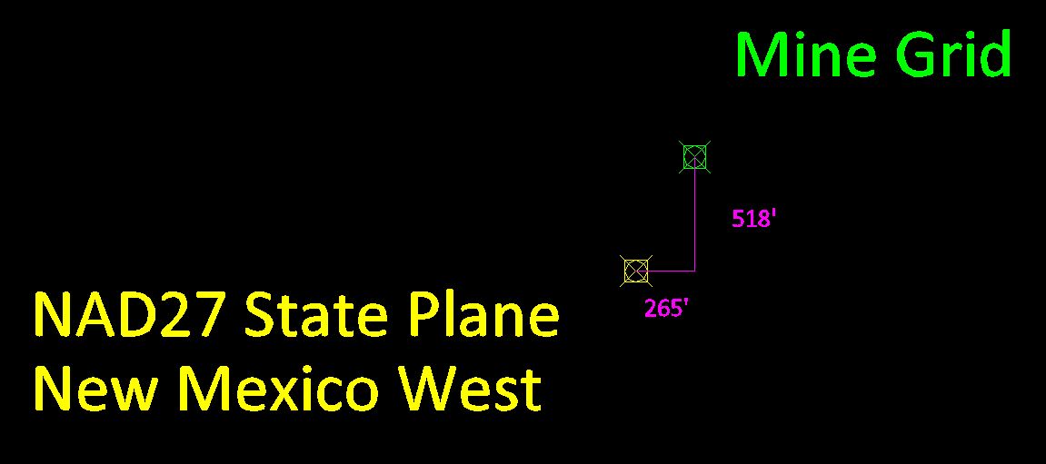
To shift the data from NAD27 State Plane NM West to Mine Grid the following shift must be used:
East: 265 ft
North: 518 ft
After trying the method you outlined I ran into an issue where I'm still noticing a shift. The method you mentions makes sense in theory but I'm going wrong somewhere.
I have attached an image showing the shift I need to get into Mine Grid. Correct me if I'm wrong but I assumed I would be adding 265 ft to the Easting and adding 518 ft to the Northing of my NAD27 Mine Grid coordinate system. However, this doubled the shift in the opposite direction. Should I subtract these values from NAD27 State Plane New Mexico West to get to Mine Grid? Once this is complete, is it correct to leave my Data Frame in NAD27 State Plane NM West and my shapefiles would have Mine Grid assigned as their coordinate system?
Also, would I run into issues if I export out these shapefiles which have been assigned the Mine Grid coordinate system to CAD?
The typical workflow will be to receive data in NAD27 State Plane NM West, but my map documents and all data I export to CAD should be in Mine Grid.
Thanks for all of your advice on this!
Jason
- Mark as New
- Bookmark
- Subscribe
- Mute
- Subscribe to RSS Feed
- Permalink
- Report Inappropriate Content
Jason,
if the "shift" doubled, then obviously make them negative and subtract them from the already assigned XShift/YShift!
Once you have the input CAD data correctly defined using this modified Stateplane (now called Mine Grid or something), then everything should be fine. You can keep it like that. If you want to export stuff out you can use either the coord sys of the data (Mine Grid?) or the coord sys of the data frame (or anything else you can think of).
And yes, the book mentioned by Margaret Maher is very good at explaining these sort of issues.
No, I would not use a links file to shift the data. This should only be used if all else fails, ie if the "mine grid" is in some unfathomably complex shifted rotated relationship to the real world coordinates.
- Mark as New
- Bookmark
- Subscribe
- Mute
- Subscribe to RSS Feed
- Permalink
- Report Inappropriate Content
Thanks, Neil.
I think I was confused as to why to subtract the "shift" rather than to add it to the NAD27 coordinate system, given the orientation of the shift. I will play around with this method some more. Thanks again for your help.
- Mark as New
- Bookmark
- Subscribe
- Mute
- Subscribe to RSS Feed
- Permalink
- Report Inappropriate Content
When I worked with New Mexico Mines and local systems, I would use the same method Neil mentioned. Some 'Shift' will inevitably exist, unless you physically transform the data using a georeferencing type method. This is due to ellipsoid and spheroid variations and conflicts with Datums, that weren't previously accounted for in most of those local systems.
To combat the shifting, I would use a 'Links' file to actually move the data. The links file would consist of known points and newly surveyed points depending upon the accuracy I needed. I know that is not what you want to do though.
Also, check out Margaret Maher's book from Esri Press. Its called "Lining Up Data". it is an invaluable resource for me. It should provide you with some insights moving forward.
- Mark as New
- Bookmark
- Subscribe
- Mute
- Subscribe to RSS Feed
- Permalink
- Report Inappropriate Content
Thanks for the reply, James. I know there are various methods to move to/from local coordinate systems and I was hoping to see what methods others have had success with. The approach mentioned above seems to be a good option as I will be needing to move data to and from mine grid on a regular basis. I am looking for a consistent, streamlined approach to dealing with this.
Thanks for the suggestion on the book. I will give it a read!