- Home
- :
- All Communities
- :
- Products
- :
- Imagery and Remote Sensing
- :
- Imagery Questions
- :
- Arcpad Raster
- Subscribe to RSS Feed
- Mark Topic as New
- Mark Topic as Read
- Float this Topic for Current User
- Bookmark
- Subscribe
- Mute
- Printer Friendly Page
- Mark as New
- Bookmark
- Subscribe
- Mute
- Subscribe to RSS Feed
- Permalink
- Report Inappropriate Content
Alright, I don't know much about Raster's. I have downloaded some Tiff's from our states website for some Aerial Photo's to run in ArcPad. When I used the original files they gave me an error that (after I looked it up) told me that it wasn't "compatible" with ArcPad. I was informed that I had to allow ArcPad Data manager to convert them into a format that would work. The original Tiff files are around 60 MB, but when I have ArcPad Data Manager convert them, the size jumps to around 400MB to 600MB, which becomes way to big for us to use.
Is there a way to tone down the conversion rate, or somehow get them to a much smaller size?
FYI, doing the conversion where it keeps the original file, doesn't work. It still gives me the original error. Thanks.
Solved! Go to Solution.
Accepted Solutions
- Mark as New
- Bookmark
- Subscribe
- Mute
- Subscribe to RSS Feed
- Permalink
- Report Inappropriate Content
Hi Devin,
I pulled down one of the source .TIF Raster Datasets from the .FTP site and had a few things that I wanted to pass along. While the source and processed output datasets are both .TIFs the compression algorithms used to reduce their size on disk is different. If you load one of the source raster datasets into ArcMap and navigate to the dataset properties, you will notice that the compression utilized is JPEG YCbCr.
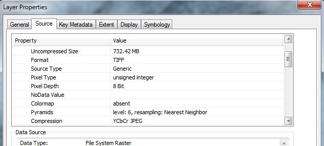
This compression algorithm is utilized for 8-Bit 3-Band natural color imagery which is exactly what these Raster Datasets are. This compression is lossy and converts the image to a different spectral domain which improves compression however this cannot be decompressed by numerous GIS applications. Unfortunately, these datasets are not supported in ArcPad. ArcPad is a mobile application and as such does not have access to the full suite of GDAL.dlls as is the case with ArcMap. Also keep in mind that the reason the processed datasets grew by a large factor is that LZW is a lossless compression that under most circumstances can only achieve a compression factor of 2:1. This would explain the exponential file growth on disk. You can use the ArcPad Data Manager to check the source .TIFs out to a background image. My testing revealed that a Single Raster Dataset exported to a JPEG2000 Background Image produced an .APM roughly 500MB in total size. This will obviously limit the ability to work with these datasets in the field on a mobile device.
- Mark as New
- Bookmark
- Subscribe
- Mute
- Subscribe to RSS Feed
- Permalink
- Report Inappropriate Content
Convert your images to TIFF with LZW compression.
The ArcPad Team Blog: Raster Tips # 1 - Choosing a raster format
ArcGIS Help (10.2, 10.2.1, and 10.2.2)
Hope this information is helpful
Kishor.
- Mark as New
- Bookmark
- Subscribe
- Mute
- Subscribe to RSS Feed
- Permalink
- Report Inappropriate Content
Some of this was helpful, but I'm still nowhere. I have 253 Tiff's to convert. So even if I could get it to work as it says in the blog (Which I kind of did with major degradation in quality), I would have to repeat it 253 times for each file.
I tried converting the Current Tiff files into Tiff with LZW compression, but it still makes them 500-650MB in size.
How can you go from a very high quality tiff to a way lower quality tiff and increase the file size 10x? As I said, I do not know much about working with Rasters.
If you are able to help a little more in depth, you can grab one of the files from ftp://ftp.agrc.utah.gov/HRO2012/ .
- Mark as New
- Bookmark
- Subscribe
- Mute
- Subscribe to RSS Feed
- Permalink
- Report Inappropriate Content
Hi Devin,
I pulled down one of the source .TIF Raster Datasets from the .FTP site and had a few things that I wanted to pass along. While the source and processed output datasets are both .TIFs the compression algorithms used to reduce their size on disk is different. If you load one of the source raster datasets into ArcMap and navigate to the dataset properties, you will notice that the compression utilized is JPEG YCbCr.
This compression algorithm is utilized for 8-Bit 3-Band natural color imagery which is exactly what these Raster Datasets are. This compression is lossy and converts the image to a different spectral domain which improves compression however this cannot be decompressed by numerous GIS applications. Unfortunately, these datasets are not supported in ArcPad. ArcPad is a mobile application and as such does not have access to the full suite of GDAL.dlls as is the case with ArcMap. Also keep in mind that the reason the processed datasets grew by a large factor is that LZW is a lossless compression that under most circumstances can only achieve a compression factor of 2:1. This would explain the exponential file growth on disk. You can use the ArcPad Data Manager to check the source .TIFs out to a background image. My testing revealed that a Single Raster Dataset exported to a JPEG2000 Background Image produced an .APM roughly 500MB in total size. This will obviously limit the ability to work with these datasets in the field on a mobile device.
- Mark as New
- Bookmark
- Subscribe
- Mute
- Subscribe to RSS Feed
- Permalink
- Report Inappropriate Content
Excellent! Thanks so much! That helps a lot and answers my questions! Thanks so much for taking that time!