- Home
- :
- All Communities
- :
- Developers
- :
- JavaScript Maps SDK
- :
- JavaScript Maps SDK Questions
- :
- More Questions about Select Routes using Geocoded ...
- Subscribe to RSS Feed
- Mark Topic as New
- Mark Topic as Read
- Float this Topic for Current User
- Bookmark
- Subscribe
- Mute
- Printer Friendly Page
More Questions about Select Routes using Geocoded address and 1/4 Mile Buffer
- Mark as New
- Bookmark
- Subscribe
- Mute
- Subscribe to RSS Feed
- Permalink
- Report Inappropriate Content
Robert,
I do have a few other questions (3) about my complete code for this project and was wondering if you wouldn't mind a little further guidance.
One:
I have a home button command that I'm trying to get to clear out the results from the results div tag. Here is what I have that doesn't seem to work with this particular application. It gives me an error finding the (results.rows). Any ideas how to clear out this data?
Here is my goHome.js
//
Resets the Map to its initial state with no routes selected and accordian pane back to default
function goHome(){
// Acitivates the Legend Accordian Tab
var container = dijit.byId("container");
container.selectChild("legendPane", true);
// This will remove old values in Routes Within 1/4 Mile Div Tag
var results = document.getElementById("results");
var rowCount = results.rows.length;
for (var x=rowCount-1; x>0; x--)
{
results.deleteRow(x);
}
// Removes Any simpleLineSymbols and Any simplePointSymbols
map.graphics.clear();
// Closes any open infoWindows
map.infoWindow.hide();
// Zoom to Map Extent
map.setExtent(mapExtent);
// Clears any address entered into Address Search Box
document.getElementById("search_input").value="";
}
TWO:
When creating my busRoutes layer, I don't want the map to allow users to click anywhere and it say (No Information). I also tried to use the on mouse-over for this layer and can't seem to get it to work. Any ideas on this one.
//
Creating the Template for Bus Route
busRouteContent = ("Name", "<tr><td><a
href='${TRAN_GD_PDF}'
target='_blank'>${NAME}</a></tr></td>");
busRouteTemplate = new esri.InfoTemplate;
busRouteTemplate.setContent(busRouteContent);
busRouteTemplate.setTitle("Bus
Route: ${ROUTE}");
busRoutes = new ArcGISDynamicMapServiceLayer("http://gis.rtcsnv.com/arcgis/rest/services/Maps/PROD_ADA_CERT/MapServer",
{id:"Routes"});
busRoutes.setInfoTemplates({
2: { infoTemplate: busRouteTemplate
}
});
busRoutes.setVisibleLayers([2]);
busRoutes.on("mouse-over", function()
{
map.setMapCursor("pointer");
});
busRoutes.on("mouse-out", function()
{
map.setMapCursor("default");
});
THREE:
In my Legend list this dynamic map service layers shows up using the application name and then its layer name. How can I remove the application part from the layer name. It currently shows up as: PROD_ADA_CERT RTC Bus Routes. I only want it to say RTC Bus Routes.
Solved! Go to Solution.
Accepted Solutions
- Mark as New
- Bookmark
- Subscribe
- Mute
- Subscribe to RSS Feed
- Permalink
- Report Inappropriate Content
John,
One. The simplest way to clear the results div is to use a line like this
dojo.byId("results").innerHTML = '';Two. As the layer is added as a dynamic map service layer and not a featurelayer you do not get mouse events like mouse over and mouse out. The click event actually launches a querytask under the hood of the API to see if they have clicked on your features.
Three. The easiest way if to add this to the css
.esriLegendLayerLabel
    {
        display: none;
    }
- Mark as New
- Bookmark
- Subscribe
- Mute
- Subscribe to RSS Feed
- Permalink
- Report Inappropriate Content
Robert,
One: Perfect thank you.
Two: I removed the on.mouse events as they are no longer needed, Thank you.
Three: When I added this to my css it removed the RTC Bus Routes label portion and left the Application name: PROD_ADA_CERT instead. I'm not quite sure how to fix this as I only want the layer name (RTC Bus Routes). Is there a way for me to manually name it somehow?
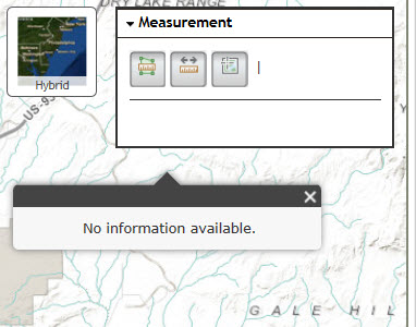
Also, is there a way to remove the (No Information Available) popup when the user clicks around on the map? I have the measurement tool added to this application and when a user is measuring distance to walk to a bus stop this popup (No Information Available) pops up every time they click on the map.
Thank you again for the continued help. Your help is greatly appreciated.
- Mark as New
- Bookmark
- Subscribe
- Mute
- Subscribe to RSS Feed
- Permalink
- Report Inappropriate Content
John,
Three. Not that I am aware of.
Measure widget. When you activate the measure widget you need to use
map.setInfoWindowOnClick(false);
and when the measure widget is done turn it back on
map.setInfoWindowOnClick(true);
- Mark as New
- Bookmark
- Subscribe
- Mute
- Subscribe to RSS Feed
- Permalink
- Report Inappropriate Content
Robert,
Regarding the measurement widget. I simply have the following code below. I'm not sure where I would go about adding the code you supplied above. Again, thanks so much 
var measurement = new Measurement({
map: map
}, dom.byId("measurementDiv"));
measurement.startup();
- Mark as New
- Bookmark
- Subscribe
- Mute
- Subscribe to RSS Feed
- Permalink
- Report Inappropriate Content
John,
In that case it is a little more:
     var measurement = new Measurement({
       map: map
     }, dom.byId("measurementDiv"));
     aspect.after(measurement, 'setTool', lang.hitch(this, function() {
        if (measurement.activeTool) {
          this.map.setInfoWindowOnClick(false);
        } else {
          this.map.setInfoWindowOnClick(true);
        }
      }));
      measurement.startup();
and of course you will need to require dojo/aspect
- Mark as New
- Bookmark
- Subscribe
- Mute
- Subscribe to RSS Feed
- Permalink
- Report Inappropriate Content
NEVERMIND, FIXED IT.
Had to add the "dojo/_base/lang", lang as well. Duh!!!!!!!!!!!!
Robert,
Didn't want to bug you but I added this to my code and it's not working out for me, tried for most of the day now to figure it out with no luck. Also, when I added this I lost some functionality that I have with Layers that I have a checkbox associated with. I did add the "dojo/aspect", aspect as well.
Also, the Measurement tool allows me to select all of the values and none of them actually work.
//
If user wants to see Paratransit Service Area this checks the checkbox to see if they turn it on or off
document.getElementById("checkBox0").onclick = function() {
if (this.checked) {
paraSvcArea.show();
}
else {
paraSvcArea.hide();
}
};
// If user wants to see Flexible Demand Response (FDR) Service Area this checks the checkbox to see if they turn it on or off
document.getElementById("checkBox1").onclick = function() {
if (this.checked) {
fdrSvcArea.show();
}
else {
fdrSvcArea.hide();
}
};
// If user wants to see Silverstar Routes this checks the checkbox to see if they turn it on or off
document.getElementById("checkBox2").onclick = function() {
if (this.checked) {
silverstar.show();
}
else {
silverstar.hide();
}
};
- Mark as New
- Bookmark
- Subscribe
- Mute
- Subscribe to RSS Feed
- Permalink
- Report Inappropriate Content
John,
Sorry I forgot about that.
- Mark as New
- Bookmark
- Subscribe
- Mute
- Subscribe to RSS Feed
- Permalink
- Report Inappropriate Content
Robert,
No worries at all you have been beyond helpful. I've got to start a new discussion soon on a few other questions that I have that perhaps I'll be able to once again thank you.
Thanks again for all the help, it's greatly appreciated. Have a great day.