- Home
- :
- All Communities
- :
- Industries
- :
- Water Resources
- :
- Water Resources Questions
- :
- LS factor map
- Subscribe to RSS Feed
- Mark Topic as New
- Mark Topic as Read
- Float this Topic for Current User
- Bookmark
- Subscribe
- Mute
- Printer Friendly Page
- Mark as New
- Bookmark
- Subscribe
- Mute
- Subscribe to RSS Feed
- Permalink
- Report Inappropriate Content
I am presently working on my in-service Ph. D. project work related to sediment yield estimation through RS and GIS Techniques.
1) I wish to estimate time of concentration by " ARCHYDRO 10.2.2 TOOLS ( H & H modeling) but don't know which steps should follow and
2) I have prepared stepwise following maps in ARCGIS 10.2.2.
1. Digitization of Contour, Elevation Points and Watershed Boundary from toposheet..
2. 20 m DEM through "topo to raster" interpolation method.
3. Filled DEM
4. Flow Direction Map
5. Flow Accumulation map
6. Slope map
7. LS factor map using "Raster Calculator" and LS factor formula.
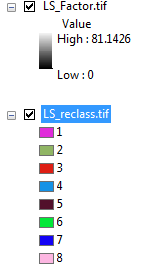
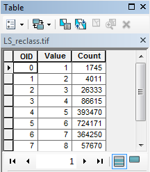
The LS factor map is prepared but the attribute table is not displayed. I don't know how to extract the LS factor values from the map. The attribute values are not displayed from DEM to LS factor map.
- Mark as New
- Bookmark
- Subscribe
- Mute
- Subscribe to RSS Feed
- Permalink
- Report Inappropriate Content
Hi Arun,
The LS factor would be displayed by the pixel values of your LS_Factor raster data.
To build a Raster attribute table, the data should be a Single Band Integer Raster Dataset. But your LS_Factor data is in Float.
You could try reclassifying the LS_Factor dataset into a number of desired classes. It will create a new output with an attribute table.
N.B.: Make a note of the range of values you are reclassifying in each class.
Hope it helps!
Thanks,
Jay
Think Location