- Home
- :
- All Communities
- :
- Products
- :
- ArcGIS Spatial Analyst
- :
- ArcGIS Spatial Analyst Questions
- :
- calculating directional derivative and the gradien...
- Subscribe to RSS Feed
- Mark Topic as New
- Mark Topic as Read
- Float this Topic for Current User
- Bookmark
- Subscribe
- Mute
- Printer Friendly Page
calculating directional derivative and the gradient
- Mark as New
- Bookmark
- Subscribe
- Mute
- Subscribe to RSS Feed
- Permalink
- Report Inappropriate Content
Hi,
I'm looking to calculate the slope of a raster in a specific direction. For example: if i am standing at a point and facing NE (45 degrees), what is the slope I would be looking up.
The math is not to bad, there's a great illustration here: An introduction to the directional derivative and the gradient - Math Insight
What I don't know how to do is calculate derivatives in arcgis.
Any help would be greatly appreciated.
Thanks,
Dave
- Mark as New
- Bookmark
- Subscribe
- Mute
- Subscribe to RSS Feed
- Permalink
- Report Inappropriate Content
Hi Dave,
I don't have knowledge on Directional derivetives.
Check the link below, which also mentions computation of directional derivative in ArcGIS (they used ver. 8.x),
Arc8.1 ArcMap Commands for Computing USPED using GIS
Hope it is helpful!
Thanks,
Jay
Think Location
- Mark as New
- Bookmark
- Subscribe
- Mute
- Subscribe to RSS Feed
- Permalink
- Report Inappropriate Content
Dave, full disclosure, I'm not familiar with directional derivatives and probably not going to read the entire article in your link (too long). Are you looking for the slope to the horizon at the given bearing, or the slope at some distance from a point along the bearing, or neither?
- Mark as New
- Bookmark
- Subscribe
- Mute
- Subscribe to RSS Feed
- Permalink
- Report Inappropriate Content
In theory, it should be the slope in a particular direction, however, the way slope is calculated isn't how slope is calculate in math... basically you want dy/dx in a particular direction... so see if you can give this a translate, most of the stuff looks like conversion of aspect to math orientation and some convertion to radians (ie 0.1745)
sooo... leaving out all the other bumph before step 6, it boils down to
blah blah .... but check anyway
make a slope and aspect raster qsx_slope, qsx_aspect
6. Raster Calculator
Build an expression
qsx_dx = Cos((([qsx_aspect] * (-1)) + 450) * .01745) * Tan([qsx_slope] * .01745)Build an expression
qsy_dy = Sin((([qsy_aspect] * (-1)) + 450) * .01745) * Tan([qsy_slope] * .01745)
It should be pointed out that
The slope value of this plane is calculated using the average maximum technique (see References). The direction the plane faces is the aspect for the processing cell.
Where the slope is calculated using the method described by Burroughs in the references
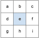
The values of the center cell and its eight neighbors determine the horizontal and vertical deltas. The neighbors are identified as letters from a to i, with e representing the cell for which the aspect is being calculated.
The rate of change in the x direction for cell e is calculated with the following algorithm:
[dz/dx] = ((c + 2f + i) - (a + 2d + g) / (8 * x_cellsize)
The rate of change in the y direction for cell e is calculated with the following algorithm:
[dz/dy] = ((g + 2h + i) - (a + 2b + c)) / (8 * y_cellsize)
Which technically is the slope in that particular direction, but close enough.
and if you are interested in sheet erosion
erdep = [qsx_dx] + [qsy_dy] for prevailing rill erosion
or
erdep = ([qsx_dx] + [qsy_dy]) * 10. for prevailing sheet erosion
