- Home
- :
- All Communities
- :
- Developers
- :
- JavaScript Maps SDK
- :
- JavaScript Maps SDK Questions
- :
- Buffer results
- Subscribe to RSS Feed
- Mark Topic as New
- Mark Topic as Read
- Float this Topic for Current User
- Bookmark
- Subscribe
- Mute
- Printer Friendly Page
- Mark as New
- Bookmark
- Subscribe
- Mute
- Subscribe to RSS Feed
- Permalink
- Report Inappropriate Content
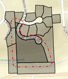
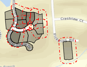
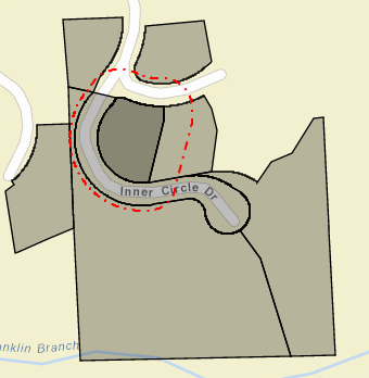
Just notice some issues on JSFiddle Edit fiddle - JSFiddle . When I input this Parcel ID: 1931376038, and run 100 feet buffer. It shows more parcels outside the buffer ring. If I enter this parcel ID 193137602, and add this code like params.unionResults =true in order to combine buffer ring but still shows each single buffer rings. How do you only show all parcels inside buffer ring and if search results are more than one, but only want to show one buffer ring instead of individual buffer ring around each parcels. Thank you.
Solved! Go to Solution.
Accepted Solutions
- Mark as New
- Bookmark
- Subscribe
- Mute
- Subscribe to RSS Feed
- Permalink
- Report Inappropriate Content
May Jeff,
No errors. I also fixed several other things I saw in the code and updated to 3.13 API to use some of the great new stuff like geometryEngineAsync. Here is my updates:
<!DOCTYPE html>
<html>

<head>
  <meta http-equiv="Content-Type" content="text/html; charset=utf-8">
  <!--The viewport meta tag is used to improve the presentation and behavior of the samples
  on iOS devices-->
  <meta name="viewport" content="initial-scale=1, maximum-scale=1,user-scalable=no">
  <title>Buffer</title>

  <link rel="stylesheet" href="http://js.arcgis.com/3.13/dijit/themes/claro/claro.css">
  <link rel="stylesheet" href="http://js.arcgis.com/3.13/esri/css/esri.css">
  <style>
    html,
    body {
      height: 100%;
      width: 100%;
      margin: 0;
      padding: 0;
      overflow: hidden;
    }

    #leftPane {
      color: #000;
      width: 250px;
      padding-bottom: 15px;
    }

    #map {
      padding: 0;
    }

    .details {
      font-size: 14px;
      font-weight: 600;
      padding-bottom: 20px;
    }

    button {
      margin: 2px;
      cursor: pointer;
    }
  </style>

  <script src="http://js.arcgis.com/3.13/"></script>
  <script>
    require([
          "esri/map",
          "esri/config",
          "esri/layers/FeatureLayer",
          "esri/tasks/query",
          "esri/symbols/SimpleLineSymbol",
          "esri/symbols/SimpleFillSymbol",
          "esri/graphic",
          "esri/graphicsUtils",
          "esri/geometry/geometryEngineAsync",
          "esri/tasks/GeometryService",
          "esri/Color",
          "dojo/on",
          "dojo/dom",
          "dijit/registry",
          "dojo/_base/array",
          "dojox/grid/DataGrid",
          "dojo/data/ItemFileReadStore",
          "dijit/form/Button",
          "dojo/parser",
          "dijit/layout/BorderContainer",
          "dijit/layout/ContentPane",
          "dojo/domReady!"
    ], function (
      Map, esriConfig, FeatureLayer, Query, SimpleLineSymbol, SimpleFillSymbol,
      Graphic, graphicsUtils, geometryEngineAsync, GeometryService,
      Color, on, dom, registry, arrayUtils, DataGrid, ItemFileReadStore, Button, parser) {
      var map, center, zoom;
      var grid, store;
      var graphic;
      var bufferGra;

      parser.parse();

      esriConfig.defaults.io.proxyUrl = "/Proxy/proxy.ashx";
      esriConfig.defaults.io.alwaysUseProxy = false;

      registry.byId("applyBufferP").on("click", applyBufferP);
      registry.byId("clearParcelGrid").on("click", clearParcelGrid);
      registry.byId("parcelSearch").on("click", queryParcels);
      registry.byId("intersectBuffer").on("click", intersectParcels);

      center = [-83.266, 42.568];
      zoom = 11;
      map = new esri.Map("map", {
        basemap: "streets",
        center: center,
        zoom: zoom
      });

      var parcelUrl = "http://sampleserver1.arcgisonline.com/ArcGIS/rest/services/TaxParcel/TaxParcelQuery/MapServer/0";
      var featureLayerParcel = new FeatureLayer(parcelUrl, {
        mode: FeatureLayer.MODE_SELECTION,
        visible: true,
        outFields: ["PARCELID", "SITEADDRESS", "OWNERNME1", "OWNERNME2", "RESYRBLT"]
      });
      var symbol = new SimpleFillSymbol(SimpleFillSymbol.STYLE_NULL, new SimpleLineSymbol(SimpleFillSymbol.STYLE_SOLID, new Color([100, 100, 100]), 2), new Color([0, 0, 255, 0.20]));
      featureLayerParcel.setSelectionSymbol(symbol);
      map.addLayer(featureLayerParcel);

      function queryParcels() {
        var queryParcels = new Query();
        queryParcels.where = "PARCELID LIKE '" + "%" + dom.byId("parcelText").value + "'";
        featureLayerParcel.selectFeatures(queryParcels, FeatureLayer.SELECTION_NEW, function (features, selectionMethod) {
          if (features.length > 0) {
            var parcelItems = dojo.map(features, function (feature) {
              return feature.attributes;
            });
            var parcelData = {
              identifier: "PARCELID",
              items: parcelItems
            };
            var parcelStore = new ItemFileReadStore({
              data: parcelData
            });
            var parcelGrid = registry.byId("gridP");
            parcelGrid.on("rowclick", onRowClickHandler);
            parcelGrid.setStore(parcelStore);
            map.setExtent(graphicsUtils.graphicsExtent(featureLayerParcel.getSelectedFeatures()), true);
          } else {
            alert("No Parcels found!");
          }
        });
      }

      function intersectParcels() {
        geometryEngineAsync.union(bufferGra).then(
          function (union) {
            var queryNew = new Query();
            queryNew.outFields = ["PARCELID", "SITEADDRESS", "OWNERNME1", "OWNERNME2", "RESYRBLT"];
            queryNew.spatialRelationship = Query.SPATIAL_REL_INTERSECTS;
            queryNew.geometry = union;
            queryNew.returnGeometry = true;
            featureLayerParcel.selectFeatures(queryNew, FeatureLayer.SELECTION_ADD, function (features, selectionMethod) {
              var items = dojo.map(features, function (feature) {
                return feature.attributes;
              });
              var data = {
                identifier: "PARCELID",
                items: items
              };
              var store = new ItemFileReadStore({
                data: data
              });
              var grid = registry.byId("parcelGrid");
              grid.on("rowclick", onRowClickHandler);
              grid.setStore(store);

              arrayUtils.forEach(features, function (feature) {
                graphic = new Graphic(feature.geometry, symbol);
                map.graphics.add(graphic);
              });
            });
          }
        );
        dijit.byId("dialogOne").show();
      }

      function applyBufferP() {
        var graphics = featureLayerParcel.graphics;
        var selectedGeoms = graphicsUtils.getGeometries(graphics);
        var symbol = new SimpleFillSymbol(SimpleFillSymbol.STYLE_SOLID, SimpleLineSymbol(SimpleLineSymbol.STYLE_SOLID,
            new Color([0, 0, 255, 0.65]), 2
          ),
          new Color([0, 0, 255, 0.35])
        );
        geometryEngineAsync.buffer(selectedGeoms, [100], GeometryService.UNIT_FOOT, true).then(
          function (geoms) {
            arrayUtils.forEach(geoms, function (geometry) {
              map.graphics.add(new Graphic(geometry, symbol));
            });
            bufferGra = geoms;
          }
        );
      }

      function onRowClickHandler(evt) {
        var clickedObjectf = evt.grid.getItem(evt.rowIndex).PARCELID;
        var selectedObjectf;
        var distance = 50;

        dojo.forEach(featureLayerParcel.graphics, function (graphicf) {
          if ((graphicf.attributes) && graphicf.attributes.PARCELID === clickedObjectf) {
            selectedObjectf = graphicf;
            return;
          }
        });

        if (selectedObjectf.geometry.declaredClass == 'esri.geometry.Point') {
          var PointExtent = new esri.geometry.Extent({
            "xmin": selectedObjectf.geometry.x - distance,
            "ymin": selectedObjectf.geometry.y - distance,
            "xmax": selectedObjectf.geometry.x + distance,
            "ymax": selectedObjectf.geometry.y + distance,
            "spatialReference": {
              "wkid": 102100
            }
          });
          map.setExtent(PointExtent);
        } else if (selectedObjectf.geometry.declaredClass == 'esri.geometry.Polygon') {
          var selectedParcel = selectedObjectf.geometry.getExtent();
          map.setExtent(selectedParcel.expand(3));
        } else if (selectedObjectf.geometry.declaredClass == 'esri.geometry.Polyline') {
          var selectedStreetl = selectedObjectf.geometry.getExtent();
          map.setExtent(selectedStreetl.expand(3));
        }
      }

      function clearParcelGrid() {
        var newStore = new ItemFileReadStore({
          data: {
            idenitifer: "",
            items: []
          }
        });
        var grid = registry.byId("gridP");
        grid.setStore(newStore);
        document.getElementById('parcelText').value = '';
        featureLayerParcel.clearSelection();
        map.graphics.clear();
      }
    });
  </script>

  <body class="claro">
    <div data-dojo-type="dijit/layout/BorderContainer" data-dojo-props="design:'headline'" style="width:100%;height:100%;margin:0;">
      <div data-dojo-type="dijit/layout/ContentPane" data-dojo-props="region:'top'" style="height:200px;" title="Search">
        Search by Parcel #:
        <input type="text" id="parcelText" value="1931376029" />
        <br>
        <button id="parcelSearch" data-dojo-type="dijit/form/Button" type="button" data-dojo-attach-point="button">Search</button>
        <button id="clearParcelGrid" data-dojo-type="dijit/form/Button" type="button" data-dojo-attach-point="button">Clear</button>
        <button id="applyBufferP" data-dojo-type="dijit/form/Button" type="button" data-dojo-attach-point="button">Buffer</button>
        <button id="intersectBuffer" data-dojo-type="dijit/form/Button" type="button">Show Parcels Intersecting Buffer</button>
        <table data-dojo-type="dojox/grid/DataGrid" jsid="gridP" id="gridP">
          <thead>
            <tr>
              <th field="PARCELID">Parcel ID</th>
              <th field="OWNERNME1">Owner 1</th>
              <th field="OWNERNME2">Owner 2</th>
              <th field="SITEADDRESS">Address</th>
              <th field="RESYRBLT">Year Built</th>
            </tr>
          </thead>
        </table>
      </div>
      <div id="dialogOne" data-dojo-type="dijit/Dialog" title="Selected Parcels">
        <div data-dojo-type="dijit/layout/ContentPane" title="Selected Parcels">
          <table data-dojo-type="dojox/grid/DataGrid" data-dojo-id="parcelGrid" id="parcelGrid" style="width: 375px; height: 600px" data-dojo-props="rowsPerPage:'100', rowSelector:'20px'">
            <thead>
              <tr>
                <th field="PARCELID">Parcel ID</th>
                <th field="OWNERNME1">Owner 1</th>
                <th field="OWNERNME2">Owner 2</th>
                <th field="SITEADDRESS">Address</th>
                <th field="RESYRBLT">Year Built</th>
              </tr>
            </thead>
          </table>
        </div>
      </div>
      <div id="map" data-dojo-props="region:'center'" data-dojo-type="dijit/layout/ContentPane" style="border:1px solid #000;"></div>
    </div>
  </body>
- Mark as New
- Bookmark
- Subscribe
- Mute
- Subscribe to RSS Feed
- Permalink
- Report Inappropriate Content
The issue is in your doQuery() function. When you set the query geometry you are using the entire extent of the buffer graphic. This is basically a box that contains the graphic (see blue box on image).
    function doQuery() {
        var query = new Query();
        query.geometry = graphic.geometry.getExtent();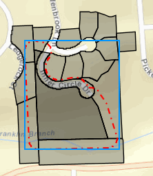
Update your code to just use the buffer geometry:
    function doQuery() {
        var query = new Query();
        query.geometry = graphic.geometry;
- Mark as New
- Bookmark
- Subscribe
- Mute
- Subscribe to RSS Feed
- Permalink
- Report Inappropriate Content
Owen,
After I changed it to query.geometry = graphic.geometry; then I got error message. Can you help me to take a look? Thanks.

- Mark as New
- Bookmark
- Subscribe
- Mute
- Subscribe to RSS Feed
- Permalink
- Report Inappropriate Content
The reason that this is happening is due to the complexity of the shape. For more information see: Using the proxy | Guide | ArcGIS API for JavaScript:
Requests exceed the limit on the length of the uniform resource locators (URLs) imposed by the browser. Common scenarios where you may run into URL length issues are when you use the buffer from a complex polygon as the input to a query task or if you specify a spatial reference using well-known text (WKT).
The proxy needs to be set up on the machine hosting your page. Details are in the page link above.
gs = new GeometryService("http://utility.arcgisonline.com/ArcGIS/rest/services/Geometry/GeometryServer");
esriConfig.defaults.io.proxyUrl = "/proxy/"; // <- the API cannot connect to the proxy location
esriConfig.defaults.io.alwaysUseProxy = false;
Note that this error will not occur for simple property shapes. If I search for 1931376029 in an updated version then the process works - Edit fiddle - JSFiddle
- Mark as New
- Bookmark
- Subscribe
- Mute
- Subscribe to RSS Feed
- Permalink
- Report Inappropriate Content
Thanks for your reply. So I what do need to modify it so it will select the correct parcels inside buffer ring? Can you show me on the JS Fiddle? Try to make it works when enter 1931376038. Thanks for your time.
- Mark as New
- Bookmark
- Subscribe
- Mute
- Subscribe to RSS Feed
- Permalink
- Report Inappropriate Content
Sorry for the late reply - have been on a road trip.
If the proxy is configured then it should also work for 1931376038. Do you have a proxy set up?
- Mark as New
- Bookmark
- Subscribe
- Mute
- Subscribe to RSS Feed
- Permalink
- Report Inappropriate Content
Owne,
Thanks for replying my thread. Finally got time to work on this issue again. I try to use my own services to plug it in and had proxy set up. The error message still the same if query.geometry = graphic.geometry. On the other hand, if query.geometry = graphic.geometry.getExtent(), will get the results but like you said it only get the extent one.
The sample here, all use esri services. Is there any way to set proxy to true?
Thanks.
- Mark as New
- Bookmark
- Subscribe
- Mute
- Subscribe to RSS Feed
- Permalink
- Report Inappropriate Content
If the proxy is set up then the API should automatically use it when it needs to. However, there are some settings that you can configure (from Using the proxy | Guide | ArcGIS API for JavaScript 😞
Using the proxy
In order for your application to route requests through the proxy you must add code to your application to define the location of the proxy. If all requests in your application will use the same proxy you can specify the proxy location using
proxyUrl. You can also specify whether or not the proxy should always be used for communication usingalwaysUseProxyesriConfig.defaults.io.proxyUrl = "<url_to_proxy>" esriConfig.defaults.io.alwaysUseProxy = false;
In the code above, esriConfig refers to the object returned by the esri/config module.
The proxyUrl setting needs to point to the proxy endpoint on the server that is hosting your page. You can also force the API to always use the proxy with the alwaysUseProxy setting.
I would start by changing to alwaysUseProxy = true. Then test your page to make sure that requests are being routed through your proxy. Tools like Fiddler can help show you what HTTP requests are being made from your machine.
- Mark as New
- Bookmark
- Subscribe
- Mute
- Subscribe to RSS Feed
- Permalink
- Report Inappropriate Content
Owen,
Thanks for replying my thread again. Proxy is setting as mentioned above already and also use Fiddler to check the network traffic when using my own map services & proxy.
Besides that, I also rewrite the buffer code with ESRI map services at
Edit fiddle - JSFiddle to see can get the same result when try to search by 1931376029. Looks like query geometry got some issue in this rewrite code. Suppose to get the same answer with this jsfiddle:Edit fiddle - JSFiddle
Unfortunately, so far no luck and still got the same error message with new rewrite code (query geometry) & old code (not return correct parcels) 
Thanks.
- Mark as New
- Bookmark
- Subscribe
- Mute
- Subscribe to RSS Feed
- Permalink
- Report Inappropriate Content
May Jeff,
So let me try to make this as simple as possible. I tested your fiddle code (both of them) and just changed the proxyUrl to use my own proxy and both fiddles worked fine. This tells me that you really don't understand what you are suppose to be putting in the proxyURL. I have a proxy set up on my machine and it's url is http://gislap183/Proxy/proxy.ashx so I change the proxyUrl in your fiddles to:
esriConfig.defaults.io.proxyUrl = "/Proxy/proxy.ashx";
Because when I run your fiddle code (locally) I use the url http://gislap183/js/jeffMay9.html it knows that the proxy is at http://gislap183/Proxy/proxy.ashx and all the code runs fine. So in your code you have
esriConfig.defaults.io.proxyUrl = "/proxy/"; This likely does not point to anything valid on your setup and thus no results. You need to determine what is the actual url to your proxy and use that. If it is a .net proxy then it will likely look like mine and have *.ashx.