- Home
- :
- All Communities
- :
- Products
- :
- ArcGIS Spatial Analyst
- :
- ArcGIS Spatial Analyst Questions
- :
- Changing the Resolution of Digital Surface Models
- Subscribe to RSS Feed
- Mark Topic as New
- Mark Topic as Read
- Float this Topic for Current User
- Bookmark
- Subscribe
- Mute
- Printer Friendly Page
Changing the Resolution of Digital Surface Models
- Mark as New
- Bookmark
- Subscribe
- Mute
- Subscribe to RSS Feed
- Permalink
- Report Inappropriate Content
G’day ESRI forum
I’m having a bit of trouble with, what I assume is something fairly simple.
I’m attempting to produce Digital Surface Models (DSM) from lidar canopy data using the following methodology: http://www.youtube.com/watch?v=Ze4j5WV4ZZU
I have designed an algorithm to identify crown and sub-crown peaks within the DSM using DSM’s with different resolutions (i.e. Terrain models with courser resolution will only identify 1 crown for a given tree while those with finer resolutions may identify 3 or 4 smaller sub-crowns for the same tree).
I can’t seem to work out where in the methodology on the link I can modify resolution so as to generate finer and courser DSM’s.
Would someone be able to point me in the right direction?
Cheers
Matt
P.S. I thought I'd post this as a discussion some time ago but I must have buggered it up somewhere as I am unable to find the discussion anywhere...
- Mark as New
- Bookmark
- Subscribe
- Mute
- Subscribe to RSS Feed
- Permalink
- Report Inappropriate Content
what is the tool that you are using, ArcGIS 10.2.x or others?
Has your LAS data already classified?
- Mark as New
- Bookmark
- Subscribe
- Mute
- Subscribe to RSS Feed
- Permalink
- Report Inappropriate Content
just find the link with operation steps at ArcGIS Help (10.2, 10.2.1, and 10.2.2)
It looks helpful to solve your Q.
Keep in mind that the LiDAR data classification is from data provider with LAS standard 1.1 or later.
- Mark as New
- Bookmark
- Subscribe
- Mute
- Subscribe to RSS Feed
- Permalink
- Report Inappropriate Content
pls refer to Noise Removal and Manual Classification in LAS Cloud
- Mark as New
- Bookmark
- Subscribe
- Mute
- Subscribe to RSS Feed
- Permalink
- Report Inappropriate Content
G'day Larry
Please forgive my confusion but I can't seem to work out how these links relate to my question, they seem focused on classification of the las data prior to creating a terrain.
I'm only trying the change the resolution of the output terrain (i.e. so that each output raster cell in the terrain is for example 1m2, 2m2, 3m2 or whatever...)
Am i missing something in these links?
Regards
Matt
- Mark as New
- Bookmark
- Subscribe
- Mute
- Subscribe to RSS Feed
- Permalink
- Report Inappropriate Content
Matt is this the type of terrain data set you are referring to? ArcGIS Help (10.2, 10.2.1, and 10.2.2) since you mention that you have LAS data, I just want to see if you are indeed using terrain datasets and construction methods.
- Mark as New
- Bookmark
- Subscribe
- Mute
- Subscribe to RSS Feed
- Permalink
- Report Inappropriate Content
I'm afraid I have an exceptionally poor understanding of the method I'm following (Importing LiDAR data into a Terrain using ArcGIS 10 - YouTube) however I believe this is the type. I'm basically converting a las file to a multipoint and then creating a new terrain (a TIN I believe) from this.
Regards
Matt
- Mark as New
- Bookmark
- Subscribe
- Mute
- Subscribe to RSS Feed
- Permalink
- Report Inappropriate Content
When converting a LAS Dataset to TIN, don't convert to multi point (probably the most inefficient data format for LAS data), but use the tool "LAS Dataset To TIN (3D Analyst)" ArcGIS Help (10.2, 10.2.1, and 10.2.2)
- Mark as New
- Bookmark
- Subscribe
- Mute
- Subscribe to RSS Feed
- Permalink
- Report Inappropriate Content
On your reply, it looks that your DSM LAS data has no classification info...
If you want to manually classify this DSM into some classes, including crown and sub-crown peaks, it would be challenging to get accurately.
However, you still can do interactively editing on DSM raster pixels via programming or some editing tools in Remote Sensing packages or ArcGIS:
Generally, within an Area of Interest (AOI) like a kernel of 7X7 (at least, 5X5), delete or replace the AOI with an assigned value (min, max, mean, …) for specific class, which can be carefully chose from your intensive pre-analysis on DSM raster data (after importing from LAS) ... For example, DEM Editing Tool (Using ENVI) | Exelis VIS Docs Center
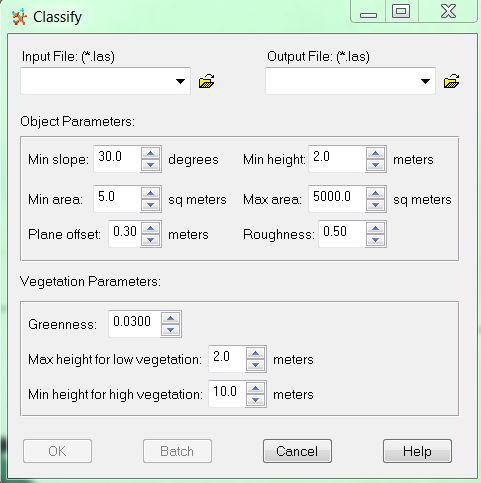
More commom approach is directly 'classify' DSM LiDAR (LAS) by object parameters like vegetation, saying max height for low vegetation is 2 meters, min height for high vegetation is 10 meter (see the snapshot below):
Pls refer to http://www.sirwec.org/Papers/quebec/47.pdf
- Mark as New
- Bookmark
- Subscribe
- Mute
- Subscribe to RSS Feed
- Permalink
- Report Inappropriate Content
On our comparison among raster and TIN imported from LAS, the classes’ results (low vegetation, median vegetation, high vegetation, etc.) from raster, which is done by ' interactively editing on DSM raster pixels', are more realistic and reliable than TIN.
Before effective raster conversion from LAS (by the GP tool LasDatasetToRaster in ArcGIS), it is advisable to divide a larger LAS into small LAS files first.
As said, more reliablely to classify the 'unclassified' DSM LAS data into sub-class, including ground (DTM), city model (buildings), canopy model (low vegetation, median vegetation, high vegetation), etc, it is good to work on object parameters and vegetation parameters like roughness ...