- Home
- :
- All Communities
- :
- Developers
- :
- ArcObjects SDK
- :
- ArcObjects SDK Questions
- :
- which Coordinate system should i use?
- Subscribe to RSS Feed
- Mark Topic as New
- Mark Topic as Read
- Float this Topic for Current User
- Bookmark
- Subscribe
- Mute
- Printer Friendly Page
- Mark as New
- Bookmark
- Subscribe
- Mute
- Subscribe to RSS Feed
- Permalink
- Report Inappropriate Content
when I create a (point) feature class for ArcMobile should i select a Geographic Coordinate System
or should i select a Projected Coordinate System.
it seems like you need both, but can only select one
Also, In ArcMobile the data feature classes and the OffLine basemap need to be the the same Coordinate System
I can't seem to override that like i can in ArcMap.
Solved! Go to Solution.
Accepted Solutions
- Mark as New
- Bookmark
- Subscribe
- Mute
- Subscribe to RSS Feed
- Permalink
- Report Inappropriate Content
use what I've got... just use
ArcObject CoordinateTransformation to convert!!!
- Mark as New
- Bookmark
- Subscribe
- Mute
- Subscribe to RSS Feed
- Permalink
- Report Inappropriate Content
when I export a geo Coordinate test I get the following warning about not having Projected data.
Messages
Executing: ExportXYv t1 OBJECTID;name SPACE C:\Users\walters\Desktop\testmap\geoCoord\t2data NO_FIELD_NAMES
Start Time: Fri Dec 19 11:58:35 2014
Running script ExportXYv...
WARNING 000916: The input feature class does not appear to contain projected data.
Writing Results to ASCII File....
C:\Users\walters\Desktop\testmap\geoCoord\t2data
WARNING 000642: Problems reading 3 of 3 total records.
WARNING 001158: Features with NULL field values (only includes first 30): OBJECTID = 1, 2, 3.
Completed script ExportXYv...
Succeeded at Fri Dec 19 11:58:35 2014 (Elapsed Time: 0.17 seconds)
- Mark as New
- Bookmark
- Subscribe
- Mute
- Subscribe to RSS Feed
- Permalink
- Report Inappropriate Content
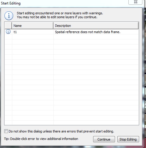
then when I mix in ArcMap with a GeoSpatial reference for the data and projection reference for the data frame properties i get the following error.
- Mark as New
- Bookmark
- Subscribe
- Mute
- Subscribe to RSS Feed
- Permalink
- Report Inappropriate Content
"ArcTutor\Editing" examples "Track" feature class has the same issues with
Export Feature Attribute to ASCII...
I exported the canned data and its latitudes and longitudes are way off!
here are 4 examples:
314465.51513467 4133030.73500869 1 5C Private 3974.353509 631966.999186
315158.74682978 4132913.65509628 2 5D Private 3957.030391 940356.141560
313560.62223985 4132146.81587428 3 5E Private 2390.974762 317791.294922
314158.18890397 4132136.38153100 4 5F Private 1595.929021 159182.592295
is there a way to get export to work?
- Mark as New
- Bookmark
- Subscribe
- Mute
- Subscribe to RSS Feed
- Permalink
- Report Inappropriate Content
marty,
You're posting to the wrong area on GeoNet. This is the GeoNet Help place (or space?).
Goto theGeoNet Community Structure and you'll see all the other location at least one of which will be an appropriate forum. Also be sure to use TAGS.
- Mark as New
- Bookmark
- Subscribe
- Mute
- Subscribe to RSS Feed
- Permalink
- Report Inappropriate Content
use what I've got... just use
ArcObject CoordinateTransformation to convert!!!