- Home
- :
- All Communities
- :
- Developers
- :
- Python
- :
- Python Questions
- :
- How to adjust polyline / polygon vertices in ArcMa...
- Subscribe to RSS Feed
- Mark Topic as New
- Mark Topic as Read
- Float this Topic for Current User
- Bookmark
- Subscribe
- Mute
- Printer Friendly Page
How to adjust polyline / polygon vertices in ArcMap 10.0
- Mark as New
- Bookmark
- Subscribe
- Mute
- Subscribe to RSS Feed
- Permalink
- Report Inappropriate Content
Hi - I am new to using Python and have a database with a lot of polygons and polylines that need to have their vertex coordinates adjusted based on another calculation. I cannot add new fields to the tables, so I want to edit them directly using arcpy code.
I have looked around the web and have not found a clear (to me) procedure (using Arcmap 10.0) to edit and save the new vertex coordinates for each feature.
Our company won't be upgrading Arcmap for at least 6 months or more, so using the da tools in 10.1 is out.
BTW, there are no rings to iterate thru.
I would be happy to buy someone a virtual beer for their assistance. Thanks a bunch!.
Solved! Go to Solution.
Accepted Solutions
- Mark as New
- Bookmark
- Subscribe
- Mute
- Subscribe to RSS Feed
- Permalink
- Report Inappropriate Content
OK, to throw in an example using 10.0 syntax (although in run it on 10.2.2) would be:
import arcpy
fc = r"C:\Forum\EditVertices\test.gdb\polygons"
oid = 2 # objectid to change geometry
# Identify the required fields
desc = arcpy.Describe(fc)
shapefieldname = desc.ShapeFieldName
oidfieldname= desc.OIDFieldName
# create a where clause
where = "{0} = {1}".format(arcpy.AddFieldDelimiters(fc, oidfieldname), oid)
# Create update cursor
rows = arcpy.UpdateCursor(fc, where_clause=where)
# Enter for loop for each feature/row
for row in rows:
# Create the geometry object
feat = row.getValue(shapefieldname)
# create an array for the updated feature
arr_feat = arcpy.Array()
# Step through each part of the feature
partnum = 0
for part in feat:
# create an array for the part
arr_part = arcpy.Array()
# Step through each vertex in the feature
for pnt in feat.getPart(partnum):
if pnt:
x = pnt.X
y = pnt.Y
# do something with the point coordinates
x += 5
y += 5
# add the point to the part array
arr_part.add(arcpy.Point(x, y))
else:
# If pnt is None, this represents an interior ring
pass
# add part to feature array
arr_feat.add(arr_part)
partnum += 1
# create polygon
polygon = arcpy.Polygon(arr_feat)
# set polygon to shapefield and update row
row.setValue(shapefieldname, polygon)
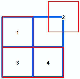
rows.updateRow(row)What happens in the code is that the polygon with OBJECTID is moved (x+5 and y+5). See image below:
If you want to edit vertices of a polygon individually, make sure that the first and last point coincide to force closure of the polygon.
Kind regards, Xander
- Mark as New
- Bookmark
- Subscribe
- Mute
- Subscribe to RSS Feed
- Permalink
- Report Inappropriate Content
Maybe it´s good to read these topics first:
- Mark as New
- Bookmark
- Subscribe
- Mute
- Subscribe to RSS Feed
- Permalink
- Report Inappropriate Content
Yes, I read those and have no trouble reading the vertex information. It's the part about creating a new point in the array and reassigning the array to the original feature that is stumping me. Thanks.
- Mark as New
- Bookmark
- Subscribe
- Mute
- Subscribe to RSS Feed
- Permalink
- Report Inappropriate Content
OK, to throw in an example using 10.0 syntax (although in run it on 10.2.2) would be:
import arcpy

fc = r"C:\Forum\EditVertices\test.gdb\polygons"
oid = 2 # objectid to change geometry

# Identify the required fields
desc = arcpy.Describe(fc)
shapefieldname = desc.ShapeFieldName
oidfieldname= desc.OIDFieldName

# create a where clause
where = "{0} = {1}".format(arcpy.AddFieldDelimiters(fc, oidfieldname), oid)

# Create update cursor
rows = arcpy.UpdateCursor(fc, where_clause=where)

# Enter for loop for each feature/row
for row in rows:

    # Create the geometry object
    feat = row.getValue(shapefieldname)

    # create an array for the updated feature
    arr_feat = arcpy.Array()

    # Step through each part of the feature
    partnum = 0
    for part in feat:

        # create an array for the part
        arr_part = arcpy.Array()

        # Step through each vertex in the feature
        for pnt in feat.getPart(partnum):
            if pnt:
                x = pnt.X
                y = pnt.Y

                # do something with the point coordinates
                x += 5
                y += 5

                # add the point to the part array
                arr_part.add(arcpy.Point(x, y))

            else:
                # If pnt is None, this represents an interior ring
                pass

        # add part to feature array
        arr_feat.add(arr_part)
        partnum += 1

    # create polygon
    polygon = arcpy.Polygon(arr_feat)

    # set polygon to shapefield and update row
    row.setValue(shapefieldname, polygon)
    rows.updateRow(row)
What happens in the code is that the polygon with OBJECTID is moved (x+5 and y+5). See image below:
If you want to edit vertices of a polygon individually, make sure that the first and last point coincide to force closure of the polygon.
Kind regards, Xander
- Mark as New
- Bookmark
- Subscribe
- Mute
- Subscribe to RSS Feed
- Permalink
- Report Inappropriate Content
Thanks - that got me running just fine. I owe you.
In your snippet:
for pnt in feat.getPart(partnum):
if pnt:
what is if pnt: checking for? This seems to be a shortened version of if pnt = something. Can you elaborate? Sorry, I'm a Python newbie...
- Mark as New
- Bookmark
- Subscribe
- Mute
- Subscribe to RSS Feed
- Permalink
- Report Inappropriate Content
Xander's if pnt line checks to see if the object in the list is a point object...if it isn't, it skips the "if" section. This can occur when a feature is a multipart feature and/or has inner rings.
- Mark as New
- Bookmark
- Subscribe
- Mute
- Subscribe to RSS Feed
- Permalink
- Report Inappropriate Content
Thanks Dan Patterson for explaining the reason for checking the pnt object.
- Mark as New
- Bookmark
- Subscribe
- Mute
- Subscribe to RSS Feed
- Permalink
- Report Inappropriate Content
Hi Gary Crowley, Thanx for the virtual beer!
For now I think it's best to mark the answer as correct so other people may find the solution more easy.