- Home
- :
- All Communities
- :
- Developers
- :
- JavaScript Maps SDK
- :
- JavaScript Maps SDK Questions
- :
- How do I get the selected value of combo box and a...
- Subscribe to RSS Feed
- Mark Topic as New
- Mark Topic as Read
- Float this Topic for Current User
- Bookmark
- Subscribe
- Mute
- Printer Friendly Page
How do I get the selected value of combo box and a text box for my layout and format in print settings?
- Mark as New
- Bookmark
- Subscribe
- Mute
- Subscribe to RSS Feed
- Permalink
- Report Inappropriate Content
I have a working print task, but I want the user to be able to select the layout and format independently. How do I get the values of the title, layout and format before the user selects print?
Here is my code:
<!DOCTYPE html>
<html>
<head>
<title>Print a Map</title>
<meta http-equiv="content-type" content="text/html; charset=utf-8">
<meta name="viewport" content="initial-scale=1,maximum-scale=1, user-scalable=no">
<link rel="stylesheet" href="http://js.arcgis.com/3.11/dijit/themes/soria/soria.css">
<link rel="stylesheet" href="http://js.arcgis.com/3.11/esri/css/esri.css">
<style>
html, body, #mapDiv
{
padding:0;
margin:0;
height:100%;
width:100%;
position:absolute;
z-index:0;
}
/* Printer CSS Begin */
h3 { margin: 0 0 5px 0;
border-bottom: 1px solid #444;
padding: 0 0 5px 0;
text-align: center;
}
.shadow
{
-moz-box-shadow: 0 0 5px #888;
-webkit-box-shadow: 0 0 5px #888;
box-shadow: 0 0 5px #888;
}
#feedback
{
background: #fff;
border: 2px solid #666;
border-radius: 5px;
bottom: 20px;
color: #666;
font-family: arial;
height: auto;
left: 20px;
margin: 5px;
padding: 10px;
position: absolute;
width: 300px;
z-index: 40;
/*visibility:hidden; */
}
#feedback a
{
border-bottom: 1px solid #888;
color: #666;
text-decoration: none;
}
#feedback a:hover, #feedback a:active, #feedback a:visited {
border: none;
color: #666;
text-decoration: none;
}
#note
{
padding: 0 0 10px 0;
}
#info, #information
{
padding: 10px 0 0 0;
}
/* Printer CSS End */
#showTools
{
height:20px;
width:20px;
position:absolute;
top:200px;
left:20px;
z-index:50;
padding:5px 6px 5px 6px;
background-color:#f9f8f8;
border-radius:5px;
visibility:visible;
}
#hideTools
{
height:20px;
width:20px;
position:absolute;
top:200px;
left:20px;
z-index:50;
padding:5px 6px 5px 6px;
background-color:#f9f8f8;
border-radius:5px;
visibility:hidden;
}
#printer
{
height:20px;
width:20px;
position:absolute;
top:240px;
left:20px;
z-index:50;
padding:5px 6px 5px 6px;
background-color:#f9f8f8;
border-radius:5px;
visibility:hidden;
}
#printButton
{
visibility:visible;
}
</style>
<script src="http://js.arcgis.com/3.11/"></script>
<script>
var app = {};
require(["esri/map", "esri/config",
"esri/dijit/Print",
"esri/geometry/Extent",
"esri/layers/ArcGISDynamicMapServiceLayer",
"esri/layers/ArcGISTiledMapServiceLayer",
"esri/layers/FeatureLayer",
"esri/tasks/GeometryService",
"esri/tasks/PrintTemplate",
"dojo/_base/array",
"dojo/dom",
"dojo/on",
"dojo/parser",
"dijit/layout/BorderContainer",
"dijit/layout/ContentPane",
"dojo/domReady!"], function (Map, esriConfig, Print, Extent,
ArcGISDynamicMapServiceLayer, ArcGISTiledMapServiceLayer,
FeatureLayer, GeometryService, PrintTemplate, arrayUtils, dom, on, parser
) {
parser.parse();
/* The proxy comes before all references to web services */
/* Files required for security are proxy.config, web.config and proxy.ashx
- set security in Manager to Private, available to selected users and select Allow access to all users who are logged in
(Roles are not required)
/*
The proxy section is defined on the ESRI sample. I have included it as
part of the documentation reads that the measuring will not work.
I thought that might be important.
*/
// Proxy Definition Begin
//identify proxy page to use if the toJson payload to the geometry service is greater than 2000 characters.
//If this null or not available the project and lengths operation will not work.
// Otherwise it will do a http post to the proxy.
esriConfig.defaults.io.proxyUrl = "proxy.ashx";
esriConfig.defaults.io.alwaysUseProxy = false;
// Proxy Definition End
// set custom extent
var initialExtent = new Extent({
"xmin": 777229.03,
"ymin": 1133467.92,
"xmax": 848340.14,
"ymax": 1185634.58,
"spatialReference": {
"wkid": 3435
}
});
// create map and set slider style to small
var map = new Map("mapDiv", {
showAttribution: false,
sliderStyle: "small",
extent: initialExtent
});
// add imagery
var tiled = new ArcGISTiledMapServiceLayer("http://maps.decaturil.gov/arcgis/rest/services/Aerial_2014_Tiled/MapServer");
map.addLayer(tiled);
// set operational layers
var operationalLayer = new ArcGISDynamicMapServiceLayer("http://maps.decaturil.gov/arcgis/rest/services/Public/InternetVector/MapServer", { "opacity": 0.5 });
// add operational layers
map.addLayer(operationalLayer);
// add point feature layer
var pointFeatureLayer = new FeatureLayer("http://maps.decaturil.gov/arcgis/rest/services/Test/FeatureServer/0");
map.addLayer(pointFeatureLayer);
// declare geometry service
esriConfig.defaults.geometryService = new GeometryService("http://maps.decaturil.gov/arcgis/rest/services/Utilities/Geometry/GeometryServer");
// begin print widget
app.printUrl = "http://maps.decaturil.gov/arcgis/rest/services/Utilities/PrintingTools/GPServer/Export%20Web%20Map%2...";
createPrintDijit(document.getElementById("printTitle").value);
function createPrintDijit(printTitle) {
var layoutTemplate, templateNames, mapOnlyIndex, templates;
// create an array of objects that will be used to create print templates
var layouts = [{
//name: "Letter ANSI A Landscape",
label: "Landscape (PDF)",
//format: "pdf",
options: {
legendLayers: [], // empty array means no legend
scalebarUnit: "Miles",
titleText: printTitle
}
}];
// create print templates
var templates = arrayUtils.map(layouts, function (lo) {
var t = new PrintTemplate();
t.layout = document.getElementById("printLayoutId").value;
t.label = lo.label;
t.format = document.getElementById("printFormatId").value;
t.layoutOptions = lo.options;
return t;
});
app.printer = new Print({
map: map,
templates: templates,
url: app.printUrl
}, dom.byId("print_button"));
app.printer.startup();
}
// end of print widget
// Hides print widget
on(dom.byId("closePrint"), "click", function () {
document.getElementById("feedback").style.visibility = 'hidden';
});
// Shows tools
on(dom.byId("showTools"), "click", function () {
document.getElementById("showToolsButton").style.visibility = 'hidden';
document.getElementById("hideToolsButton").style.visibility = 'visible';
document.getElementById("printer").style.visibility = 'visible';
});
// Hide tools
on(dom.byId("hideTools"), "click", function () {
document.getElementById("showToolsButton").style.visibility = 'visible';
document.getElementById("hideToolsButton").style.visibility = 'hidden';
document.getElementById("printer").style.visibility = 'hidden';
document.getElementById("feedback").style.visibility = 'hidden';
});
// Show print widget
on(dom.byId("showPrintWidget"), "click", function () {
document.getElementById("feedback").style.visibility = 'visible';
});
}
);
</script>
</head>
<body class="soria">
<!-- Map Div Begin -->
<div id="mapDiv">
<div id="showTools">
<input type="image" id="showToolsButton" src="images/hammer.png" alt="Show Tools" title="Show Tools" />
</div>
<div id="hideTools">
<input type="image" id="hideToolsButton" src="images/close.ico" alt="Hide Tools" title="Hide Tools" />
</div>
<div id="printer">
<input type="image" id="showPrintWidget" src="images/print.ico" alt="Print" title="Print" />
</div>
<form id="frmPrint" action="">
<div id="feedback">
<h3>
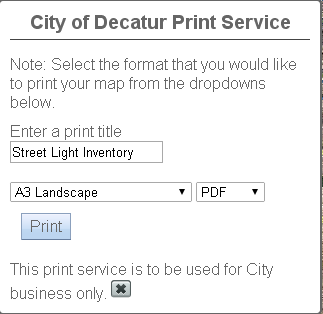
City of Decatur Print Service
</h3>
<div id="information">
<div id="note">
Note: Select the format that you would like to print your map from the dropdowns below.
</div>
<!-- used for the print dijit -->
<label id="lblPrintTitle">Enter a print title</label><br />
<input type="text" id="printTitle" name="printTitle" value="Street Light Inventory" />
<br /><br />
<select name="printLayout" id="printLayoutId">
<option value="A3 Landscape" selected>A3 Landscape</option>
<option value="A3 Portrait">A3 Portrait</option>
<option value="A4 Landscape">A4 Landscape</option>
<option value="A4 Portrait">A4 Portrait</option>
<option value="Letter ANSI A Landscape">Letter ANSI A Landscape</option>
<option value="Letter ANSI A Portrait">Letter ANSI A Portrait</option>
<option value="Tabloid ANSI B Landscape">Tabloid ANSI B Landscape</option>
<option value="Tabloid ANSI B Portrait">Tabloid ANSI B Portrait</option>
</select>
<select name="printFormat" id="printFormatId">
<option value="pdf" selected>PDF</option>
<option value="png32">PNG32</option>
<option value="png8">PNG8</option>
<option value="jpg">JPG</option>
<option value="gif">GIF</option>
<option value="eps">EPS</option>
<option value="svg">SVG</option>
<option value="svgz">SVGZ</option>
</select>
<div id="print_button"></div>
<div id="info">
This print service is to be used for City business only.
<input type="image" id="closePrint" src="images/close.ico" alt="Close" title="Close" />
</div>
</div>
</div>
</form>
</div>
<!-- Map Div End -->
</body>
</html>
- Mark as New
- Bookmark
- Subscribe
- Mute
- Subscribe to RSS Feed
- Permalink
- Report Inappropriate Content
Normally you can just provide the templates and everything to the Print dijit and it handles that for you like this Print templates with esri.request | ArcGIS API for JavaScript . I think to get more fine-grained control you have 2 choices.
- Capture the request using esri/request#setRequestPreCallback and edit the parameters.
- Use the PrintTask and send request manually. I have an older example doing that in this widget esri-print-widget/printdialog.js at master · odoe/esri-print-widget · GitHub .
As far as I can see the Print dijit doesn't have any hooks or events you can tie into to pass those parameters yourself after it has been created. If there is, it would be cool to see.
- Mark as New
- Bookmark
- Subscribe
- Mute
- Subscribe to RSS Feed
- Permalink
- Report Inappropriate Content
I got it to work. There is one small glitch; it duplicates the button with each printout:
<!DOCTYPE html>
<html>
<head>
<title>Print a Map</title>
<meta http-equiv="content-type" content="text/html; charset=utf-8">
<meta name="viewport" content="initial-scale=1,maximum-scale=1, user-scalable=no">
<link rel="stylesheet" href="http://js.arcgis.com/3.11/dijit/themes/soria/soria.css">
<link rel="stylesheet" href="http://js.arcgis.com/3.11/esri/css/esri.css">
<style>
html, body, #mapDiv
{
padding:0;
margin:0;
height:100%;
width:100%;
position:absolute;
z-index:0;
}
/* Printer CSS Begin */
h3 { margin: 0 0 5px 0;
border-bottom: 1px solid #444;
padding: 0 0 5px 0;
text-align: center;
}
.shadow
{
-moz-box-shadow: 0 0 5px #888;
-webkit-box-shadow: 0 0 5px #888;
box-shadow: 0 0 5px #888;
}
#feedback
{
background: #fff;
border: 2px solid #666;
border-radius: 5px;
bottom: 20px;
color: #666;
font-family: arial;
height: auto;
left: 20px;
margin: 5px;
padding: 10px;
position: absolute;
width: 300px;
z-index: 40;
visibility:hidden;
}
#feedback a
{
border-bottom: 1px solid #888;
color: #666;
text-decoration: none;
}
#feedback a:hover, #feedback a:active, #feedback a:visited {
border: none;
color: #666;
text-decoration: none;
}
#note
{
padding: 0 0 10px 0;
}
#info, #information
{
padding: 10px 0 0 0;
}
/* Printer CSS End */
#showTools
{
height:20px;
width:20px;
position:absolute;
top:200px;
left:20px;
z-index:50;
padding:5px 6px 5px 6px;
background-color:#f9f8f8;
border-radius:5px;
visibility:visible;
}
#hideTools
{
height:20px;
width:20px;
position:absolute;
top:200px;
left:20px;
z-index:50;
padding:5px 6px 5px 6px;
background-color:#f9f8f8;
border-radius:5px;
visibility:hidden;
}
#printer
{
height:20px;
width:20px;
position:absolute;
top:240px;
left:20px;
z-index:50;
padding:5px 6px 5px 6px;
background-color:#f9f8f8;
border-radius:5px;
visibility:hidden;
}
</style>
<script src="http://js.arcgis.com/3.11/"></script>
<script>
var app = {};
require(["esri/map", "esri/config",
"esri/dijit/Print",
"esri/geometry/Extent",
"esri/layers/ArcGISDynamicMapServiceLayer",
"esri/layers/ArcGISTiledMapServiceLayer",
"esri/layers/FeatureLayer",
"esri/tasks/GeometryService",
"esri/tasks/PrintTemplate",
"dojo/_base/array",
"dojo/dom",
"dojo/on",
"dojo/parser",
"dijit/layout/BorderContainer",
"dijit/layout/ContentPane",
"dojo/domReady!"], function (Map, esriConfig, Print, Extent,
ArcGISDynamicMapServiceLayer, ArcGISTiledMapServiceLayer,
FeatureLayer, GeometryService, PrintTemplate, arrayUtils, dom, on, parser
) {
parser.parse();
/* The proxy comes before all references to web services */
/* Files required for security are proxy.config, web.config and proxy.ashx
- set security in Manager to Private, available to selected users and select Allow access to all users who are logged in
(Roles are not required)
/*
The proxy section is defined on the ESRI sample. I have included it as
part of the documentation reads that the measuring will not work.
I thought that might be important.
*/
// Proxy Definition Begin
//identify proxy page to use if the toJson payload to the geometry service is greater than 2000 characters.
//If this null or not available the project and lengths operation will not work.
// Otherwise it will do a http post to the proxy.
esriConfig.defaults.io.proxyUrl = "proxy.ashx";
esriConfig.defaults.io.alwaysUseProxy = false;
// Proxy Definition End
// set custom extent
var initialExtent = new Extent({
"xmin": 777229.03,
"ymin": 1133467.92,
"xmax": 848340.14,
"ymax": 1185634.58,
"spatialReference": {
"wkid": 3435
}
});
// create map and set slider style to small
var map = new Map("mapDiv", {
showAttribution: false,
sliderStyle: "small",
extent: initialExtent
});
// add imagery
var tiled = new ArcGISTiledMapServiceLayer("http://maps.decaturil.gov/arcgis/rest/services/Aerial_2014_Tiled/MapServer");
map.addLayer(tiled);
// set operational layers
var operationalLayer = new ArcGISDynamicMapServiceLayer("http://maps.decaturil.gov/arcgis/rest/services/Public/InternetVector/MapServer", { "opacity": 0.5 });
// add operational layers
map.addLayer(operationalLayer);
// add point feature layer
var pointFeatureLayer = new FeatureLayer("http://maps.decaturil.gov/arcgis/rest/services/Test/FeatureServer/0");
map.addLayer(pointFeatureLayer);
// declare geometry service
esriConfig.defaults.geometryService = new GeometryService("http://maps.decaturil.gov/arcgis/rest/services/Utilities/Geometry/GeometryServer");
// begin print widget
app.printUrl = "http://maps.decaturil.gov/arcgis/rest/services/Utilities/PrintingTools/GPServer/Export%20Web%20Map%2...";
function createPrintDijit(printTitle) {
var layoutTemplate, templateNames, mapOnlyIndex, templates;
// create an array of objects that will be used to create print templates
var layouts = [{
//name: "Letter ANSI A Landscape",
label: "Landscape (PDF)",
//format: "pdf",
options: {
legendLayers: [], // empty array means no legend
scalebarUnit: "Miles",
titleText: printTitle
}
}];
// create print templates
var templates = arrayUtils.map(layouts, function (lo) {
var t = new PrintTemplate();
t.layout = document.getElementById("printLayoutId").value;
t.label = lo.label;
t.format = document.getElementById("printFormatId").value;
t.layoutOptions = lo.options;
return t;
});
app.printer = new Print({
map: map,
templates: templates,
url: app.printUrl
}, dom.byId("print_button"));
}
// end of print widget
on(dom.byId("btnPrintReady"), "click", function () {
createPrintDijit(document.getElementById("printTitle").value);
app.printer.startup();
});
// Hides print button after printout complete
// app.printer.on('print-complete',function(evt){
// document.getElementById("print_button").style.visibility = 'hidden';
// });
// Hides print widget
on(dom.byId("closePrint"), "click", function () {
document.getElementById("feedback").style.visibility = 'hidden';
});
// Shows tools
on(dom.byId("showTools"), "click", function () {
document.getElementById("showToolsButton").style.visibility = 'hidden';
document.getElementById("hideToolsButton").style.visibility = 'visible';
document.getElementById("printer").style.visibility = 'visible';
});
// Hide tools
on(dom.byId("hideTools"), "click", function () {
document.getElementById("showToolsButton").style.visibility = 'visible';
document.getElementById("hideToolsButton").style.visibility = 'hidden';
document.getElementById("printer").style.visibility = 'hidden';
document.getElementById("feedback").style.visibility = 'hidden';
});
// Show print widget
on(dom.byId("showPrintWidget"), "click", function () {
document.getElementById("feedback").style.visibility = 'visible';
});
}
);
</script>
</head>
<body class="soria">
<!-- Map Div Begin -->
<div id="mapDiv">
<div id="showTools">
<input type="image" id="showToolsButton" src="images/hammer.png" alt="Show Tools" title="Show Tools" />
</div>
<div id="hideTools">
<input type="image" id="hideToolsButton" src="images/close.ico" alt="Hide Tools" title="Hide Tools" />
</div>
<div id="printer">
<input type="image" id="showPrintWidget" src="images/print.ico" alt="Print" title="Print" />
</div>
<form id="frmPrint" action="" onsubmit="return false;">
<div id="feedback">
<h3>
City of Decatur Print Service
</h3>
<div id="information">
<div id="note">
Note: Select the format that you would like to print your map from the dropdowns below.
</div>
<!-- used for the print dijit -->
<label id="lblPrintTitle">Enter a print title</label><br />
<input type="text" id="printTitle" name="printTitle" value="Street Light Inventory" />
<br /><br />
<select name="printLayout" id="printLayoutId">
<option value="A3 Landscape" selected>A3 Landscape</option>
<option value="A3 Portrait">A3 Portrait</option>
<option value="A4 Landscape">A4 Landscape</option>
<option value="A4 Portrait">A4 Portrait</option>
<option value="Letter ANSI A Landscape">Letter ANSI A Landscape</option>
<option value="Letter ANSI A Portrait">Letter ANSI A Portrait</option>
<option value="Tabloid ANSI B Landscape">Tabloid ANSI B Landscape</option>
<option value="Tabloid ANSI B Portrait">Tabloid ANSI B Portrait</option>
</select>
<select name="printFormat" id="printFormatId">
<option value="pdf" selected>PDF</option>
<option value="png32">PNG32</option>
<option value="png8">PNG8</option>
<option value="jpg">JPG</option>
<option value="gif">GIF</option>
<option value="eps">EPS</option>
<option value="svg">SVG</option>
<option value="svgz">SVGZ</option>
</select>
<button type="button" id="btnPrintReady">Print Ready</button>
<div id="print_button"></div>
<div id="info">
This print service is to be used for City business only.
<input type="image" id="closePrint" src="images/close.ico" alt="Close" title="Close" />
</div>
</div>
</div>
</form>
</div>
<!-- Map Div End -->
</body>
</html>